Draft Local Plan-Part 2 Site Allocations
Norwich and Urban Fringe
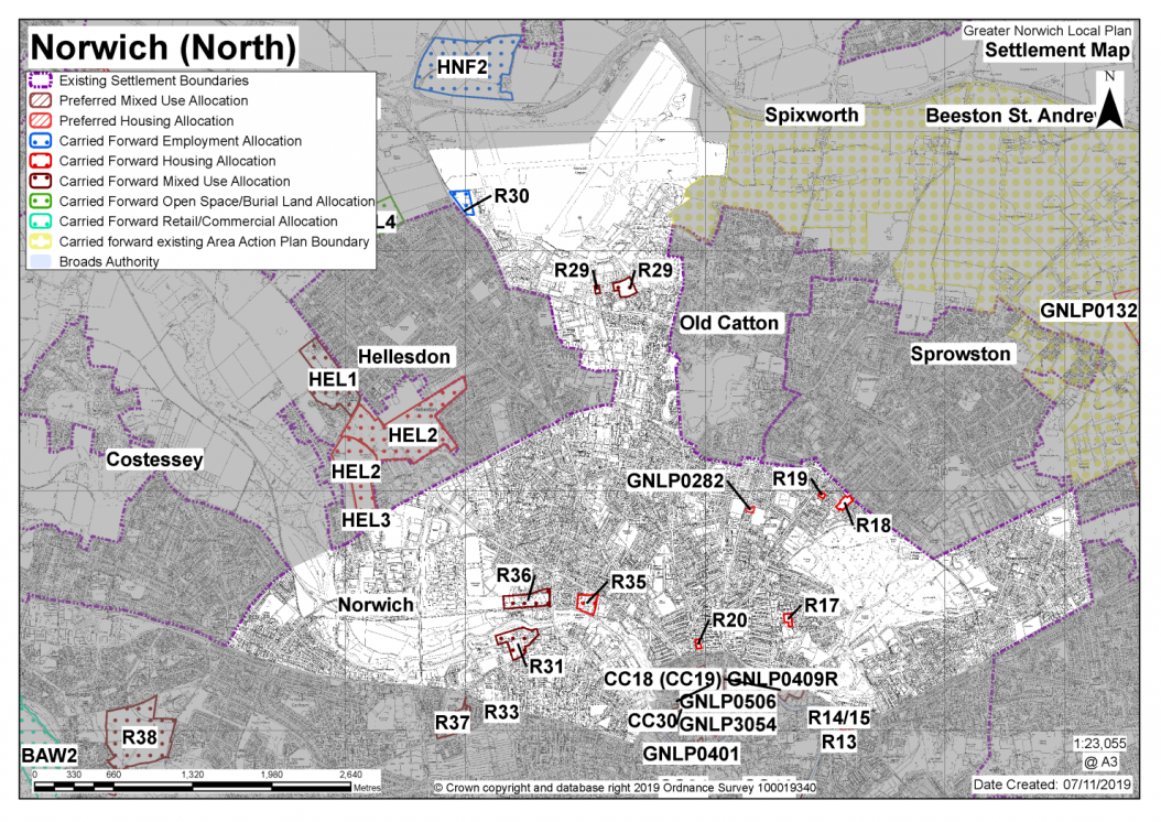
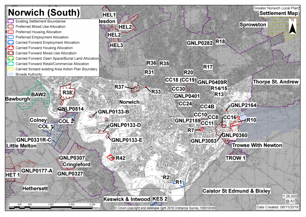
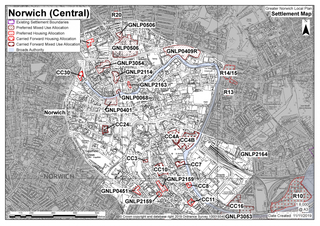
NORWICH
The Norwich urban area is at the top of the GNLP settlement hierarchy. As the most accessible and sustainable location in the area, Norwich benefits from a high level of accessibility to a broad range of local and sub-regional services and facilities. In this Local Plan, Norwich will retain that prime position and be promoted for a significant share of housing and economic development in the GNLP. The area within the city boundary is largely built up and no large-scale greenfield sites remain available to allocate. Therefore, Norwich's potential for the delivery of new housing and economic development will be reliant on the use of previously developed land and premises, increasing densities and housing-led regeneration and renewal, particularly in the city centre.
Important considerations
Norwich has many assets like open spaces, green infrastructure and the river valleys of the Wensum and Yare. The landscape setting of Norwich and the proximity of the Broads are other considerations. All these assets will limit the scale and location of development in Norwich. The major heritage significance of parts of the city mean that particular care needs to be taken in planning, locating and designing new development.
Numbers of new homes in Norwich
1,085 homes were delivered in Norwich between the base date of 1st April 2018 to 31st March 2019. 6,497 new homes could potentially be built on sites with unimplemented planning permissions and allocations in existing local plans (as at 1st April 2019). In addition, there is a significant amount of private and institutional purpose-built student accommodation, and other institutional residential developments permitted (approximately 2,130 bedrooms as at April 2019). Using the adjustment calculations set out in the Housing Delivery Test Measurement Rule Book[1]; this would release the equivalent of 852 additional homes based on one home per 2.5 bedrooms. This would give a total potential commitment of 8,014 homes. However, evidence suggests that an estimated 1,347 homes in existing local plan allocations are unlikely to be delivered within the plan period; so these allocations are not proposed to be carried forward. Discounting the sites regarded as undeliverable, Norwich's net deliverable commitment (consisting of carried forward allocations extant planning consents (including student accommodation), is calculated at equivalent to 7,087 homes.
Norwich and the surrounding area
The Local Plan directs a high proportion of homes to the most sustainable and accessible locations in Norwich city and the urban fringe. Together, Norwich and the Urban Fringe contribute just under 70 percent share of the plan allocation overall. The Towards a Strategy document indicates that Norwich city could potentially accommodate 2,500 homes in new housing allocations. Taking into account the 7,087 homes discussed previously, this makes a total minimum plan requirement of 9,500 homes.
Meeting the development needs in Norwich
Although a relatively small number of completely new allocations are proposed, there is considerable potential to increase housing densities on previously identified sites; particularly in and adjoining the city centre (which will also be a focus for employment, retail, leisure, educational and cultural facilities).
The plan proposes a limited number of allocations for employment use and other uses carried forward from previous local plans: this includes three sites providing for the longer-term expansion of the University of East Anglia.
Norwich City Council's existing planning documents
Norwich City Council has recently undertaken an assessment of the Development Management Policies and Site Allocation policies (adopted December 2014) in accordance with Regulation 10A of the Town and Country Planning (Local Planning) (England) Regulations 2017 as they are nearly five years old. There is no immediate case for commencing full or partial review of the DM Policies plan (as set out in the report to Cabinet in November 2019), however there is a case for commencing a full review of the plan following the Regulation 19 consultation of the GNLP but before the start of the public examination. There is no need for the city council to review the Site allocations plan as this is currently being reviewed through the preparation of the GNLP.
|
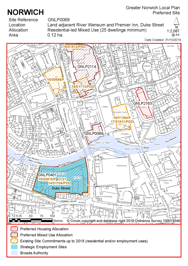
POLICY GNLP0068 Land adjacent to the River Wensum and the Premier Inn, Duke Street (approx. 0.12ha) is allocated for residential-led mixed use development. This will include a minimum of 25 homes of which at least 7 homes (or 28%) should be affordable. A small element of commercial, office, and/or educational use at ground floor level may also be acceptable.
The development will achieve the following site-specific requirements:
|
Notes: GNLP0068
Although not previously allocated in the Local Plan, the site benefits from an extant 2004 permission for 21 homes. That permission has been implemented and remains valid through the construction of the hotel forming part of the same approved proposals. Further to this, a recent permission was granted in November 2019 for the construction of a 139 bed Purpose Built Student Accommodation Block. The site is likely to accommodate at least 25 homes. More may be accommodated, subject to an acceptable design and layout etc. being achieved.
UEA POLICIES: GNLP0133-B, GNLP0133-C, GNLP0133-D & GNLP0133-E:
These sites are expected to be developed for the purposes proposed below within the new local plan time-period up to 2038. This coincides with the period covered by the emerging revised Development Framework Strategy (DFS refresh) being prepared by the UEA. Once finalised and endorsed by Norwich City Council as local planning authority, the DFS refresh will provide additional detailed evidence and guidance to inform detailed development proposals both on the specific sites allocated in this plan and elsewhere within the campus.
|
POLICY GNLP0133-B Land adjoining the Enterprise Centre at Earlham Hall (walled garden and nursery 1.38ha) is allocated for university-related uses, including offices (Use class B1(a)), research and development (Use class B1(b)) and educational uses (Use class D1) providing in the region of 5,000 sq.m of floorspace.
The development will achieve the following site-specific requirements:
|
Notes: GNLP0133-B:
The site was allocated in the previous Local Plan for business use to include an exemplar low-carbon building. The first phase of development comprising the Enterprise Centre is complete and operating. Low rise development within the constraints of this sensitive setting is considered appropriate, as outlined within the now lapsed outline planning permission for the site. Development meeting the future expansion needs of the University as detailed in the emerging Development Framework Strategy remains appropriate. The site is reallocated for development for university-related uses to include offices, research and development and educational uses.
|
POLICY GNLP0133-C Land north of Cow Drive (the Blackdale Building, adjoining Hickling House and Barton House, University of East Anglia, 0.89 hectare) is allocated for student accommodation development which may include a small element of ancillary university related uses. The site is expected to accommodate a minimum of 400 student bedrooms and is to provide affordable housing in accordance with policy 5, subject to viability considerations.
The development will achieve the following site-specific requirements:
|
Notes GNLP0133-C:
The site is likely to accommodate around 400 student bedrooms, (equivalent to 160 homes, as per footnote 1).
The site benefits from a partly implemented planning permission for a 915-bed student accommodation development; the first 514-bed phase of which (Hickling House and Barton House) is complete. Should the second consented phase not proceed, development of a similar scale and form is appropriate in this location. The consented second phase of the scheme is already included within the housing commitment calculation. If a variation to the consented scheme or new planning application come forward, affordable housing will be provided in accordance with Policy 5.
|
POLICY GNLP0133-D Land between Suffolk Walk and Bluebell Road, (2.74 hectares) is allocated for university related development for both academic and non-academic uses.
The development will achieve the following site-specific requirements:
|
Notes GNLP0133-D: The site is identified in the adopted Norwich Site Allocations and Site-Specific Policies Local Plan as a strategic reserve to accommodate the anticipated future expansion of the University (site reference R41).
|
POLICY GNLP0133-E Land at the UEA Grounds Depot Site, Bluebell Road (approx. 1.60 ha) is allocated for student accommodation development which may include a small element of ancillary university related uses. The site is expected to accommodate in the region of 400 student bedrooms and is to provide affordable housing in accordance with policy 5, subject to viability considerations.
The development will achieve the following site-specific requirements:
|
Notes GNLP0133-E:
The site is likely to accommodate around 400 student bedrooms, equivalent to 160 homes.
|
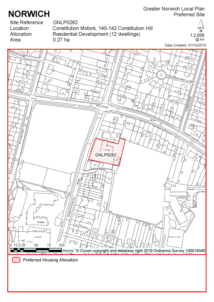
POLICY GNLP0282 Land at Constitution Motors, 140-142 Constitution Hill (approx. 0.27 ha) is allocated for residential development. This will provide a minimum of 12 homes of which at least 4 homes (or 33%) should be affordable. The development will achieve the following site-specific requirements:
|
Notes GNLP0282:
The site is expected to accommodate approximately 12 homes. A mix of dwelling sizes would be appropriate. The development will include affordable housing, in accordance with Policy 5, providing a mix of affordable tenures consistent with identified needs at the time of submission of a planning application and subject to viability. The site has extant outline planning permission for residential development broadly, in accordance with the allocation.
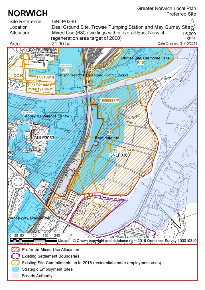
Notes GNLP0360:
The site is likely to accommodate at least 680 homes contributing to an overall target of 2,000 in the East Norwich strategic regeneration area. This will include affordable housing providing a mix of affordable tenures consistent with identified needs at the time of submission of a planning application and subject to viability. More housing may be accommodated, subject to an acceptable design and layout being achieved and contingent on the scope for enhanced infrastructure provision and increased highway network capacity in the area.
A significant proportion of the site falling within Norwich is allocated in the adopted 'Site allocations and site-specific policies' plan and the major part of it also benefits from outline permission for residential led mixed-use development, although this has not yet been progressed. This is a cross boundary allocation as part of this site also falls within South Norfolk jurisdiction (this is a single policy covering the cross-boundary site).
The anticipated release of the adjoining Carrow Works site for development presents the opportunity to achieve improved integration of the two sites including a potential new access route into the Deal Ground from Carrow Works passing under the rail line, which is due for upgrading in conjunction with the potential replacement of Trowse Swing Bridge. Regeneration of the two sites in conjunction with the Utilities site as a new gateway quarter could act as a catalyst for wider regeneration of East Norwich and beyond within the timeframe of this local plan. Relocation of the existing aggregate processing facility and railhead would be desirable to achieve comprehensive regeneration.
As an existing allocation this site is included in the housing commitment figure and has been considered in the calculation of the housing requirement.
|
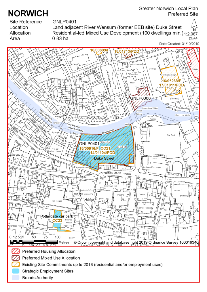
POLICY GNLP0401 Former Eastern Electricity Headquarters, (Duke's Wharf) Duke Street (approx. 0.83ha) is allocated for mixed-use development which may include a minimum of 100 homes, (or, if the residential element is provided as student accommodation, at least 250 bedrooms). Affordable Housing provision should be in line with Policy 5, subject to viability. Employment, managed workspace, leisure, financial and professional services, education and cultural uses will also be acceptable as part of a balanced mix.
The development will achieve the following site-specific requirements:
|
Notes GNLP0401:
The site is likely to accommodate at least 100 homes, or if the site is developed to include student accommodation (at least 250 bedrooms) a contribution to affordable housing in accordance with Policy 5 including affordable housing with a mix of affordable tenures consistent with identified needs at the time of submission of a planning application and subject to viability. More housing may be accommodated, subject to an acceptable design and layout being achieved.
69 flats delivered through conversion of existing buildings under previous approved proposals are included in the existing housing commitment.
|
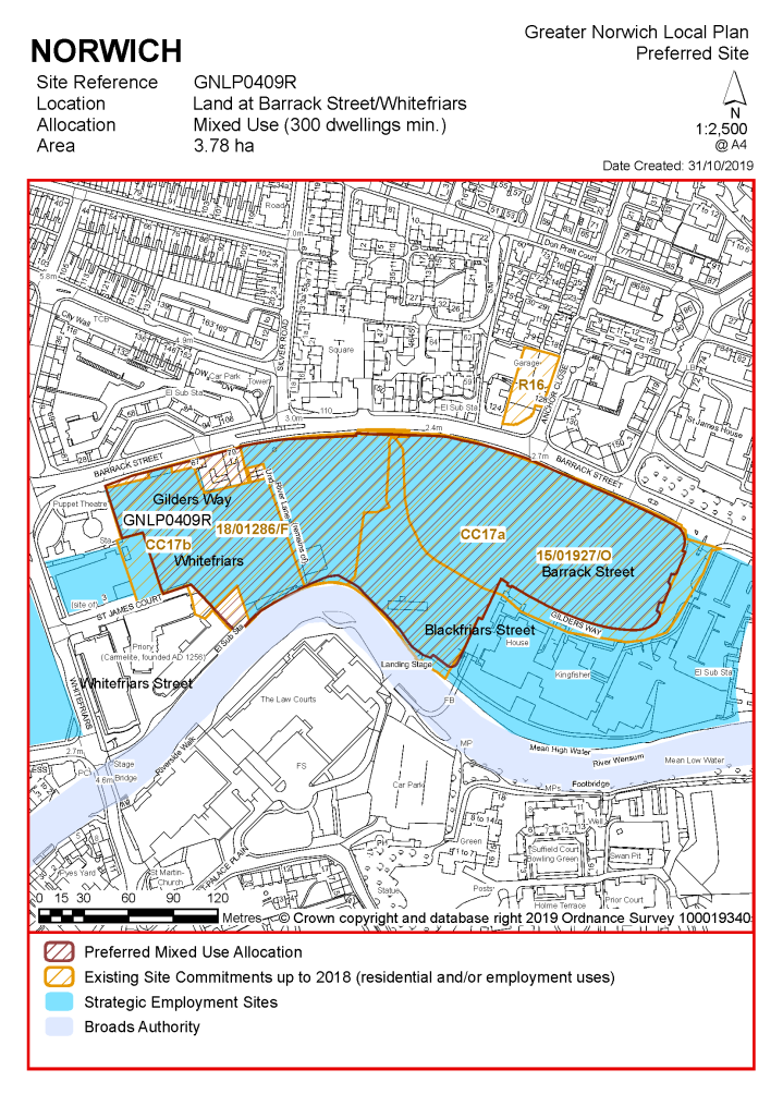
POLICY GNLP0409R Land at Barrack Street/Whitefriars (approx. 3.78 hectares) is allocated for residential-led mixed-use development. This will include a minimum of 300 homes, of which at least 84 homes (or 28%) should be affordable. Offices and managed workspace, ancillary retail use, restaurants, bars, and recreational open space will be accepted as part of a balanced mix of uses.
The development will achieve the following site-specific requirements:
|
Notes GNLP0409R:
The site was previously allocated in the adopted 'Site allocations and site-specific policies' plan in two parts. The western half nearest to Whitefriars identified for office development and the eastern half for mixed use development with housing and an element of offices, reflecting aspirations to deliver the remaining consented phases of the partially completed St James's Place office quarter.
Consented proposals for both parts of the site as at April 2019 could potentially deliver up to 418 new homes (200 of which form part of the existing housing commitment), 8,100 sq.m of offices, open space, car parking to serve existing and proposed office users and ancillary retail and commercial uses.
To allow for flexibility and the option of securing a larger element of office and commercial development to deliver economic benefits if market conditions permit, the minimum housing allocation has been set at 300 homes, although more housing may be accommodated subject to an acceptable design and layout being achieved. This will include affordable housing providing a mix of affordable tenures consistent with identified needs at the time of submission of a planning application and subject to viability.
|
POLICY GNLP0451 Land adjoining Sentinel House, (St Catherine's Yard) Surrey Street (approx. 0.38 hectares) is allocated for residential development. This will provide a minimum of 40 homes, of which at least 11 homes (or 28%) should be affordable (or, if developed for student accommodation, a minimum of 200 student bedrooms). Commercial uses including small scale retail, financial and professional services, restaurants/cafes or other main town centre uses will be accepted at ground floor level where compatible with adjoining residential uses.
The development will achieve the following site-specific requirements:
|
Notes GNLP0451:
The site was previously allocated for mixed use development of offices and housing in the adopted 'Site allocations and site-specific policies' plan alongside the adjacent Council-owned Queens Road car park, the majority of the existing car park is not proposed to take forward for reallocation in this plan. Around the same number of homes (or equivalent student bedrooms) may be deliverable from this smaller site without the car park being included, albeit that the development capacity of the allocation will be limited by the proximity of adjoining housing and the need to conserve and enhance heritage assets. By virtue of the allocation of this site for an equivalent number of dwellings in the previous local plan the site has already been considered in the calculation of the housing requirement. It should be noted that Sentinel House itself was originally put forward for consideration in the plan but has since been converted to housing under prior approval and is not expected to deliver any additional housing in the plan period.
|
POLICY GNLP0506 Land at and adjoining Anglia Square, Norwich (approx. 4.79 hectares) is allocated for residential-led, mixed-use development as the focus for an enhanced and improved large district centre and to act as a catalyst for wider investment and redevelopment within the Northern City Centre strategic regeneration area as defined in policy 7.1 of this plan. The site will deliver in the region of 1200 homes to provide affordable housing in accordance with policy 5, subject to viability considerations.
The development will achieve the following site-specific requirements:
|
Notes GNLP0506:
The site is likely to accommodate in the region of 1200 homes, a minimum of 120 of which will be affordable, providing a mix of affordable tenures consistent with identified needs at the time of submission of a planning application and subject to viability.
|
POLICY GNLP2114 Land at and adjoining St Georges Works, Muspole Street (approx. 0.57 ha) is allocated for residential-led mixed use development. This has the potential to provide a minimum of 110 homes, of which at least 31 homes (or 28%) should be affordable, together with a minimum of 5000sqm offices and managed workspace and potentially other ancillary uses such as small-scale retailing.
The development will achieve the following site-specific requirements:
|
Notes GNLP2114:
The St Georges' Works site includes Seymour House and Lion House, Muspole Street and premises known as the Guildyard, Colegate which were historically part of the shoe factory complex so are included in the proposed allocation. The Guildyard and Seymour House have benefitted from prior approval consents for conversion to a total of 60 flats which are already included in the housing commitment. The central part of the site was previously allocated for residential development (minimum 40 dwellings) in the now expired Northern City Centre Area Action Plan and the principle of such development has been established by the grant of permission for a 53-dwelling scheme consistent with that allocation (Permission expired). The site has significant longer-term potential for regeneration and additional housing delivery but currently acts as the base for a range of small start-up companies in modernised managed workspace. Retention of the existing employment space on site is highly desirable as part of a wider initiative in the Northern City Centre Strategic Regeneration Area. Given the importance of retaining and extending employment opportunities in the city centre, it would not be appropriate to replace the existing employment uses in favour of housing. The policy consequently recognises that there is scope for a flexible mix of both, allowing for up to 150 homes as an indicative maximum including employment space as part of a balanced mix.
|
POLICY GNLP2159 Land at 84-120 Ber Street, 147-153 Ber Street and Mariners Lane Car Park (approx. 0.70 hectare) is allocated for housing development. This will provide a minimum of 150 homes, of which at least 42 homes (or 28%) should be affordable. Office or other commercial uses at ground floor level would also be acceptable with scope for educational uses in association with the adjacent Notre Dame High School being provided on the south-west side of Ber Street.
The development will achieve the following site-specific requirements:
|
Notes GNLP2159:
The site is expected to accommodate a minimum of 150 homes. This will include affordable housing providing a mix of affordable tenures consistent with identified needs at the time of submission of a planning application and subject to viability. Part of the site on the south-west side of Ber Street (147-153 Ber Street) was allocated in the previous local plan for a minimum of 20 homes and is included within the housing commitment.
|
POLICY GNLP2163 Friars Quay Car Park, Colegate (former Wilson's Glassworks site, approx. 0.13 hectares) is allocated for residential development. This will provide a minimum of 25 homes, of which at least 7 homes (28%) should be affordable. Offices or other commercial uses would be appropriate as a small element of the scheme on the frontage to Colegate. The development will achieve the following site-specific requirements:
|
Notes GNLP2163:
The site is expected to accommodate at least 25 homes. This will include affordable housing providing a mix of affordable tenures consistent with identified needs at the time of submission of a planning application and subject to viability, in accordance with Policy 5. The site was previously allocated in the now expired Northern City Centre Area Action Plan for residential-led mixed use development and has been subject to previous development proposals which were withdrawn before determination, accordingly the principle of housing development is accepted.
|
POLICY GNLP2164 Land west of Eastgate House, Thorpe Road (approx. 0.19 ha) is allocated for residential development. This will provide in the region of 20 homes, of which at least 7 homes (or 33%) should be affordable.
The development will achieve the following site-specific requirements:
|
Notes GNLP2164:
The site is expected to accommodate in the region of 20 homes. This will include affordable housing providing a mix of affordable tenures consistent with identified needs at the time of submission of a planning application and subject to viability. The site has been subject to previous outline proposals for residential development broadly in accordance with the allocation. Despite the refusal of a recent outline planning application in the absence of a mechanism to secure affordable housing, the principle of residential development is acceptable and has been supported.
|
POLICY GNLP3053 Land at Carrow Works, Norwich (approx. 20.00 ha) is allocated for residential led mixed use development including housing, community, education and leisure facilities, local employment and retail, local greenspace, biodiversity areas and recreational open space as part of a balanced mix together with all necessary supporting vehicular, pedestrian, cycle and public transport access infrastructure. The site is expected to accommodate a minimum of 1200 homes subject to confirmation through detailed master planning of the wider East Norwich Strategic Regeneration Area as defined in policy 7.1 of this plan (which in total is expected to deliver a minimum of 2000 homes, of which at least 33% should be affordable).
The development will achieve the following site-specific requirements:
|
Notes GNLP3053:
Carrow Works was formerly the location for Britvic Soft Drinks Ltd. and Unilever UK Ltd., and is being promoted for redevelopment. The allocation site, which also includes Carrow House owned by Norfolk County Council, is likely to accommodate at least 1200 homes contributing to an overall target of 2000 in the East Norwich strategic regeneration area. This will include affordable housing providing a mix of affordable tenures consistent with identified needs at the time of submission of a planning application and subject to viability. More housing may be accommodated, subject to viability, an acceptable design and layout being achieved and contingent on the scope for enhanced infrastructure provision and increased highway network capacity in the area.
The release of the Carrow Works site for development presents the opportunity to achieve improved integration with the Deal Ground including a potential new access route into the Deal Ground from the site passing under the rail line, which is due for upgrading in conjunction with the replacement of Trowse Swing Bridge. Regeneration of the two sites in conjunction with the Utilities site as a new gateway quarter could act as a catalyst for wider regeneration of East Norwich and beyond within the timeframe of this local plan. Relocation of the existing aggregate processing facility and railhead would be desirable to achieve comprehensive regeneration.
|
POLICY GNLP3054 The site at St Mary's Works and St Mary's House (1.05 ha) is allocated for comprehensive mixed-use development to include residential and employment uses, with the possible addition of a hotel. The site will deliver a minimum of 150 homes including 42 (or 28%) units of affordable housing.
The development will achieve the following site-specific requirements:
|
Notes GNLP3054:
The site is situated in a prominent location within the Northern City Centre strategic regeneration area, as defined in policy 7.1 of this plan, and is likely to accommodate a minimum of 150 homes. It benefits from extant outline consent for redevelopment including around 151 residential units, office floor space, and a hotel.
Existing Allocations to be Carried Forward
|
POLICY CC2 147 – 153 Ber Street, Norwich The site is reallocated together with 84-120 Ber Street and Mariners Lane Car Park. See POLICY GNLP2159.
|
|
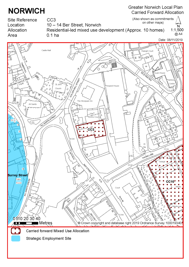
POLICY CC3 10 – 14 Ber Street, Norwich (approx. 0.10 ha) is allocated for residential-led mixed use development. This will accommodate a minimum of 10 homes, of which at least 3 (or 28%) should be affordable housing.
The development will achieve the following site-specific requirements:
|
Notes CC3:
The site was allocated in the previous Local Plan but has not yet been developed. The principle of development is already accepted, and it is expected that development will take place within the new local plan time-period up to 2038. The site is re-allocated for residential development. As an existing allocation it has been considered in the calculation of the housing requirement.
The site is likely to accommodate at least 10 homes. This will include affordable housing providing a mix of affordable tenures consistent with identified needs at the time of submission of a planning application and subject to viability. More may be accommodated, subject to an acceptable design and layout etc. being achieved.
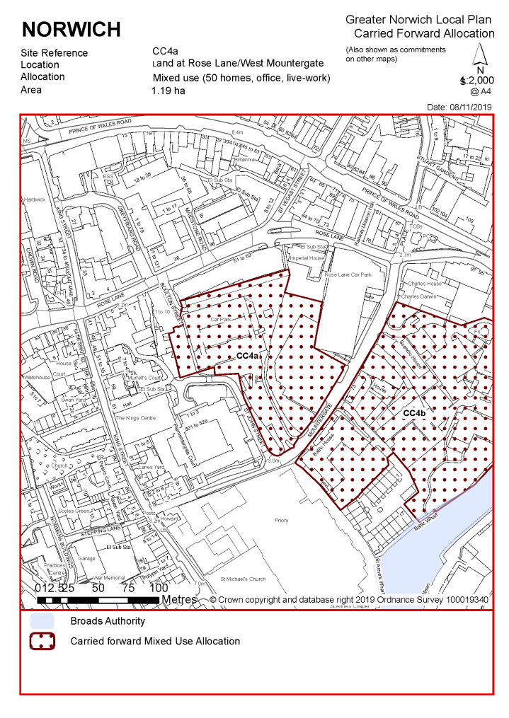
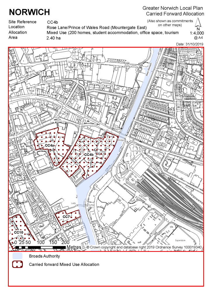
POLICY CC4 Land at Rose Lane/Mountergate
(Rose Lane/Mountergate is proposed to be reallocated in two parts on modified boundaries, as follows:
|
POLICY CC4a Land at Rose Lane/Mountergate (Mountergate West, approx. 1.19 ha) is allocated for mixed-use development to include high quality office space, managed workspace and live-work units, and up to 50 homes to provide affordable housing in accordance with policy 5, subject to viability considerations.
The development will achieve the following site-specific requirements:
|
|
POLICY CC4b Land Mountergate/Prince of Wales Road (Mountergate East, approx. 2.40 ha) is allocated for mixed-use development. This may accommodate a minimum of 200 homes, to provide affordable housing in accordance with policy 5, subject to viability considerations; together with student accommodation, high quality office space, hotel and tourism uses, and other supporting main town centre uses taking advantage of the site's proximity to the rail station and river.
The development will achieve the following site-specific requirements:
|
Notes CC4a and CC4b:
Sites CC4a and CC4b were identified in the previous Local Plan as a single allocation CC4. Within the area of the original allocation there has been limited redevelopment and change of use of premises and sites closest to Rose Lane. Completed developments include the refurbishment of the Union Building for managed workspace, conversion of Imperial House to flats, construction of the replacement Rose Lane Car Park and establishment of the Charles Darwin Primary Academy within former office buildings fronting Prince of Wales Road. Due to the recent completion of these developments, these premises are proposed to be excluded from the revised allocation. Emerging proposals providing for the potential redevelopment and replacement of the dated Hotel Nelson (Premier Inn) including complementary mixed-use development, strongly favour integration of that site within the allocation to exploit the potential of its river frontage.
Evidence from the GVA Employment and Town Centres study 2018 points to significant demand for high quality employment space for developing businesses in the digital creative sector and other sectors supporting the city centre economy, preferably requiring a location close to sustainable transport hubs. Accordingly, scope for a significant element of employment use is identified in site CC4a west of Mountergate to take advantage of its location close to Norwich Rail Station. Land east of Mountergate (CC4b) is promoted for a broader mix of uses with a significant element of residential use, effective integration of the Hotel Nelson site and possible reuse or redevelopment of offices at Baltic House. The general principle of development on the site has already been accepted, and it is expected that development will take place within the new local plan time-period up to 2038.
As an existing allocation, 250 homes have been considered in the calculation of the housing requirement.
Sites CC4a and 4b are likely to accommodate at least 250 homes with around 50 being accommodated on site CC4a and 200 on site CC4b. This will include affordable housing providing a mix of affordable tenures consistent with identified needs at the time of submission of a planning application and subject to viability. More may be accommodated, subject to an acceptable design and layout being achieved.
|
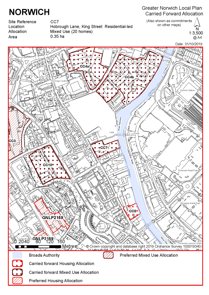
POLICY CC7 Hobrough Lane, King Street, Norwich (approx. 0.35ha) is allocated for residential-led mixed use development. This will accommodate a minimum of 20 homes, of which at least 6 (or 28%) should be affordable.
The development will achieve the following site-specific requirements:
|
Notes CC7:
The site was allocated in the previous Local Plan and was subject to two previous approved schemes on adjoining parts of the site which together would have delivered a total of 20 homes. These permissions have expired, and the site has not yet been developed. The principle of development on the site has already been accepted, and it is expected that development will take place within the new local plan time-period up to 2038. The site is re-allocated for residential use.
As an existing allocation, 20 homes have been considered in the calculation of the housing requirement.
The site is likely to accommodate at least 20 homes. This will include affordable housing providing a mix of affordable tenures consistent with identified needs at the time of submission of a planning application and subject to viability. More homes may be accommodated, subject to an acceptable design and layout etc. being achieved and heritage impact and other constraints being adequately addressed.
|
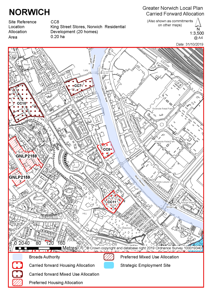
POLICY CC8 King Street Stores, Norwich (approx. 0.20ha) is allocated for residential use. This will accommodate a minimum of 20 homes, of which at least 6 (or 28%) should be affordable.
The development will achieve the following site-specific requirements:
|
Notes CC8:
The site was allocated in the previous Local Plan but has not yet been developed. The principle of development on the site has already been accepted, and it is expected that development will take place within the new local plan time-period up to 2038. The site is re-allocated for residential development. As an existing allocation it has been considered in the calculation of the housing requirement.
The site is likely to accommodate at least 20 homes. More may be accommodated, subject to an acceptable design and layout etc. being achieved.
|
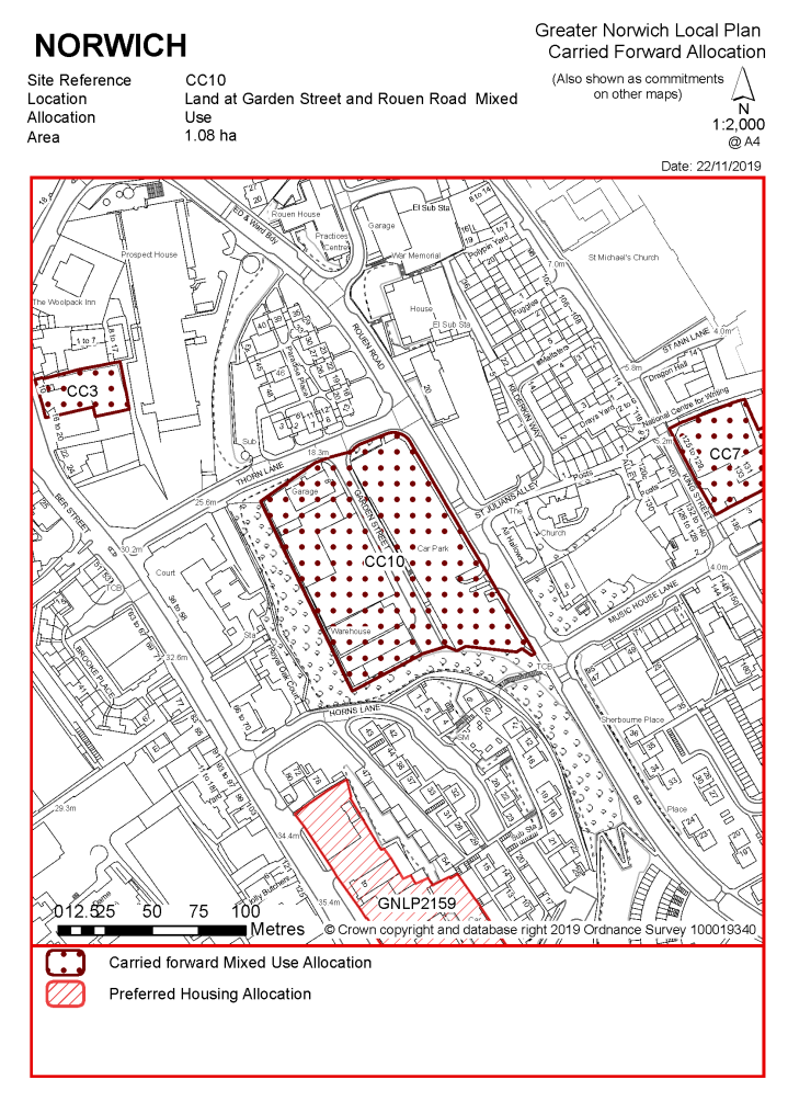
POLICY CC10 Land at Garden Street and Rouen Road, Norwich (approx. 1.08ha) is allocated for mixed use development. This will accommodate approximately 100 homes, of which at least 28 (or 28%) should be affordable. This site could include an element of small-scale office/business units to cater for small business.
The development will achieve the following site-specific requirements:
|
Notes CC10:
The site was allocated in the previous Local Plan for housing but has not yet been developed. A previous option to provide a primary school on the site has not been progressed due to additional school capacity since becoming available in the city centre. The principle of development on the site has already been accepted and it is expected that development will take place later within the time-period of this Local Plan, likely within 10-15 years. The site is re-allocated for mixed use development. As an existing allocation it has been considered in the calculation of the housing requirement.
The site is likely to accommodate at least 100 homes. More may be accommodated, subject to an acceptable design and layout etc. being achieved.
|
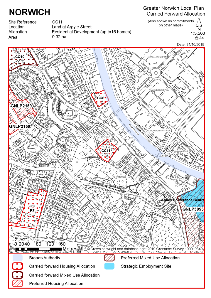
POLICY CC11 Land at Argyle Street, Norwich (approx. 0.32ha) is allocated for residential development. This will accommodate 10-15 homes, of which at least 28% should be affordable.
The development will achieve the following site-specific requirements:
|
Notes CC11:
The site was allocated in the previous Local Plan but has not yet been developed. Demolition of subsidence damaged bungalows previously on the site has been taken account of in the calculation of historic housing delivery. The principle of housing redevelopment on the site has already been accepted, and it is expected that development will take place within the new local plan time-period up to 2038. The site is re-allocated for residential development. As an existing allocation it has been considered in the calculation of the housing requirement.
The site is likely to accommodate between 10 and 15 homes. This will include affordable housing providing a mix of affordable tenures consistent with identified needs at the time of submission of a planning application and subject to viability, but it is expected that as the land is in public ownership the site is capable of delivering a scheme of 100% affordable dwellings.
|
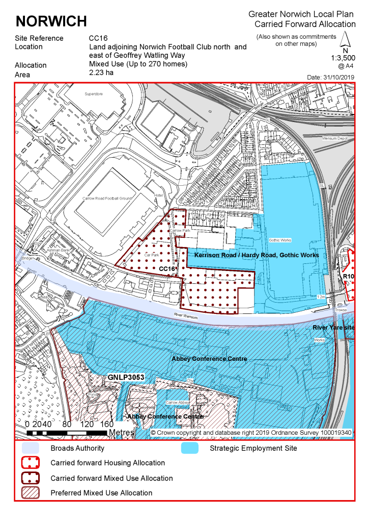
POLICY CC16 Land adjoining Norwich City Football Club north and east of Geoffrey Watling Way, Norwich (approx. 2.23ha) is allocated for mixed use development to include residential, leisure, community, office and ancillary small retail uses. This will accommodate a minimum of 270 homes, of which at least 76 (or 28%) should be affordable.
The development will achieve the following site-specific requirements:
|
Notes CC16:
The site was allocated in the previous Local Plan and the western part of the original allocation at Geoffrey Watling Way has been developed. Much of the remaining land on the river frontage (Carrow Quay) has benefit of planning permission and the first phase of development is underway. Land at the football club car park and Groundsman's Hut site remains appropriate for development; the latter site has now got planning permission for 73 units of housing (Carrow View). The principle of development on the site has already been accepted, and it is expected that development will take place within the new local plan time-period up to 2038. The site is re-allocated for residential development. As an existing allocation it has been considered in the calculation of the housing requirement.
The site is likely to accommodate up to 200 homes on the currently undeveloped part of Carrow Quay site and a minimum of 70 homes on the groundsman's hut/car park site. This will include affordable housing providing a mix of affordable tenures consistent with identified needs at the time of submission of a planning application and subject to viability. More may be accommodated, subject to an acceptable design and layout etc. being achieved.
POLICY CC17a and CC17b Land at Barrack Street/Whitefriars
See Policy GNLP0409R above
|
POLICY CC18 Land at 140-154 Oak Street and 70-72 Sussex Street, Norwich (approx. 0.36ha) is allocated for residential use. This will accommodate a minimum of 27 homes, of which at least 8 (or 28%) should be affordable.
The development will achieve the following site-specific requirements:
|
Notes CC18:
The site was allocated in the previous Local Plan as two separate sites CC18 and CC19 which are now in the same ownership. Neither allocation has yet been developed but the northern part fronting Sussex Street (previously CC19) has a previous unimplemented consent for 17 homes intended to be delivered as a co-housing scheme, with the land fronting Oak Street (CC18) having been allocated for a minimum of 10 homes. The principle of development on the site has already been accepted, and it is expected that development will take place within the new local plan time-period up to 2038. The site is re-allocated for residential development. As an existing allocation it has been considered in the calculation of the housing requirement.
The site is likely to accommodate at least 27 homes. This will include affordable housing providing a mix of affordable tenures consistent with identified needs at the time of submission of a planning application and subject to viability. More may be accommodated, subject to an acceptable design and layout etc. being achieved.
|
POLICY CC24 Land to rear of City Hall, Norwich (approx. 0.40ha) is allocated for mixed use development which may include residential, offices and managed workspace, food and drink and small-scale retail uses. The alternative option of a hotel development is supported and, if this option is progressed, scope for accommodating residential uses on part of the site should be investigated in order to retain its potential for housing delivery. If developed with an element of residential uses the site could accommodate a minimum of 20 homes, of which at least 6 (or 28%) should be affordable.
The development will achieve the following site-specific requirements:
|
Notes CC24:
The site was allocated in the previous Local Plan but has not yet been developed. The principle of development on the site has already been accepted, and it is expected that development will take place within the new local plan time-period up to 2038. The site is re-allocated for mixed-use development. As an existing allocation it has been considered in the calculation of the housing requirement.
The site may accommodate at least 20 homes if developed for a mix of uses including residential. This will include affordable housing providing a mix of affordable tenures consistent with identified needs at the time of submission of a planning application and subject to viability. More may be accommodated, subject to an acceptable design and layout etc. being achieved.
POLICY CC29 Land adjoining and to the west of at Queens Road and Surrey Street, Norwich
See Policy GNLP0451 above.
|
POLICY CC30 Westwick Street Car Park, Norwich (approx. 0.30ha) is allocated for residential development. This will accommodate a minimum of 30 homes, of which at least 8 (or 28%) should be affordable.
The development will achieve the following site-specific requirements:
|
Notes CC30:
The site was allocated in the previous Local Plan but has not yet been developed. The principle of development on the site has already been accepted, and it is expected that development will take place within the new local plan time-period up to 2038. The site is re-allocated for residential development. As an existing allocation it has been considered in the calculation of the housing requirement.
The site is likely to accommodate a minimum of 30 homes. More may be accommodated, subject to an acceptable design and layout etc. being achieved.
|
POLICY R1 Land at The Meatmarket, Hall Road (approx. 4.50 hectare) is allocated for employment development and light industrial use (use classes B2/B8 and B1(c)). Ancillary office development and motor trade/car sales uses on the frontage to Hall Road will also be acceptable.
The development will achieve the following site-specific requirements:
|
The site was allocated in the previous Local Plan for employment development and part of the site is subject to detailed permission for a car sales use. The remainder of the site has not yet been developed. The principle of development on the site has already been accepted, and it is expected that development will take place within the new local plan time-period up to 2038. The site is re-allocated for employment use.
|
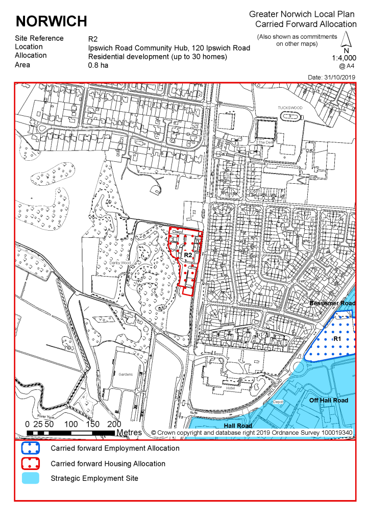
POLICY R2 Ipswich Road Community Hub, 120 Ipswich Road, Norwich (approx. 0.80ha) is allocated for residential development which may be provided either as general needs housing or purpose-built accommodation for older people or people with special needs. Development consolidating and expanding the existing community support and educational facilities on site will also be acceptable. If developed for residential purposes the site is expected to accommodate a minimum of 15 homes, of which at least 5 (or 33%) should be affordable.
The development will achieve the following site-specific requirements:
|
Notes R2:
The site was allocated in the previous Local Plan but has not yet been developed. The principle of development on the site has already been accepted, and it is expected that development will take place within the new local plan time-period up to 2038. The site is re-allocated for residential development with the option of development or redevelopment for community uses. As an existing allocation it has been considered in the calculation of the housing requirement.
The site is likely to accommodate at least 15 homes if developed for residential purposes. This will include affordable housing providing a mix of affordable tenures consistent with identified needs at the time of submission of a planning application and subject to viability.
|
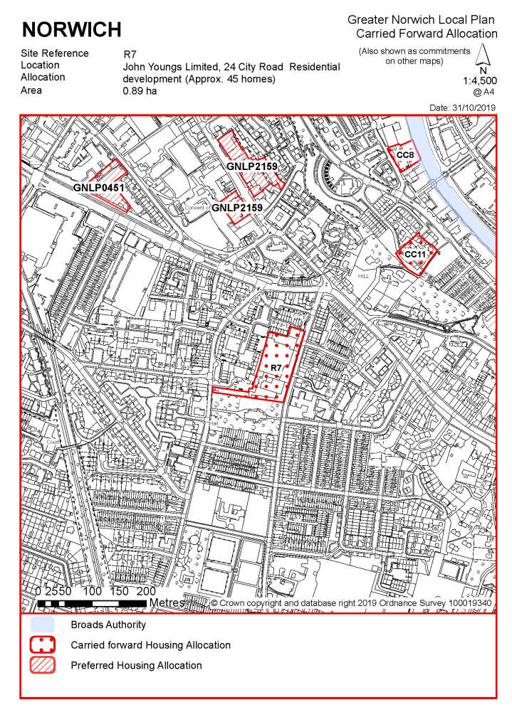
POLICY R7 John Youngs Limited, 24 City Road, Norwich (approx. 0.89ha) is allocated for residential development. This will accommodate a minimum of 45 homes, of which at least 15 (or 33%) should be affordable.
The development will achieve the following site-specific requirements:
|
Notes R7:
The site was allocated in the previous Local Plan but has not yet been developed. The principle of development on the site has already been accepted, and it is expected that development will take place within the new local plan time-period up to 2038. The site is re-allocated for residential development. As an existing allocation it has been considered in the calculation of the housing requirement.
The site is likely to accommodate at least 45 homes. This will include affordable housing providing a mix of affordable tenures consistent with identified needs at the time of submission of a planning application and subject to viability. More may be accommodated, subject to an acceptable design and layout being achieved and the need to have regard to conserving and enhancing the setting of adjoining heritage assets.
POLICY R9 The Deal Ground, Norwich (approx. 8.10ha)
See policy GNLP0360 above
|
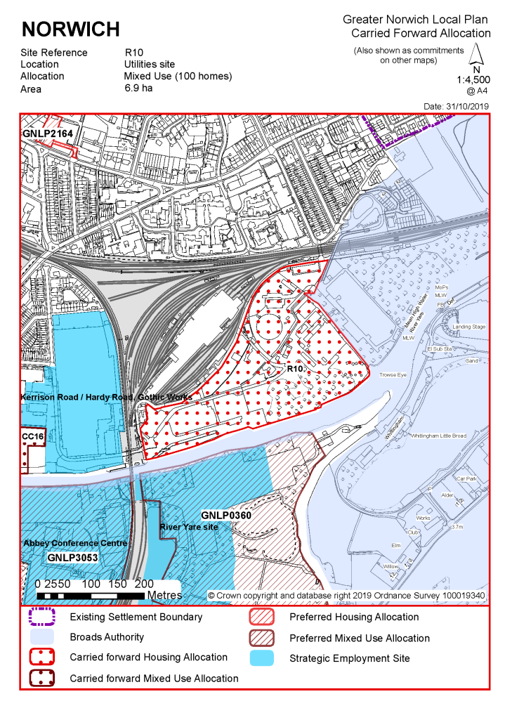
POLICY R10 Utilities site, Norwich (approx. 6.90ha) is allocated for residential led mixed-use development including housing, community, education and leisure facilities, local employment, local greenspace, biodiversity areas and recreational open space as part of a balanced mix, together with all necessary supporting vehicular, pedestrian, cycle and public transport access infrastructure. The site is expected to accommodate a minimum of 100 homes subject to confirmation through detailed masterplanning of the wider East Norwich Strategic Regeneration Area as defined in policy 7.1 of this plan (which in total is expected to deliver a minimum of 2000 homes, of which at least 33% should be affordable).
The development will achieve the following site-specific requirements:
|
Notes R10:
The site was allocated in the previous Local Plan but has not yet been developed. Previous proposals were founded on the expectation of delivering a renewable power generation facility as an integral part of the development and although this option is not being actively pursued there is scope for local energy generation serving the wider area which is reflected in policy 7.1. The principle of development on the site has already been accepted and it is expected that development will take place within the time-period of this Local Plan. The site is re-allocated for mixed use development. As an existing allocation it has been considered in the calculation of the housing requirement.
The site is likely to accommodate at least 100 homes contributing to an overall target of 2000 in the East Norwich strategic regeneration area. This will include affordable housing providing a mix of affordable tenures consistent with identified needs at the time of submission of a planning application and subject to viability. More housing may be accommodated, subject to an acceptable design and layout being achieved and contingent on the scope for enhanced infrastructure provision and increased highway network capacity in the area.
Note: The Utilities site is split between Norwich City and the Broads Authority Executive Area for planning purposes: the land immediately to the east of site R10 between the River Yare and the railway line falls within the planning jurisdiction of the Broads Authority. Policy NOR1 of the adopted Broads Local Plan 2019 (or successor document) provides for mixed use development of this adjoining land potentially providing up to 120 homes in addition to the housing potential of the site allocated within this plan. Development proposals will need to incorporate both areas and are required to comply with the site-specific policies of both local planning authorities.
|
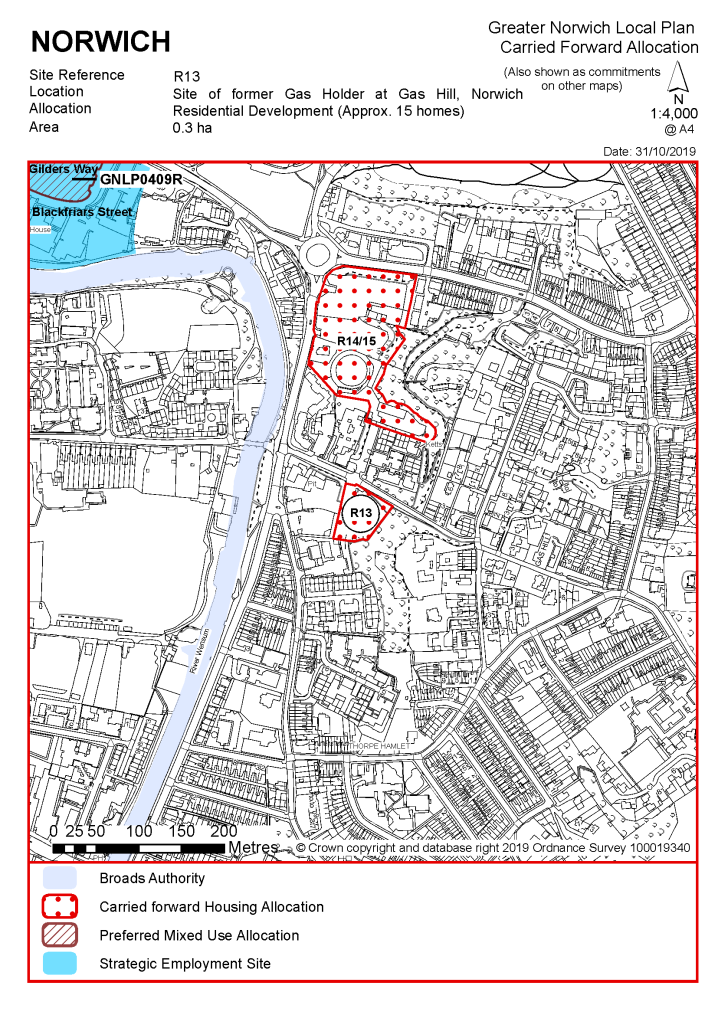
POLICY R13 Site of former Gas Holder at Gas Hill, Norwich (approx. 0.30ha) is allocated for residential development. This will accommodate a minimum of 15 homes, of which at least 5 (or 33%) should be affordable.
The development will achieve the following site-specific requirements:
|
Notes R13:
The site was allocated in the previous Local Plan but has not yet been developed. The gas holder previously on site has been decommissioned and removed. The principle of development on the site has already been accepted, and it is expected that development will take place within the new local plan time-period up to 2038. The site is re-allocated for residential development. As an existing allocation it has been considered in the calculation of the housing requirement.
The site is likely to accommodate at least 15 homes. This will include affordable housing providing a mix of affordable tenures consistent with identified needs at the time of submission of a planning application and subject to viability. More housing may be accommodated, subject to an acceptable design and layout being achieved.
|
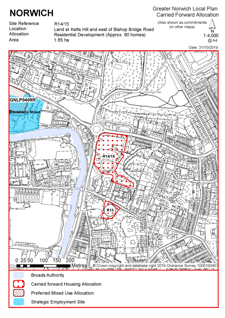
POLICY R14/R15 Land at Ketts Hill and east of Bishop Bridge Road, Norwich (approx. 1.65ha) is allocated for residential development. This will accommodate a minimum of 80 homes, of which at least 26 (or 33%) should be affordable. Site R15 combined with R14 as a single allocation.
The development will achieve the following site-specific requirements:
|
Notes R14/R15:
The site was previously identified as two separate allocations in the adopted 'Site allocations and site-specific policies' plan, site R14 (Land East of Bishop Bridge Road) and R15 (Land at Ketts Hill and Bishop Bridge Road). The constraint on development imposed by the gasholder on the southern part has now been released following its demolition, subject to revocation of the hazardous substance consent. The site has not yet been developed. The principle of residential development on the land has already been accepted and it is expected that development will take place within the time-period of this Local Plan. The sites are accordingly re-allocated for residential development as a single allocation for a similar number of homes. The potential contribution from the previous allocations has been considered in the calculation of the housing requirement.
The site is likely to accommodate a minimum of 80 homes. This will include affordable housing providing a mix of affordable tenures consistent with identified needs at the time of submission of a planning application and subject to viability. More may be accommodated, subject to an acceptable design and layout etc. being achieved.
|
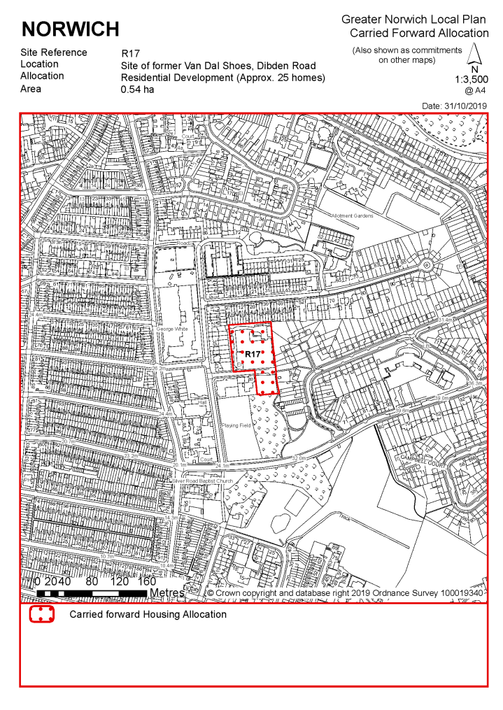
POLICY R17 Site of former Van Dal Shoes, Dibden Road, Norwich (approx. 0.54ha) is allocated for residential development. This will accommodate a minimum of 25 homes, of which at least 8 (or 33%) should be affordable.
The development will achieve the following site-specific requirements:
|
Notes R17:
The site was allocated in the previous Local Plan but has not yet been developed. The principle of development on the site has already been accepted, and it is expected that development will take place within the new local plan time-period up to 2038. The site is re-allocated for residential development. As an existing allocation it has been considered in the calculation of the housing requirement.
The site is likely to accommodate at least 25 homes. This will include affordable housing providing a mix of affordable tenures consistent with identified needs at the time of submission of a planning application and subject to viability. More may be accommodated, subject to an acceptable design and layout etc. being achieved.
|
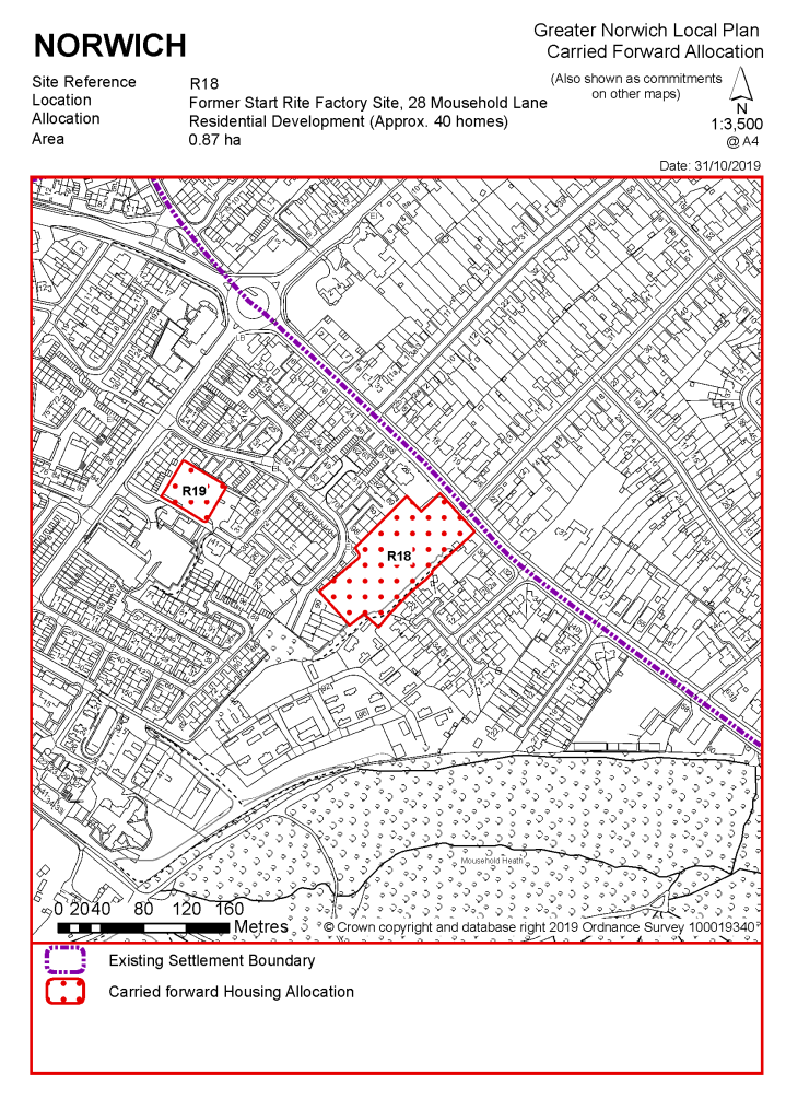
POLICY R18 Site of former Start Rite Factory, 28 Mousehold Lane, Norwich (approx. 0.87ha) is allocated for residential development. This will accommodate a minimum of 40 homes, of which at least 13 (or 33%) should be affordable.
The development will achieve the following site-specific requirements:
|
Notes R18:
The site was allocated in the previous Local Plan but has not yet been developed. The principle of development on the site has already been accepted, and it is expected that development will take place within the new local plan time-period up to 2038. The site is re-allocated for residential development. As an existing allocation it has been considered in the calculation of the housing requirement.
The site is likely to accommodate a minimum of 40 homes. This will include affordable housing providing a mix of affordable tenures consistent with identified needs at the time of submission of a planning application and subject to viability. More may be accommodated, subject to an acceptable design and layout etc. being achieved.
|
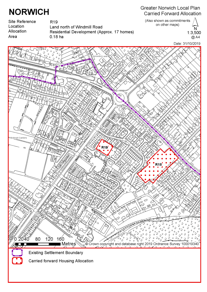
POLICY R19 Land north of Windmill Road, Norwich (approx. 0.18ha) is allocated for residential development. This will accommodate in the region of 17 homes, of which at least 6 (or 33%) should be affordable.
The development will achieve the following site-specific requirements:
|
Notes R19:
The site was allocated in the previous Local Plan and has been subject to planning permission for a development of 17 homes which has not been implemented. The principle of development on the site has already been accepted, and it is expected that development will take place within the new local plan time-period up to 2038. The site is re-allocated for residential development providing a comparable number of homes to the approved scheme. As an existing allocation with valid permission at the base date of the plan it has been considered in the calculation of the housing requirement.
The site is likely to accommodate in the region of 17 homes. Development of the site will include a contribution to affordable housing in accordance with Policy 5, providing a mix of affordable tenures consistent with identified needs at the time of submission of a planning application and subject to viability.
|
POLICY R20 Land east of Starling Road, Norwich (approx. 0.27ha) is allocated for residential development. This will accommodate a minimum of 23 homes, of which at least 8 (or 33%) should be affordable.
The development will achieve the following site-specific requirements:
|
Notes R20:
A larger site including land immediately to the north was allocated in the previous Local Plan for 45 homes. This has been partially delivered with the completion of 22 apartments on the former Cordova Buildings site. The remaining part of the allocation in two land parcels east of Starling Road has been subject to previous outline and detailed planning permissions for housing development but neither permission has been implemented. The principle of development on the remaining part of the original allocation has already been accepted, and it is expected that development will take place within the new local plan time-period up to 2038. The site is re-allocated for residential development to deliver a number of homes equivalent to the capacity of the remaining land. As an existing partially undeveloped allocation it has been considered in the calculation of the housing requirement.
The site is likely to accommodate at least 23 homes. Development of this site will include affordable housing in accordance with Policy 5, providing a mix of affordable tenures consistent with identified needs at the time of submission of a planning application and subject to viability. More may be accommodated, subject to an acceptable design and layout etc. being achieved.
|
POLICY R29 Two sites at Hurricane Way, Airport Industrial Estate, Norwich (Site A, land north of Gamecock Close and west of 6-14 Hurricane Way, (approx. 0.26 ha) and Site B, land between Hurricane Way and Stirling Road, (approx. 2.00 ha) ) are allocated for residential led mixed use development. This will accommodate a minimum of 30 homes, of which at least 10 (or 33%) should be affordable.
The development will achieve the following site-specific requirements:
|
Notes R29:
The site was allocated in the previous Local Plan but has not yet been developed. The principle of development on the site has already been accepted, and it is expected that development will take place within the new local plan time-period up to 2038. The scope for residential development on part of the site is acknowledged provided this can be delivered without resulting in unacceptable impacts on residential occupiers from existing or proposed employment uses. As an existing allocation it has been considered in the calculation of the housing requirement.
The site is likely to accommodate at least 30 homes. This will include affordable housing providing a mix of affordable tenures consistent with identified needs at the time of submission of a planning application and subject to viability. More may be accommodated, subject to an acceptable design and layout etc. being achieved.
|
Policy R30: Land at Holt Road, Norwich (approx. 2.17ha) is allocated for general employment purposes (use classes B1b/c, B2 and B8).
The development will achieve the following site-specific requirements:
|
Notes R30:
This site was previously allocated in the Norwich Site Allocations and Site-Specific Policies plan for either:
- an extension to the airport, where justified in an airport masterplan produced and endorsed by Norwich City Council within two years from adoption of that plan (by December 2016), or
- for general employment uses.
A masterplan for Norwich Airport masterplan was not produced within that time period.
A masterplan has subsequently been produced and was endorsed by the city council In October 2019. This does not identify the land at Holt Road as required for airport related uses.
The site comprises 3 paddocks and is understood to be in multiple ownership. Part of the site has outline planning consent for vehicle hire.
|
POLICY R31 Heigham Water Treatment Works, Waterworks Road, Norwich (approx. 5.00ha) is allocated for housing led mixed use development and public open space. This will accommodate a minimum of 150 homes, of which at least 50 (or 33%) should be affordable.
The development will achieve the following site-specific requirements:
|
Notes R31:
This part of the water treatment works is identified as surplus to Anglian Water's operational needs and is planned to be decommissioned. The site was allocated in the previous Local Plan but has not yet been developed. The principle of development on the site has already been accepted, and it is expected that development will take place within the new local plan time-period up to 2038. The site is re-allocated for residential-led mixed use development and public open space. As an existing allocation it has been considered in the calculation of the housing requirement.
The majority of the site is within flood zone 2, whilst a small part of the site is in flood zone 3a. A site-specific flood risk assessment will need to be completed prior to the planning application stage. The area falling within flood zone 3a must not be developed for housing; instead, it should be included in the landscaping and open space provision. Since the site is over 1 hectare, a flood risk assessment is required, and appropriate mitigation measures should be provided as part of the development.
Development of the site will only be possible subsequent to decommissioning and will require consultation with the Health and Safety Executive. Development should take into account possible site contamination.
This site is a regionally important "industrial garden", as identified by the Norfolk Historic Gardens Survey. An archaeological survey is required before any development takes place and the design of the development should seek to retain the special characteristics of the site. Three buildings on site, Eastgate House, Pump House 1 and Pump House 2, are locally listed; these should be retained for re-use or converted to residential uses.
The site is likely to accommodate at least 150 homes. Development of this site will include affordable housing in accordance with policy 5, providing a mix of affordable tenures consistent with identified needs at the time of submission of a planning application and subject to viability. More homes may be accommodated, subject to an acceptable design and layout etc. being achieved.
|
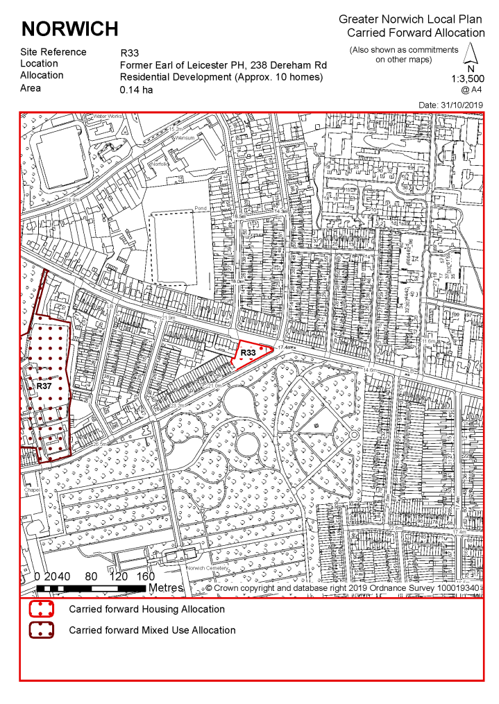
POLICY R33 Site of former Earl of Leicester Public House, 238 Dereham Road, Norwich (approx. 0.14ha) is allocated for residential development. This will accommodate in the region of 10 homes, of which at least 3 (or 33%) should be affordable.
The development will achieve the following site-specific requirements:
|
The site was allocated in the previous Local Plan and has been subject to a previous planning permission scheme but has not yet been developed. The principle of development on the site has already been accepted, and it is expected that development will take place within the new local plan time-period up to 2038. The site is re-allocated for residential development. As an existing allocation it has been considered in the calculation of the housing requirement.
The site is likely to accommodate in the region of 10 homes. Development of this site will include affordable housing in accordance with policy 5, providing a mix of affordable tenures consistent with identified needs at the time of submission of a planning application and subject to viability.
|
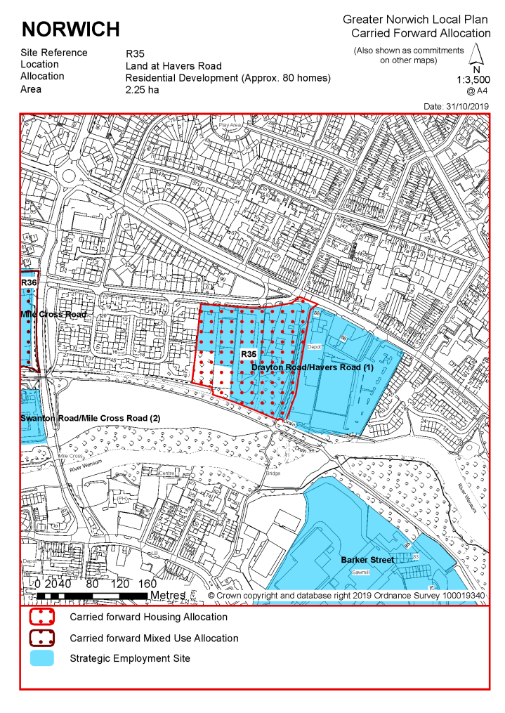
POLICY R35 Land at Havers Road, Norwich (approx. 2.25ha) is allocated for residential development. This will accommodate in the region of 80 homes, of which at least 26 (or 33%) should be affordable.
The development will achieve the following site-specific requirements:
|
Notes R35:
The site was allocated in the previous Local Plan but has not yet been developed. The principle of development on the site has already been accepted, and it is expected that development will take place within the new local plan time-period up to 2038. The site is re-allocated for residential development. As an existing allocation it has been considered in the calculation of the housing requirement.
The site is likely to accommodate in the region of 80 homes. Development of this site will include affordable housing in accordance with policy 5, providing a mix of affordable tenures consistent with identified needs at the time of submission of a planning application and subject to viability. More may be accommodated, subject to an acceptable design and layout etc. being achieved.
The site is partially in Flood Zone 2 and is over 1 hectare in size. Therefore, a flood risk assessment is required for this site and appropriate mitigation measures must be provided as part of the development.
|
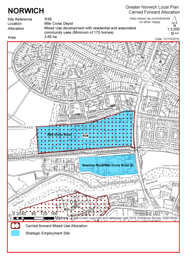
POLICY R36 Mile Cross Depot, Norwich (approx. 3.65ha) is allocated for mixed use development with residential and associated community uses. This will accommodate a minimum of 170 homes, of which at least 56 (or 33%) should be affordable.
The development will achieve the following site-specific requirements:
|
Notes R36:
The site was allocated in the previous Local Plan for a mixed-use development of up to 75 homes and employment uses. Current aspirations on this Council-owned site are to deliver a residential-led scheme with a substantially increased number of homes, alongside associated community uses. The principle of development on the site has already been accepted, and it is expected that development will take place within the new local plan time-period up to 2038. As an existing allocation it has been considered in the calculation of the housing requirement.
The site is likely to accommodate a minimum of 170 homes. Development of this site will include affordable housing in accordance with policy 5, providing a mix of affordable tenures consistent with identified needs at the time of submission of a planning application and subject to viability. More may be accommodated, subject to an acceptable design and layout etc. being achieved, dependant on the mix of uses and geological constraints being overcome.
|
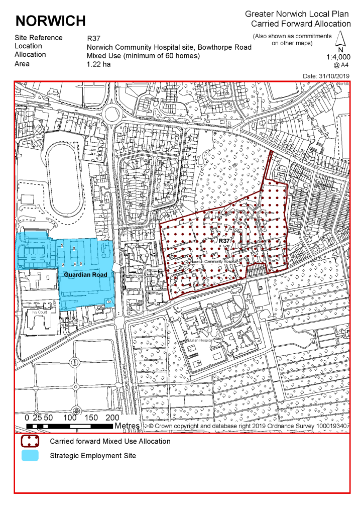
POLICY R37 The Norwich Community Hospital site, Bowthorpe Road, Norwich (approx. 5.27 ha) is allocated for hospital development and ancillary activities, plus associated supported living, care and key worker accommodation, and residential development. This will accommodate a minimum of 80 homes, or equivalent, including 26 (or 33%) units of affordable housing.
The development will achieve the following site-specific requirements:
|
Notes R37:
Part of this site was allocated in the previous Local Plan for 80 homes in the expectation that it would be disposed of for development as part of the future rationalisation and redevelopment of the hospital. Although these redevelopment plans are still being progressed, the area of land considered surplus to NHS requirements has been reassessed and part of the original local plan allocation site is now identified for continued healthcare use under proposals since granted outline planning permission. Proposals for redevelopment of the main part of the hospital site make provision for key worker housing and housing for older people which is expected to address part of the housing need originally to have been met from the development of the local plan allocation site. The site has not yet been developed. The principle of development on the site has already been accepted, and it is expected that development will take place within the new local plan time-period up to 2038. The site is re-allocated on a larger boundary for a mix of uses including residential development which will be subject to review depending on evidence of needs provided by the NHS Trust. As an existing allocation it has been considered in the calculation of the housing requirement.
The site is likely to accommodate at least 80 homes.
|
POLICY R38 Three Score, Bowthorpe, Norwich (approx. 25.29ha) is allocated for an urban extension including housing, open and play space and associated infrastructure. This will accommodate in the region of 900 homes to provide affordable housing in accordance with policy 5, subject to viability considerations.
The development will achieve the following site-specific requirements:
|
Notes R38:
The site was allocated in the previous Local Plan for residential-led mixed-use development and is being developed in accordance with an approved masterplan. The site will deliver approximately 1000 homes as provided for in the outline planning permission. Development of the north-eastern part of the original allocation south of Clover Hill Road is being progressed and is partly complete. The remaining undeveloped phases of Three Score have the potential to deliver approximately 900 homes under current planning consents. Development of the rest of Three Score is expected to take place within the time-period of this Local Plan. The site is re-allocated for residential-led mixed use development including open space. As an existing allocation it has been considered in the calculation of the housing requirement.
The site is likely to accommodate in the region of 900 homes. This will include affordable housing providing a mix of affordable tenures consistent with identified needs at the time of submission of a planning application and subject to viability. More may be accommodated, subject to an acceptable design and layout etc. being achieved.
POLICY R39 Land adjoining the Enterprise Centre, Earlham Hall
See GNLP0133-B above.
POLICY R40 Land north of Cow Drive (the Blackdale Building, adjoining Hickling House and Barton House, University of East Anglia (previously Former Blackdale School)
See GNLP0133-C above
POLICY R41 Land between Suffolk Walk and Bluebell Road
See GNLP0133-above
|
POLICY R42 Land west of Bluebell Road, and north of Daisy Hill Court/Coralle Court, Westfield View, Norwich, (approx. 3.44ha) is allocated for residential development for older people (over 55s). This will accommodate up to 60 homes and/or elderly care accommodation planned as an extension to the existing development, to provide affordable housing contribution in accordance with policy 5, subject to viability considerations.
The development will achieve the following site-specific requirements:
|
Notes R42:
The site was allocated in the previous Local Plan and has been partially developed with 62 retirement apartments (20 of them affordable) and 58 supported care units. The principle of development on the remaining phases of the site has already been accepted through the previous local plan allocation which secures public recreational use and long-term maintenance and management of the open space immediately to the north. It is expected that development will take place within the new local plan time-period up to 2038. The site is re-allocated for residential development for older people. As an existing allocation it has been considered in the calculation of the housing requirement.
The site is likely to accommodate up to 60 homes. This will include affordable housing contribution consistent with identified needs at the time of submission of a planning application and subject to viability. More may be accommodated, subject to an acceptable design and layout etc. being achieved.
|
Address |
Site Reference |
Area (ha) |
Promoted for |
Reason for not allocating |
|
Norwich |
||||
| (2) | ||||
|
Land east of King Street (King Street Stores & Sports Hall site) |
GNLP0377 |
0.33 |
Residential development for a minimum of 40-50 dwellings with re provision of existing sports facility/centre |
In the absence of evidence that the sports hall is surplus to requirements or any detailed information on how it might be replaced or re-provided allocation of the whole site would be premature and contrary to emerging policy. Existing allocation CC8 on the King Street Stores site only is suitable to carry forward in isolation and any future proposals to develop the sports hall could be progressed through a planning application. |
|
Norwich Airport Park & Ride |
GNLP0381 |
3.40 |
Redevelopment of site for small scale retail/food store, hotel, business/office use or mixed-use development |
There is no requirement for the development proposed and no basis for the release of the Park and Ride site pending decisions on its replacement and the form of the future Park and Ride network in the context of the ongoing Transport for Norwich strategy review. However, once these decisions are clarified the site would be appropriate for release. |
|
Site of Former Church, Heartsease Lane |
GNLP0570 |
2.44 |
Residential as an alternative to church redevelopment |
Site was previously a private sports club and most recently a (now demolished) place of worship. Site could be appropriate for a carefully designed and integrated housing development although proposals for redevelopment as a church with no residential element have recently been approved. Given the uncertainty over whether any housing is likely to be deliverable, the site is a reasonable alternative but is not preferred for allocation at the current time. |
| (2) | ||||
|
Land at Riverside |
GNLP2137 |
11.68 |
Mixed use development including residential offices, increased leisure and recreational activities, hotels and retail |
A more permissive and flexible policy is being taken forward for the city centre as a whole which should allow for diversification of uses and intensification of development. This site is considered to be a reasonable alternative but in the absence of further evidence on the precise form of development and the quantum of housing which might be deliverable a specific allocation is not considered appropriate at the current time. |
|
Sainsbury Homebase Site, Hall Road Retail Park |
GNLP3050 |
2.28 |
Residential |
Development solely for residential purposes would result in an awkward and inappropriate relationship with neighbouring uses however site is considered to be a reasonable alternative to allow development potential to be assessed in the context of options for the retail park as whole but is not preferred for allocation. Current proposals to retain the retail use and subdivide the unit will mean that the site is now unlikely to come forward for alternative forms of development. |
|
Address |
Site Reference |
Area (ha) |
Promoted for |
Reason considered to be unreasonable |
|
Norwich |
||||
|
293-297 Aylsham Road |
GNLP0117 |
1.20 |
Retail development including supermarket/ food store |
The proposed foodstore has been implemented and is open for trading |
|
|
||||
|
UEA - University Drive North |
GNLP0133A |
1.58 |
Additional Sport Park related development e.g. new sports pitches, car parking and ancillary uses |
Development would be likely to have significant impacts on protected green space, green infrastructure and ecological networks. |
|
|
||||
| (1) | ||||
|
UEA – Land west of Bluebell Road |
GNLP0133F |
5.72 |
University related development e.g. teaching, research, accommodation, general infrastructure and ancillary uses |
Development would be likely to have significant impacts on protected green space, green infrastructure and ecological networks. |
|
|
||||
| (1) | ||||
|
Dowding Road |
GNLP0523 |
0.37 |
Residential development of up to 10 new dwellings |
Site too small to meet the minimum allocation requirement and would involve the loss of protected open space |
|
|
||||
| (1) | ||||
|
Wensum Lodge, 169 King Street |
GNLP1011 |
0.26 |
Allocation to protect continued use a community sports facility |
This proposal involves no substantive development and protection of individual community facilities is not a matter for the GNLP. Better considered in the context of a review of DM policies. Wensum Sports Hall site is not proposed to be allocated in the absence of evidence to demonstrate that the facility is surplus to requirements or a that a mechanism exists to replace or re-provide the sports facility elsewhere. |
|
|
||||
| (2) | ||||
|
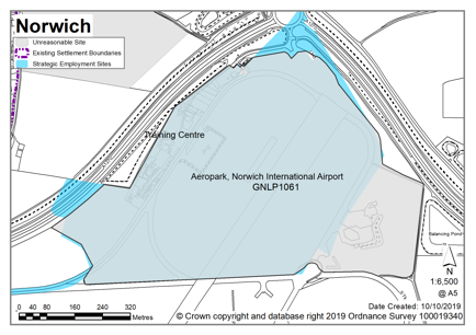
Imperial Park (formerly site 4), Norwich Airport (Partly within Broadland – Horsham St Faith Parish) |
GNLP1061 |
46.50 |
General employment floorspace (B1c, B2, B8 and D1 with ancillary A1-A3 Use Classes) |
The site falls within the operational area of Norwich Airport. Proposals for aviation related uses have been approved in outline but are not being progressed and this proposal seeks a reallocation for general employment use, which is also being pursued through a planning application. There is no evidence of need for new general employment allocations and the opportunity to deliver a major aviation related facility as consented would bring significant economic benefits |
|
|
||||
|
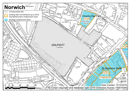
Chapelfield |
GNLP2077 |
3.66 |
Additional town centre uses including retail (A1), Leisure (D2) and food and drink (A3) |
This proposal does not involve any substantive development but seeks a more flexible approach to the acceptance of uses in the shopping centre. More appropriate to consider in the context of the city centre policy and future review of DM policies. |
|
|
||||
|
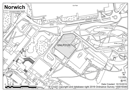
Congregation Hall, UEA |
GNLP2120 |
0.33 |
Conference Centre |
As a redundant building within the existing designated UEA campus, proposals for a conference centre could be considered through the specific DM policy for the campus or any equivalent successor policy. |
|
|
||||
|
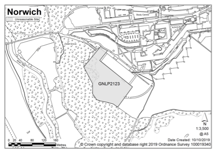
Adjoining Sainsbury Centre, UEA |
GNLP2123 |
1.60 |
University related development possibly expansion of Sainsbury Centre |
Development would be likely to have significant impacts on protected green space, green infrastructure and ecological networks. |
|
|
||||
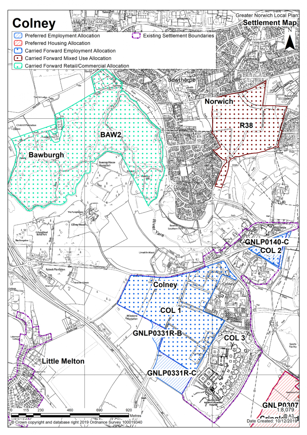
COLNEY (Strategic Employment Area)
Colney is a small village, but the parish is a strategic employment location in the urban fringe, including parts of the Norwich Research Park (NRP), the Norfolk & Norwich University Hospital (NNUH) and Spire hospital. Colney is situated on the B1108 close to the A47. The River Yare forms the parish boundary with Norwich City, therefore some areas are prone to fluvial and surface water flood issues and ecological sensitivity. The parish is also partially covered by landscape policies protecting the setting of the A47 Norwich Southern Bypass and the river valley landscape, as well as being a gateway to the city.
The strategic objective is to reinforce the continued growth of the NRP. Whilst the allocations cover land adjacent to the existing NRP institutes and the NNUH, the 'wider NRP' makes refence to the relationship with the adjoining University of East Anglia campus.
The policies limit uses primarily to Use Class B1(b) i.e. research and development, studios, laboratories and high tech, plus hospital related development. Ancillary and complementary uses will also be acceptable, so long as they are supportive of and essential to the core functions of the NRP and remain ancillary. Potential uses include: recuperative and respite care; education and training facilities; conference facilities for knowledge transfer; short stay accommodation; cafes/restaurants; and supporting business infrastructure e.g. legal and banking services. General offices, manufacturing, storage, distribution and other uses not connected with research and development will not be acceptable.
Colney is part of the catchment for Little Melton Primary School, but it is geographically separated from Little Melton by the A47, and consequently housing potential is likely to be limited. There are no sites identified as preferred options for residential development in Colney. There are no carried forward allocations but a total of 4 additional dwellings with planning permission on small sites. This gives a total deliverable housing commitment for Colney of 4 homes between 2018 – 2038.
All new and carried forward allocations are expected to address standard requirements associated with development. These vary from place to place, but are likely to include mitigations for flood risk (as well as SUDs), highways improvements, safeguarding of minerals resources, land remediation, measures to protect the environment, biodiversity, and landscape intrusion.
|
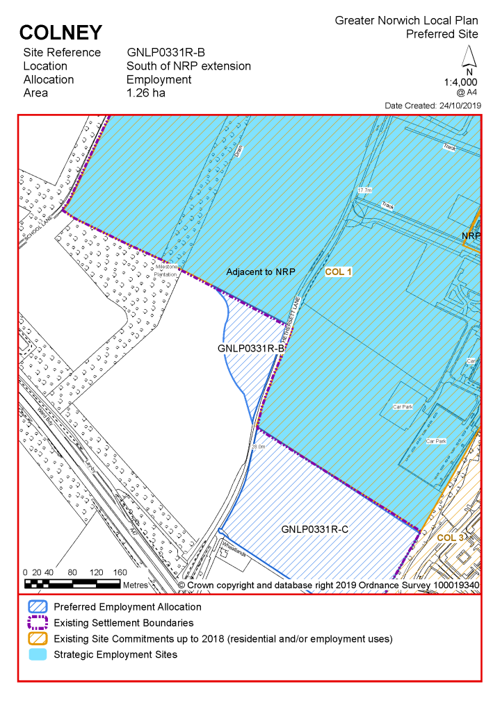
South of Norwich Research Park extension, GNLP0331R-B, 1.26 ha, for a B1(b) Science Park development, hospital expansion and other proposals ancillary and complementary to these main uses. Planning applications will be considered positively for the above uses subject to meeting the criteria set out in Policy COL1.
|
Notes
GNLP0331R-B: This site is preferred for allocation to allow additional capacity up to 2038 for the continued growth of the allocated science park and hospital expansion proposals in the South Norfolk Local Plan (allocation reference COL 1).
|
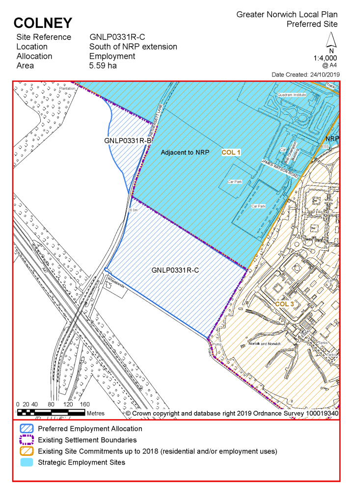
South of Norwich Research Park extension, GNLP0331R-C, 5.59 ha, for B1(b) Science Park development, hospital expansion and other proposals ancillary and complementary to these main uses. Planning applications will be considered positively for the above uses subject to meeting the criteria set out in Policy COL1.
|
Notes
GNLP0331R-C: The site is preferred allowing capacity up to 2038 for continued growth of the allocated science park and hospital expansion in South Norfolk Site Allocations DPD 2015, reference COL1.
Existing allocations to be carried forward:
|
POLICY COL 1 Land adjacent to Norwich Research Park (NRP), Colney (approx. 39.4 ha) is allocated principally for a B1(b) Science Park development, hospital expansion and other proposals ancillary and complementary to these main uses.
The development will be expected to address the following specific matters: Uses
Master plan/infrastructure plan
Transport Measures which address the impacts of the proposed development, including where appropriate:
Design and Landscape
Constraints
|
Notes
COL 1: The site was allocated in 2015 as part of the current local plan. Science park and hospital related uses remain appropriate, and COL 1 is re-allocated.
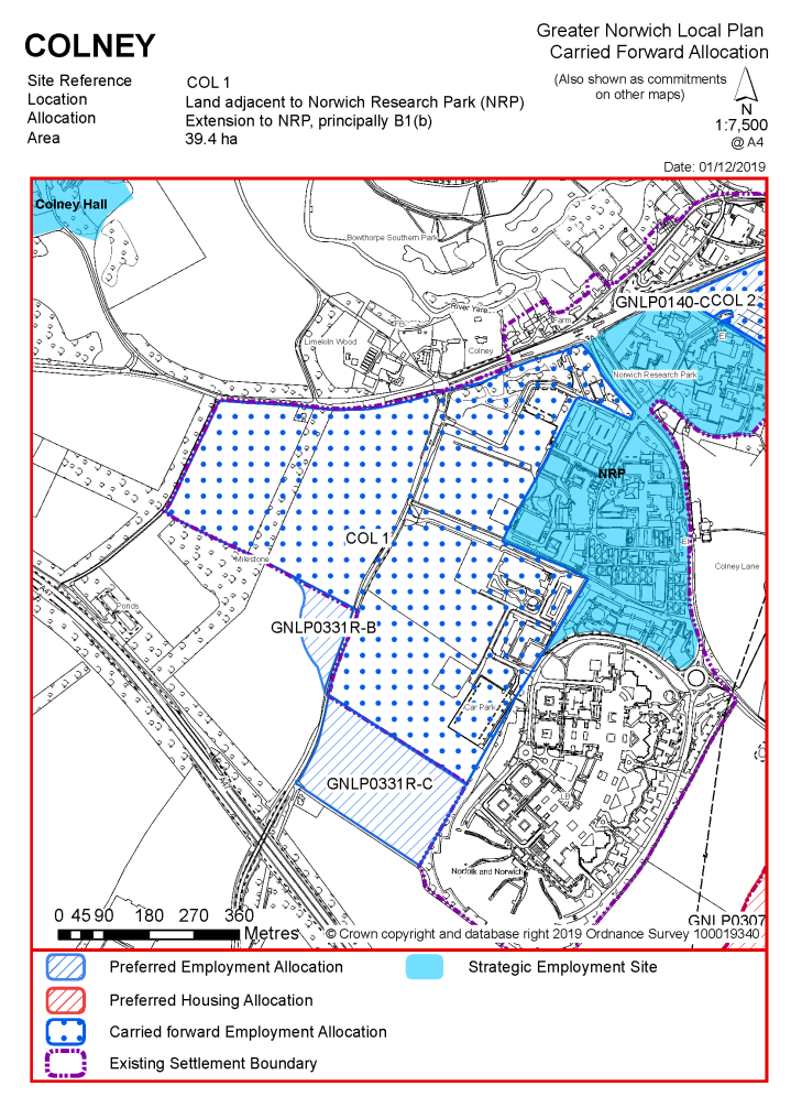
|
POLICY COL 2 / GNLP0140-C Land rear/east of Institute of Food Research (IFR), Colney (approx. 3.7 ha) is allocated principally for a B1(b) Science Park development, hospital expansion and other proposals ancillary and complementary to these main uses. Planning applications will be considered positively for the above uses subject to meeting the criteria set out in Policy COL1 |
Notes
COL 2 (GNLP0140-C): This site is the same as existing allocation COL2 from the South Norfolk Local Plan. COL2 is allocated for science park development, hospital expansion or other development which would complement these uses. Site GNLP0140-C seeks to maintain this allocation for these uses in the new local plan to 2038.
|
POLICY COL 3 Redevelopment of existing hospital and science park uses within the Colney Development Boundary, Colney
Any proposed redevelopment of sites currently in use for Hospital and Science Park development will be considered positively where it accords with the criteria set out in Policy COL 1, to the extent that is proportionate to the scale and nature of the proposal.
|
Notes
COL 3: The development boundary of Colney was defined in 2015 as part of the previous local plan and seeks to guide the range of uses permitted. Retention of the development boundary and policy to guide the uses permitted is considered justified. Policy COL 3 protects the science and hospital activities in this location and ensures the range of uses taking place at Norwich Research Park are compatible with each other.
|
POLICY BAW 2 Bawburgh and Colney Lakes (approx. 73.5ha) is allocated for a water-based country park.
The development will be expected to address the following specific matters:
|
Notes
BAW 2: This site was allocated in the previous 2015 local plan but has not yet been developed. The principle of development on the site has already been accepted and it is expected that development will take place within the time-period of this local plan.
|
Address |
Site Reference |
Area (ha) |
Promoted for |
Reason for not allocating |
|
Colney |
||||
|
NO REASONABLE ALTERNATIVE SITES
|
||||
Unreasonable Sites - Residential
|
Address |
Site Reference |
Area (ha) |
Promoted for |
Reason considered to be unreasonable |
|||||||
|
Colney |
|||||||||||
|
Land at Hall Farm, Watton Road, Colney |
GNLP0158 |
2.92 |
Residential (unspecified number) |
This site is located north of the B1108 in the river valley. It is considered to be unreasonable for allocation due its relative remoteness and poor relationship with the form and character of existing development. There is no safe walking route to Little Melton Primary School, over 3km away, and due to the distance, it would not be feasible or viable to provide one. |
|||||||
|
|
|||||||||||
| (1) | |||||||||||
|
Colney Hall, Watton Road, Colney |
GNLP0253 |
26.30 |
Mixed-use residential development, proposed for 200 retirement properties, an associated facility for life-long learning and support, and a well-being therapy centre. |
Currently there is no detailed evidence to quantify the need for retirement housing per se, although the County Council's strategy Living Well – Homes for Norfolk identifies a need for 2,842 additional extra care units in the county by 2028. There are no definite site-specific proposals yet promoted by an extra care housing provider, and so a generally supportive policy of allowing extra care housing in sustainable locations is the preferred policy approach through the GNLP. |
|||||||
|
|
|||||||||||
| (2) | |||||||||||
|
Old Watton Road, Colney |
GNLP0514 |
0.59 |
Residential (unspecified number) |
This site is located off the Old Watton Road, adjoining the River Yare in the river valley. Despite its location near to existing housing in Colney it is remote from services and facilities and there is currently no settlement limit. Development in this location would encroach on the open character of the river valley. The site has significant trees, so development would harm landscape character. In addition, the northern section of the site is within flood zone 3 with identified surface water flood issues. There is no safe walking route to Little Melton Primary School over 3km away, and due to the distance, it would not be feasible or viable to provide one. It is recognised that the site is closer to schools in Bowthorpe, with a potential safe route, but these are still over 2km away and are not the catchment school. |
|||||||
|
|
|||||||||||
|
32 Watton Road, Colney |
GNLP0592 |
2.99 |
Residential development of an unspecified number or continuation of the Research Park. |
This site is located some distance to the west of Colney south of the B1108 towards the junction with the southern bypass. It is wholly within the southern bypass landscape protection zone. It is considered to be unreasonable for allocation due its relative remoteness and poor relationship with the form and character of existing development. There is no safe walking route to Little Melton Primary School, and due to the distance, it would not be feasible or viable to provide one. |
|||||||
|
|
|||||||||||
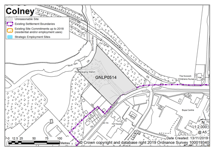
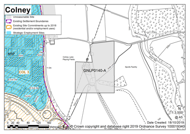
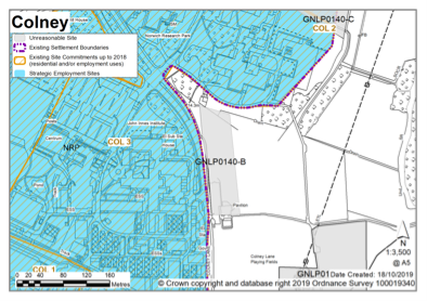
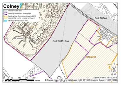
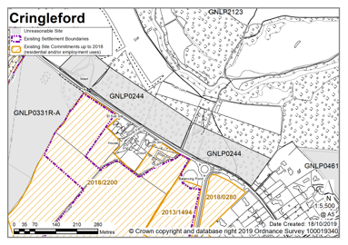
Costessey has one of the largest populations in South Norfolk, having seen significant amounts of development in recent years, and includes one of Greater Norwich's strategic employment locations at Longwater. Costessey includes a number of distinct areas. The valley of the River Tud divides Old Costessey and Queens Hills from New Costessey, helping maintain the separate identities of these settlements. Old Costessey has a strong historic character with Conservation Areas covering key areas and features. Narrow streets and historic buildings edging the road limit the potential to accommodate extra traffic.
To the north the River Wensum is a designated Special Area of Conservation (SAC) and contains a number of Sites of Special Scientific Interest (SSSI) and County Wildlife Sites (CWS). Areas of tree belt characterise the landscape and notable parcels of woodland within the settlement limits are protected as Important Spaces through Development Management policies. Continued suburbanisation is a potential threat to the character of these valleys. There is a wide range of local services within the parish, including three primary schools and a secondary school. Public transport, via the Dereham Road, means a 25-50 minute journey time into Norwich City Centre.
There are no sites identified as a preferred option in Costessey; however there are a two contingency sites being considered for 1000 new homes. There are no carried forward allocations but a total of 520 additional dwellings with planning permission on small sites. This gives a total deliverable housing commitment for Costessey of 520 to 1,520 homes between 2018 – 2038.
All allocations are expected to address standard requirements associated with development. These vary from place to place, but are likely to include mitigations for flood risk (as well as SUDs), highways improvements, safeguarding of minerals resources, land remediation, measures to protect the environment, biodiversity, and landscape intrusion.
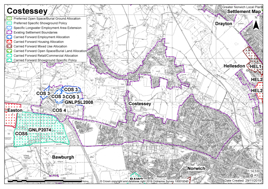
No new allocations are proposed
Notes
There has been, and continues to be, a significant amount of growth in Costessey. In addition, due to their proximity to one another, Costessey and Easton share several key facilities and services and Easton also has a major undeveloped housing commitment and identified uplift, totalling more than 1,000 dwellings. The existing committed growth along with the environmental constraints noted above means that no new allocations are proposed.
Existing allocations to be carried forward
|
POLICY COS 3/ GNLPSL2008 Longwater Employment Area, Costessey (approx. 15.4 ha) is allocated for Employment uses.
The development will be expected to address the following specific matters: Uses
Transport
Constraints
|
Notes
COS 3: The site was allocated in 2015 as part of the current local plan and employment uses in this location remain appropriate. The site is re-allocated with additional land promoted as GNLPSL2008 and with up-to-date policy wording.
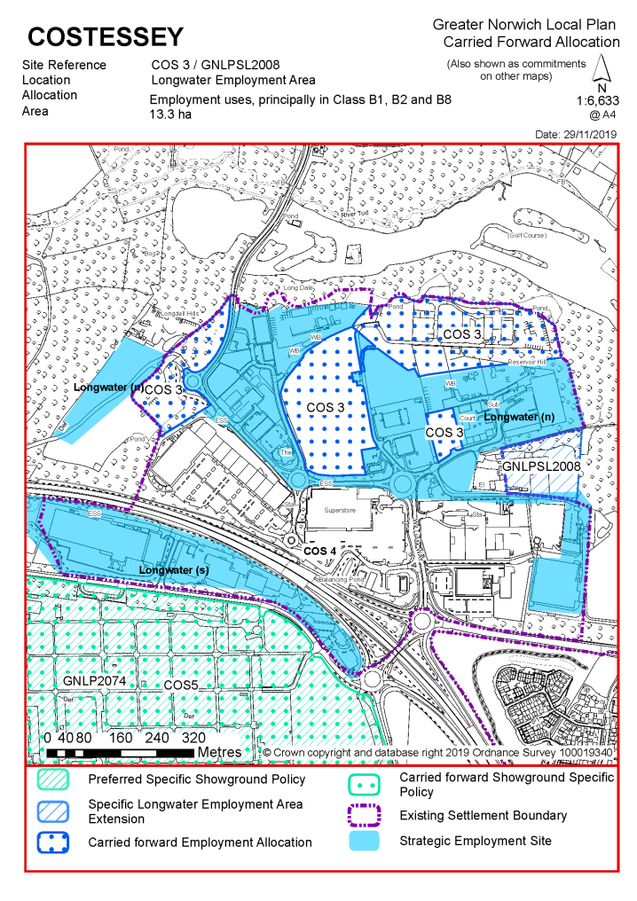
|
POLICY COS 4 Redevelopment of existing uses within the Costessey Longwater Development Boundary, Costessey.
Within the Costessey Longwater Development Boundary proposals for the redevelopment or change of use of existing employment, retail, commercial and leisure uses will demonstrate that retention of the site for the same or similar uses has been fully explored without success. This would involve:
Where this has been demonstrated, sites within Costessey, Longwater Development Boundary, will be considered positively for Class B1, B2 and B8 employment uses or other employment uses ancillary and complementary to the strategic employment function of the area where they are not defined as a Main Town Centre use in the National Planning Policy Framework, specifically further car showrooms and petrol filling stations. |
Notes
COS 4: The development boundary of the Longwater Employment Area was defined in 2015 as part of the previous local plan and seeks to guide the range of uses permitted. Retention of the development boundary and policy to guide the uses permitted is considered justified. Policy COS 4 protects the commercial activities in this location and ensures the range of uses taking place at Longwater are compatible with each other.
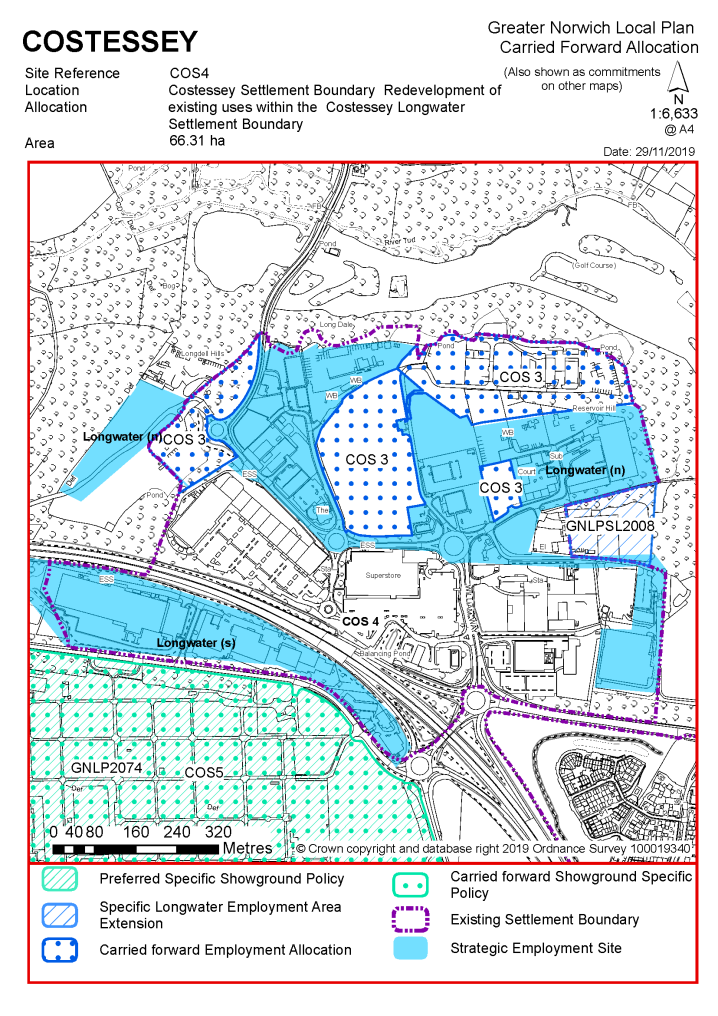
|
POLICY COS 5 / GNLP2074 Royal Norfolk Showground, Costessey
Planning applications for the use of the identified area for leisure, tourism, recreation, arts and exhibition uses will be considered positively provided that:
|
Notes
COS 5 / GNLP2074: This site is preferred for allocation, minus the small area of land to the east of Long Lane. It is proposed to revise the COS5 allocation from the existing South Norfolk Local Plan to remove the family golf centre and site GNLP2074 is preferred on the same boundary as the revised COS5 allocation. The policy wording has also been revised to take account of updated wording suggested by the site promoter.
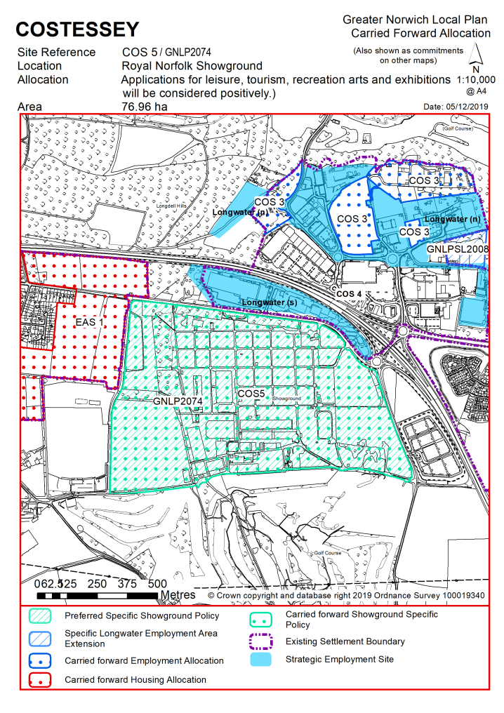
|
Address |
Site Reference |
Area (ha) |
Promoted for |
Reason for not allocating |
|
Costessey |
||||
|
Roundwell Works Site |
GNLP0593 |
1.27 |
Approx. 55 dwellings |
This site is considered to be a reasonable alternative if further housing is needed in the urban area. It is a brownfield site located within the existing settlement limit which has previously been allocated in South Norfolk local plans. Development would be subject to the loss of employment land, tree and access considerations. Vehicular access to Dereham Road may be difficult but alternative access via Millcroft Close could be explored. |
| (4) | ||||
|
Land off Bawburgh Lane and New Road
|
GNLP0581 |
49.65 |
Residential (unspecified number) with associated amenity land, woodland and green area |
This site is considered to be a reasonable alternative if further housing is needed in the urban area. It is included as a contingency site in the draft local plan for up to 1000 dwellings should this prove to be required due to low delivery of allocated housing sites. There are issues regarding access and the site's location in the Norwich Southern Bypass Protection Zone and designated river valley. The site is not currently preferred for allocation as limited evidence has been submitted regarding its deliverability. Availability of third-party land to deliver both proposed accesses has to be confirmed. Access to Long Lane for all traffic would not be appropriate. |
| (3) | ||||
|
North of New Road, east of A47 |
GNLP2043 |
11.70 |
150-200 dwellings |
This site is considered to be a reasonable alternative if further housing is needed in the urban area, but it would need to be developed in conjunction with GNLP0581 to be acceptable. It is included as a contingency site (along with GNLP0581) in the draft local plan for up to 1000 dwellings should this prove to be required due to low delivery of allocated housing sites. The site is not preferred for allocation for the same reasons as GNLP0581 above. |
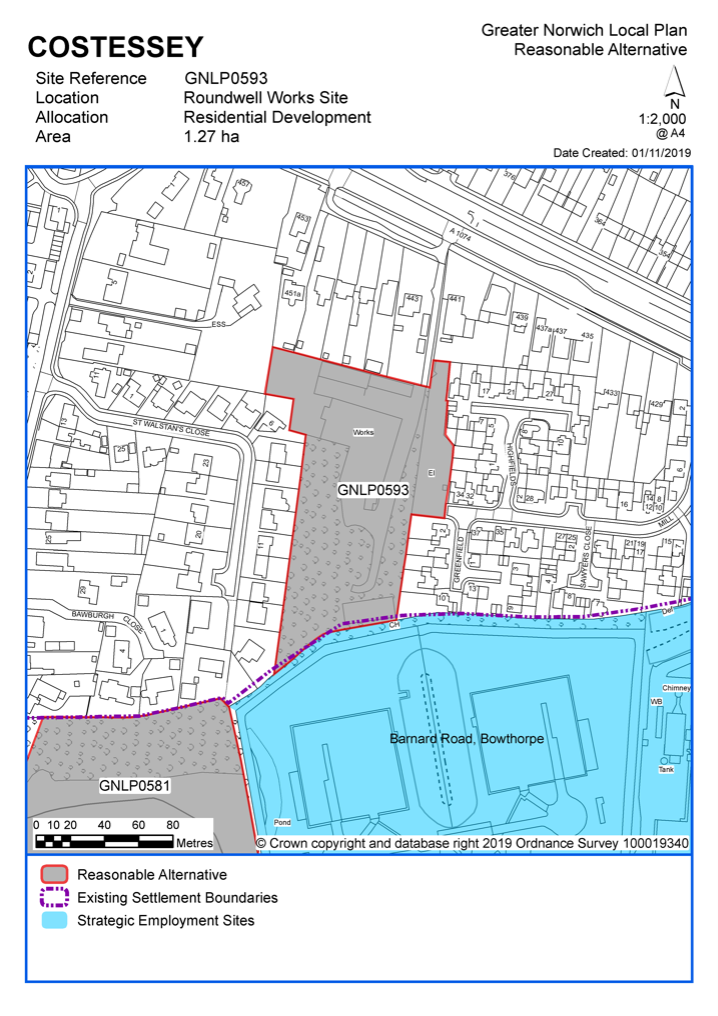
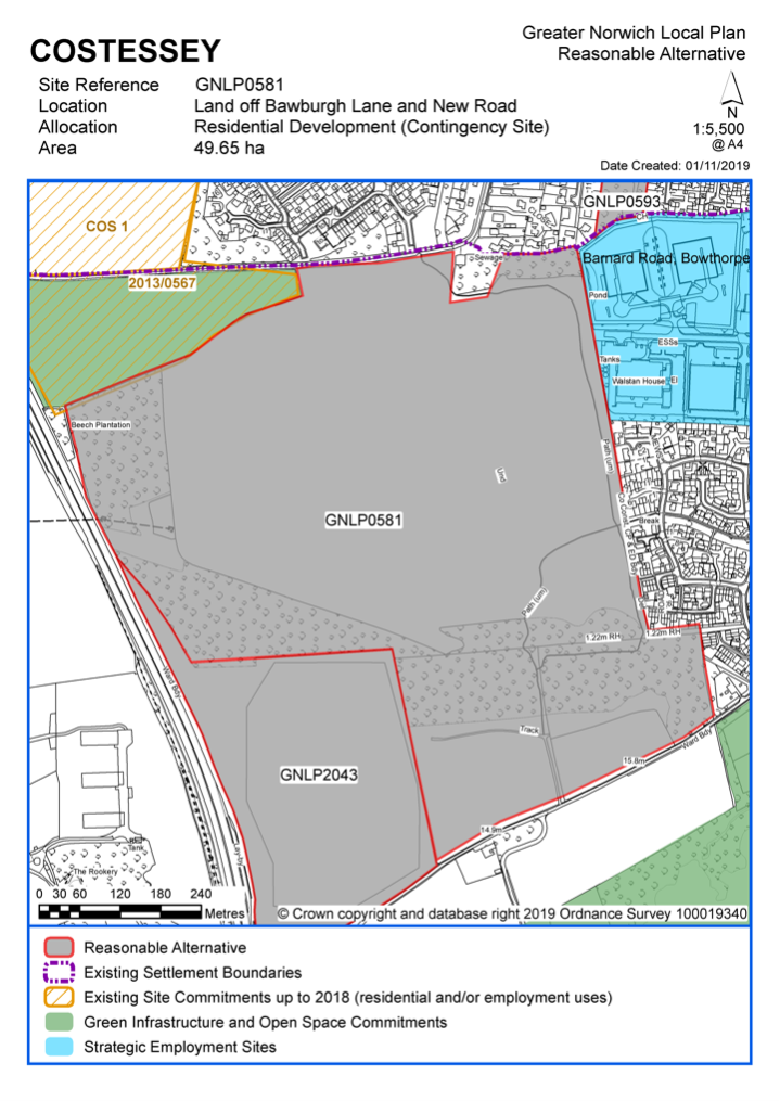
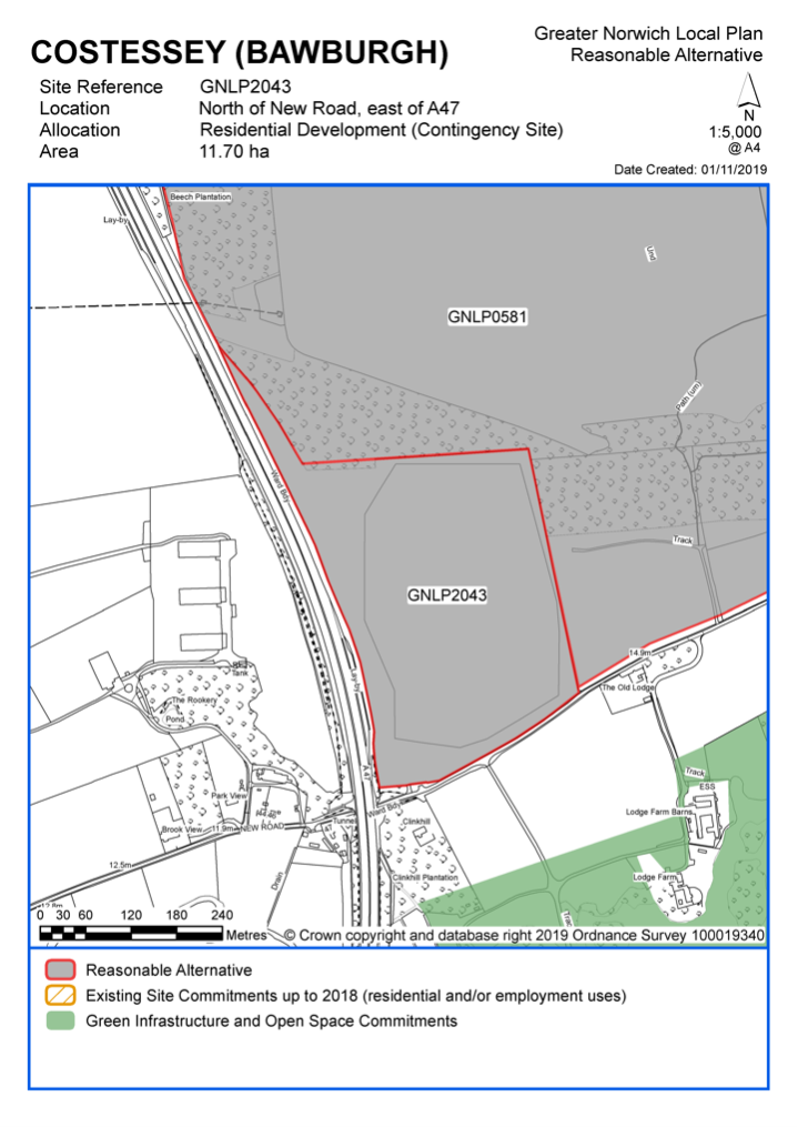
Unreasonable Sites - Residential
|
Address |
Site Reference |
Area (ha) |
Promoted for |
Reason considered to be unreasonable |
|
Costessey |
||||
|
Land to the north east of Town House Road |
GNLP0039 |
11.39 |
Residential (unspecified number) |
This site is not considered to be suitable for allocation as it is disconnected from the existing settlement limit and within the designated river valley which raises some landscape concerns. Development here would have a poor relationship to the existing settlement pattern and it is likely that the purchase of third-party land would be required to facilitate a suitable access. |
|
|
||||
|
Land south of Cleves Way/ East of Longwater Lane |
GNLP0206 |
17.82 |
Residential (unspecified number) |
There is a significant band to the south of this site which is at risk of flooding (zone 3b). To avoid this area the site would need to be developed with GNLP0284 for access and to form a cohesive development. It is therefore not considered to be suitable for allocation. |
|
|
||||
|
Land north of Farmland Road |
GNLP0238 |
7.09 |
Approx. 84 dwellings and public open space |
This site is not considered to be suitable for allocation as a recent appeal was dismissed due to adverse impact on the designated river valley and poor connectivity. |
|
|
||||
|
12 Longwater Lane |
GNLP0243 |
2.75 |
Residential (unspecified number) |
This site is not considered to be suitable for allocation due to access constraints and form and character concerns. The majority of the site is in the designated river valley with a number of established trees. The access point is between an existing dwelling and a belt of trees which have preservation orders on them which could be problematic for achieving adequate vehicular access. |
|
|
||||
|
Costessey Landfill Site and adjoining land, Dereham Road |
GNLP0266 |
46.62 |
Mixed use |
Although the western end of the site (near to the existing employment/industrial uses) could have potential for commercial use the remainder is not favoured for housing due to the possible contamination issues of building on a landfill site, indeed Norfolk County Council Minerals and Waste have objected to development of the site. In addition, the site would create an isolated area of residential development with possible amenity issues from the existing commercial development nearby. Land could be required for an all traffic link between the A1074 Dereham Road and Ernest Gage Avenue. |
|
|
||||
| (1) | ||||
|
Townhouse Road |
GNLP0284R |
8.98 |
Residential (unspecified number). 3 masterplan options of different sizes put forward |
This site is not considered suitable for allocation due to potential adverse impact on the character of the designated river valley. Three different masterplans have been submitted varying in scale. A small road frontage scheme may be more acceptable, but this would still have landscape impact as well as a heritage impact on the adjacent Grade II Listed Church. |
|
|
||||
|
Land off Ringland Lane |
GNLP0468 |
4.43 |
Approx. 50 dwellings with open space |
This site is not considered to be suitable for allocation as it is located some distance from the existing settlement limit in the designated river valley. There is a central band of surface water flood risk which would significantly affect the developable area. |
|
|
||||
|
Land off Gunton Lane |
GNLP0489 |
2.57 |
Residential (unspecified number) |
Much of this site is affected by flood zones 2 and 3 and surface water flood risk. Anglian Water infrastructure in the vicinity of the site could be a further constraint and for these reasons the site is not considered to be suitable for allocation. |
|
|
||||
|
Rear of 23 Longwater Lane |
GNLP2004 |
0.60 |
4-10 dwellings |
This is a difficult shaped site unlikely to be able to accommodate enough dwellings to enable an allocation. Established trees, flood zones 2 and 3 and surface water flood risk would significantly affect the developable area. |
|
|
||||
| (1) | ||||
|
North of Gunton Lane |
GNLP2138 |
2.60 |
Residential (unspecified number) |
This site is not considered to be suitable for allocation as it is covered by flood zones 2 and 3 and surface water flood risk which would significantly affect the developable area. In addition, the site is within the designated river valley and wholly within a County Wildlife Site. |
|
|
||||
|
10 Longwater Lane |
GNLP2156 |
1.90 |
Residential (unspecified number) |
This site is not favoured for allocation. It is located a short distance from the existing settlement limit within the designated river valley. Vehicular access to the site would-be difficult as the whole frontage is an area of established trees with preservation orders on them. |
|
|
||||
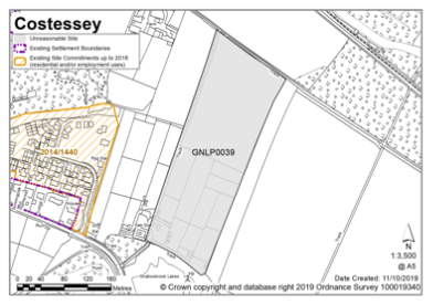
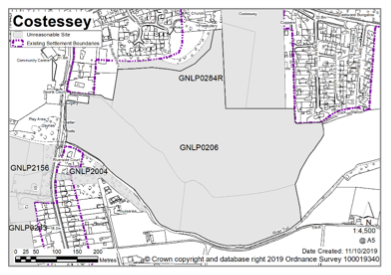
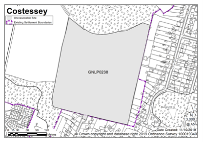
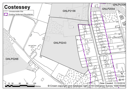
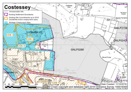
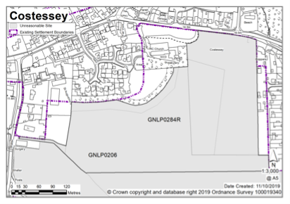
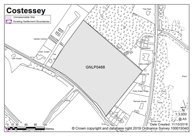

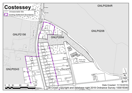
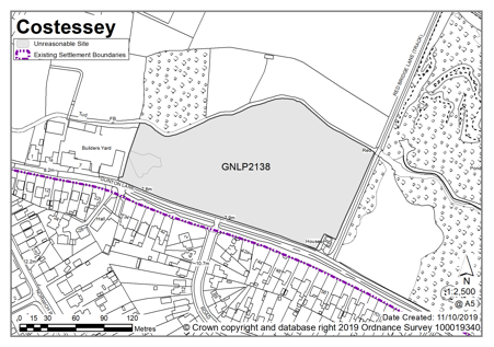
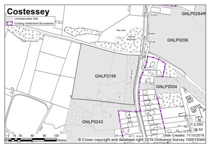
Unreasonable Sites - Non-residential
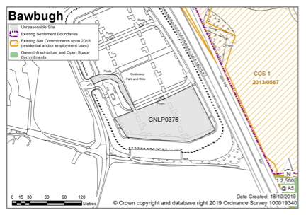
CRINGLEFORD (Including employment allocation at Keswick)
Cringleford is classified as an urban fringe parish. There are good links to the University of East Anglia, Norfolk & Norwich University Hospital, and Norwich Research Park. Major development is underway in the parish, with significant commitments as yet unbuilt. Amongst the facilities in the parish are a doctors surgery, primary school, shops and community buildings. An additional primary school is planned as part of the currently committed development. The A11/Newmarket Road runs through the parish, joining at Thickthorn with the A47, to the west. To the east, the parish's boundary is formed by the River Yare valley. There are some areas of fluvial and surface water flooding risk and the parish also contains a few County Wildlife Sites. Cringleford has had a Neighbourhood Plan in place since February 2014.
There are no new sites identified as preferred options in Cringleford. There is one carried forward allocation (for 1300 homes, with an uplift of 360 additional homes) and a total of 61 additional dwellings with planning permission. This gives a total deliverable housing commitment for Cringleford of 1,721 homes between 2018 – 2038.
All new and carried forward allocations are expected to address standard requirements associated with development. These vary from place to place, but are likely to include mitigations for flood risk (as well as SUDs), highways improvements, safeguarding of minerals resources, land remediation, measures to protect the environment, biodiversity, and landscape intrusion.
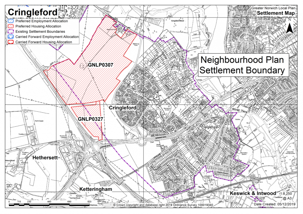
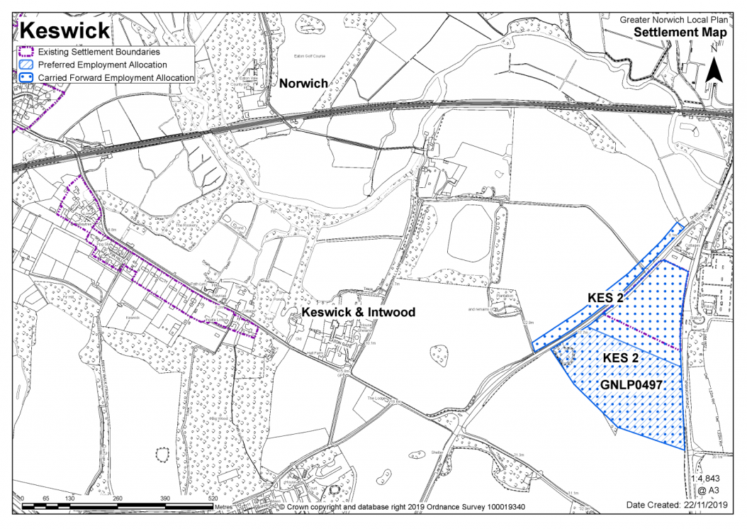
Existing Neighbourhood Plan allocation carried forward
|
Policy Cringleford Neighbourhood Plan HOU1 (GNLP0307/GNLP0327) Land north and south of the A11 (approx. 52.56 ha) is allocated for residential development and associated infrastructure. This will accommodate approximately 1,660 homes. The development will be expected to address the following specific matters:
|
Notes
GNLP0307/GNLP0327: The Cringleford Neighbourhood Plan identified an area for approximately 1,200 new homes for which permissions are in place (outline application references 2013/1494 and 2013/1793) for up to 1,300. These permissions do not occupy the whole of the housing site allocation in the Neighbourhood Plan. The remaining area of land identified in the Neighbourhood Plan as suitable for development is located between the Norwich southern bypass Landscape Protection Zone (set out in the Neighbourhood Plan) and the edge of the permitted schemes. giving potential for further development beyond 2026. The uplift in housing on land allocated for development is estimated as an extra 360 dwellings on top of the 1,300 dwellings already permitted. In addition, both outline permissions make provision for a primary school site, but only that within outline 2013/1793 will be required. The primary school site within outline permission 2013/1793 is approximately 2 hectares, the identified housing uplift is likely to require a larger school site, to be accommodated on land adjoining the already identified site.
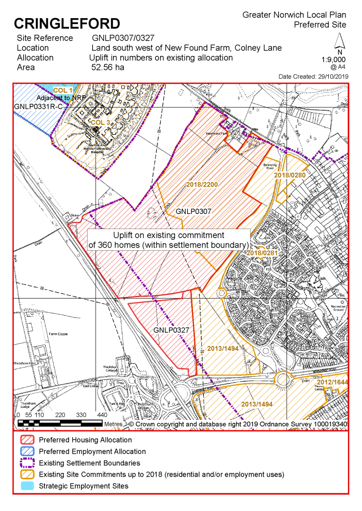
Existing allocation to be carried forward
|
POLICY KES 2 (including GNLP0497) Land west of Ipswich Road, Keswick (approx. 12 ha) is allocated for employment uses.
The development will be expected to address the following specific matters:
|
Notes
KES 2/GNLP0497: This site is preferred for allocation recognising that employment allocation KES2 from the South Norfolk Local Plan now has planning consent (reference 2017/2794) on a larger boundary that incorporates site GNLP0497. The carried forward allocation will be redrawn accordingly.
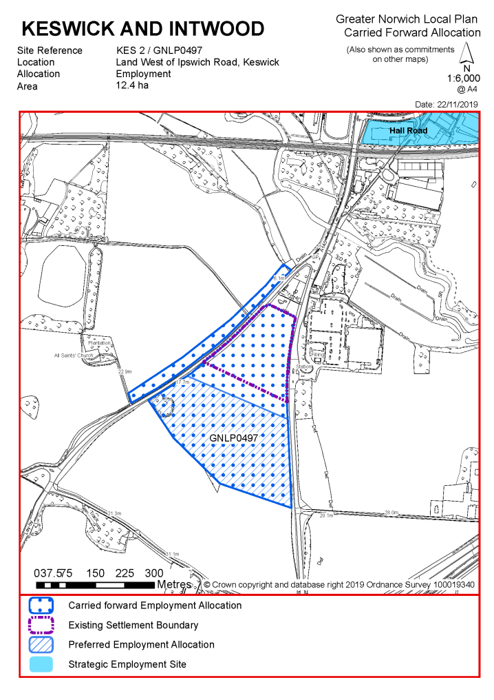
|
Address |
Site Reference |
Area (ha) |
Promoted for |
Reason for not allocating |
|
Cringleford |
||||
|
NO REASONABLE ALTERNATIVE SITES
|
||||
Unreasonable Sites - Residential
|
Address |
Site Reference |
Area (ha) |
Promoted for |
Reason considered to be unreasonable |
|
Cringleford |
||||
| (1) | ||||
|
Land off Gurney Lane |
GNLP0461 |
2.79 |
Approx. 40 dwellings with open space for amenity purposes |
This site is not considered to be suitable for allocation, as it is not feasible to achieve an acceptable visibility splay southward along Colney Lane from Gurney Lane. There are also possible landscape impacts on the Yare Valley to consider. |
|
|
||||
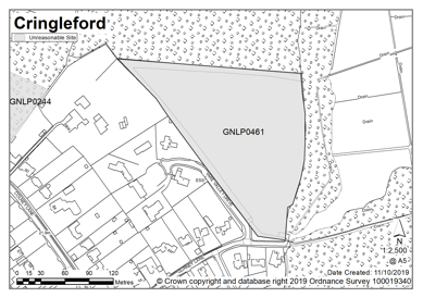
Unreasonable Sites - Non-Residential
|
Address |
Site Reference |
Area (Ha) |
Proposal |
Reason considered to be unreasonable
|
|
Cringleford (including employment land at Keswick) |
||||
| (1) | ||||
|
A140/Mulbarton Road, Keswick |
GNLP3047 |
16.10 |
Employment |
This site is not considered to be suitable for allocation as evidence suggests that currently committed land is more than sufficient in quantity and quality to meet the employment growth needs in Greater Norwich. There is therefore no need to allocate any additional large-scale employment sites in the new local plan. This area is outside the planning application boundary for the extended KES2 allocation in the South Norfolk Local Plan. |
|
|
||||
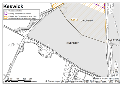
Drayton is classified as an urban fringe parish. There are good public transport links to Norwich along the Fakenham Road (A1067). Transport connectivity has also been recently improved by the opening of the Broadland Northway (A1270). There is a good range of local services mainly concentrated in the village centre, near the junctions of Drayton High Road with School Road and Costessey Lane. Drayton is located close to the River Wensum, itself designated as a Special Area of Conservation (SAC), and there are Sites of Special Scientific Interest as well. Away from the River Wensum, two county wildlife sites, Canham's Hill and Drayton Woods, provide a landscape gap between Drayton and Hellesdon to the east and between Drayton and Horsford to the north. In recent decades Drayton has seen new development at Thorpe Marriott.
Drayton Neighbourhood Plan was 'made' in July 2016 and covers the period to 2026. The vision for the Neighbourhood Plan is based on their desire to maintain the quality of life in their Parish by preserving the balance between the built and green environment, improving negative elements of the built environment and infrastructure whilst developing and strengthening opportunities for the people of the parish, encouraging increased prosperity, and building up the facilities available to residents, and those that work there.
There are no sites identified as preferred options in Drayton. There is one carried forward allocation for 250 homes and a total of 68 additional dwellings with planning permission on small sites. This gives a total deliverable housing commitment for Drayton of 318 homes between 2018 – 2038.
All new and carried forward allocations are expected to address standard requirements associated with development. These vary from place to place but are likely to include mitigations for flood risk (as well as SUDs), highways improvements, safeguarding of minerals resources, land remediation, measures to protect the environment, biodiversity, and landscape intrusion.
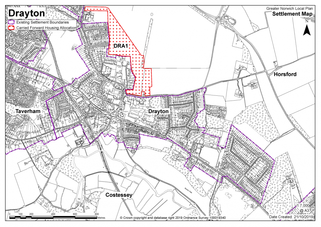
Notes
High amounts of existing commitments and environmental/infrastructure constraints limit the potential for additional housing.
Existing allocation to be carried forward
|
POLICY DRA1 Land east of Cator Road and north of Hall Lane, Drayton (Approx. 12.5 ha) is allocated for residential development, allotments and open space. This will accommodate approximately 250 homes. The development will be expected to address the following specific matters:
|
Notes
DRA1: The site was allocated in 2016 as part of the previous local plan but has not yet been developed. The principle of development on the site has already been accepted and it is expected that development will take place within the time-period of the new local plan up to 2038. The site is likely to accommodate at least 250 homes reflecting planning permission 20161066 resolution to grant outline approval subject to the satisfactory completion of a Section 106 Agreement. More may be accommodated, subject to an acceptable design and layout etc. being achieved. DRA1 will be incorporated into the settlement limit when it is completed.
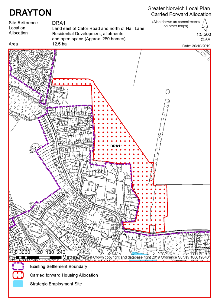
|
Address |
Site Reference |
Area (ha) |
Promoted for |
Reason for not allocating |
|
Drayton |
||||
| (1) | ||||
|
NO REASONABLE ALTERNATIVE SITES
|
||||
Unreasonable Sites - Residential
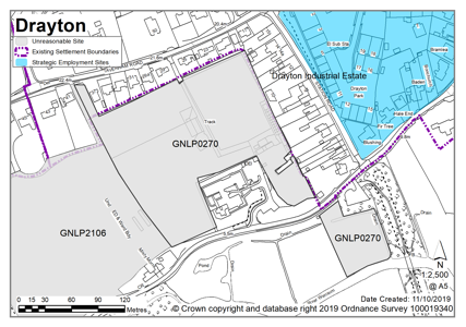
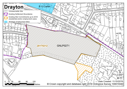
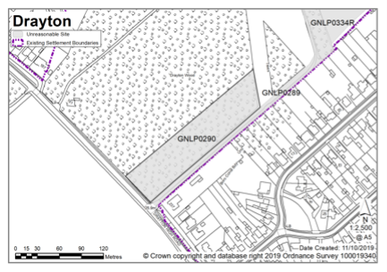
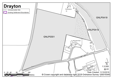
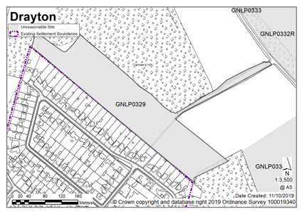
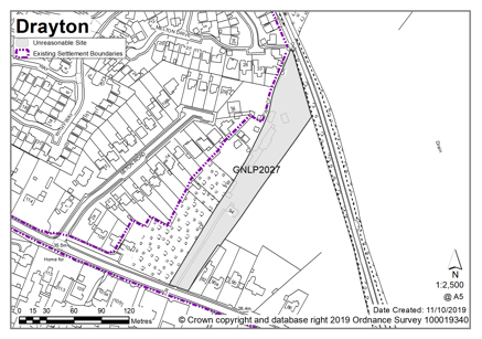
Unreasonable Sites – Non residential
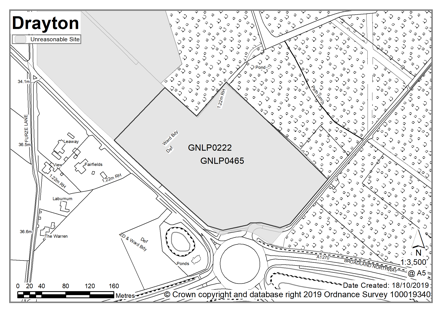
Easton is identified as an urban fringe settlement. There is a major growth allocation, with outline planning permission for development of 893 homes on land to the east, south and west of the village. Proposals include an extended primary school, a new village hall, a small retail store and areas of public open space. Around Easton, defining features are the Royal Norfolk Showground to the east of the village (within Costessey parish), the A47 Southern Bypass that runs to the north of the main built up area, and Easton College to the south. The high-quality sports facilities at the College are conveniently accessible for Easton residents, as are the employment opportunities, retail and leisure facilities at Longwater.
Easton Neighbourhood Plan was made in December 2017 and covers the period to 2042. It contains a series of policies that look to shape development within the neighbourhood area. There are policies within the plan that will be of relevance to development and any applications that are submitted for development within the parish should have due regard to those policies.
Honingham is a small village immediately south of the A47 Southern Bypass in the Broadland district. The River Tud flows through the Village and consequently some areas are at fluvial and surface water flood risk. The majority of Honingham parish is rural, but the designation of a Food Enterprise Zone (FEZ) for businesses focused upon food processing and production should be noted. Currently 19 hectares of the FEZ, with a net developable area of approximately 16.5 hectares, benefits from Local Development Order (LDO) status promoting commercial development land on this site in units of varying scale.
There is one carried forward allocation at Easton totalling 1,044 homes. In addition, there is one site identified as a preferred option in Honingham providing for 12 new homes and one additional dwelling with planning permission. This gives a total deliverable housing commitment for Easton and Honingham together of 1,057 homes between 2018 – 2038.
All new and carried forward allocations are expected to address standard requirements associated with development. These vary from place to place, but are likely to include mitigations for flood risk (as well as SUDs), highways improvements, safeguarding of minerals resources, land remediation, measures to protect the environment, biodiversity, and landscape intrusion.
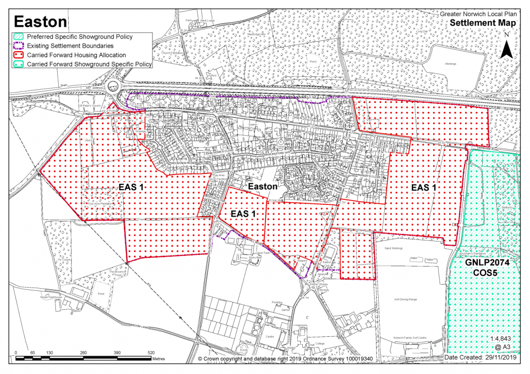
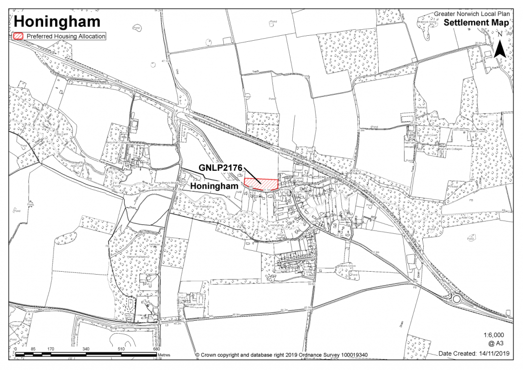
|
POLICY GNLP2176 Land North of Dereham Road, Honingham (approx. 0.76 ha) is allocated for residential development. This will accommodate at least 12 homes, 33% of which will be affordable. More homes may be accommodated, subject to an acceptable design and layout, as well as infrastructure constraints. The development will be expected to address the following specific matters:
|
Notes
GNLP2176: This site is preferred for allocation based on the additional work done on school bus routes. The site as promoted is too large, so it is proposed to allocate a smaller area for frontage development only which would make a natural infill development. Allocation is subject to provision of an adequate carriageway and footway for the full extent of the frontage.
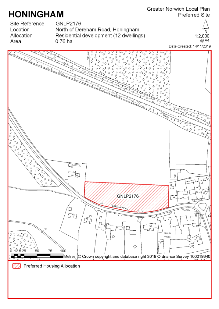
Existing allocation to be carried forward
|
POLICY EAS 1 Land south and east of Easton (approx. 52.6 ha) is allocated for residential development and associated infrastructure. This will accommodate approximately 1,044 homes.
The development will be expected to address the following specific matters: Master Plan A comprehensive masterplan which will need to cover the provision of social and green infrastructure and highways improvements, taking into account the other requirements of this policy, and address:
Enhanced Facilities
Heritage Assets
Landscaping and Green Infrastructure
Transport Highways and transport improvements agreed with Norfolk County Council and, where appropriate, the Highways Agency, to include;
Site conditions and constraints
|
Notes EAS 1: The site was allocated in 2015 as part of the previous local plan but has not yet been developed. The principle of development on the site has already been accepted and it is expected that development will take place within the time-period of the new local plan up to 2038. The site has outline planning permission for 890 units, but this does not cover the whole of the allocation. A separate application for 64 dwellings is under consideration at the time of preparing this draft plan on some of the remaining allocated land, north of Dereham Road. It is considered that there is capacity for an additional 90 dwellings on the last parcel of allocated land, to the east of Easton Gymnastics Club. The site is therefore re-allocated for residential development and has been considered in the calculation of the housing requirement for a total of 1,044 units. Via the development management process, it has become apparent that EAS 1 could be uplifted by a further 90 dwellings from the original estimate of approximately 900 dwellings. Subject to acceptable mitigation measures, an uplift of EAS 1 is the preferred approach.
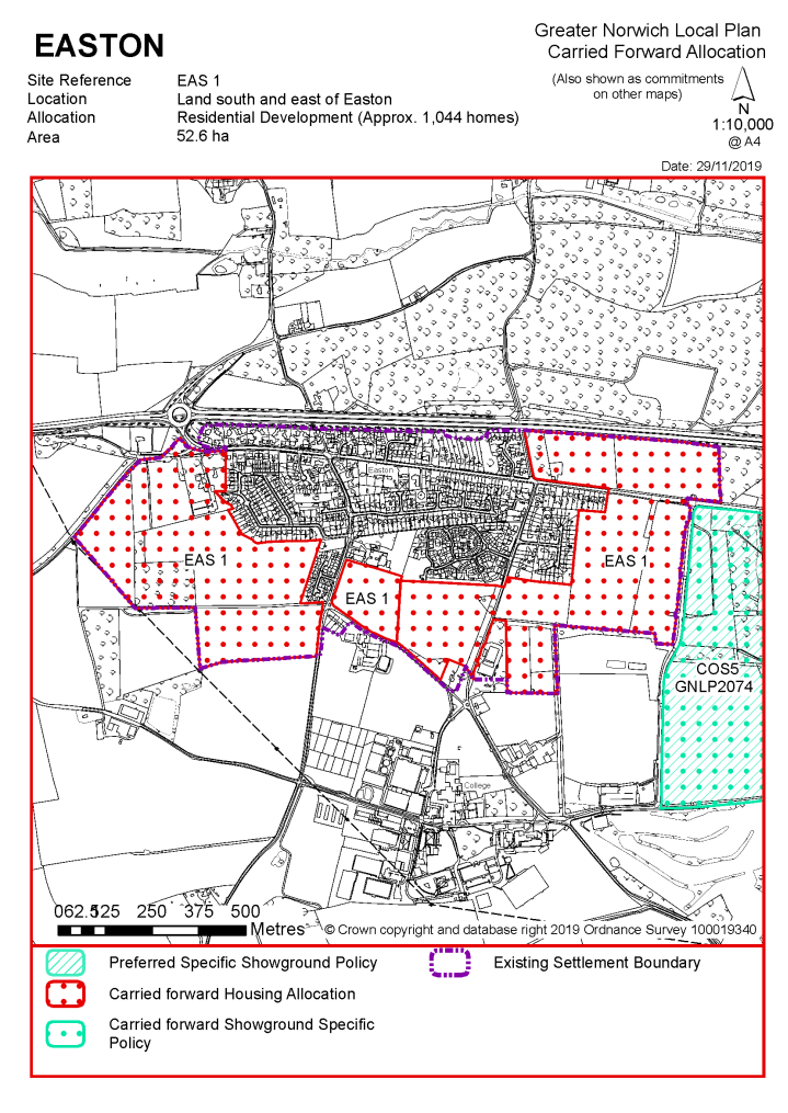
|
Address |
Site Reference |
Area (ha) |
Promoted for |
Reason for not allocating |
|
Easton and Honingham |
||||
| (28) | ||||
|
Honingham Thorpe |
GNLP0415 A-G |
457.14 |
Strategic mixed-use development consisting of residential development, employment, country park and nature reserve |
This combination of sites is considered to be a reasonable alternative for consideration as a new settlement through a future review of the plan. The site is not preferred for allocation as it is not proposed to include a new settlement in the Greater Norwich Local Plan at the current time. |
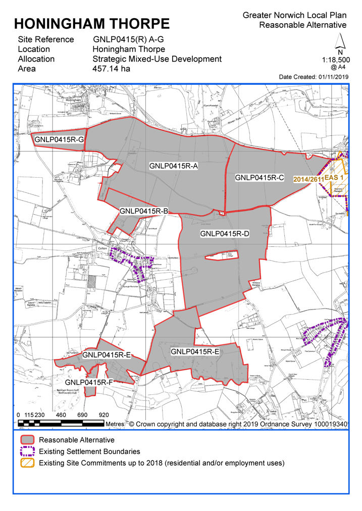
Unreasonable Sites - Residential
|
Address |
Site Reference |
Area (ha) |
Promoted for |
Reason considered to be unreasonable |
|
Easton and Honingham |
||||
| (3) | ||||
|
Land off A47, Easton |
GNLP0456 |
9.12 |
Approx. 25 dwellings |
This site is not considered to be appropriate for allocation as it is located on the opposite side of the A47 to the main part of Easton village with no safe route to the primary school. The site also includes a gravel pit of geological interest. |
|
|
||||
| (4) | ||||
|
Land at Fellowes Road, Honingham |
GNLP0411 |
0.72 |
Approx. 13 dwellings |
This site is over 4km to primary school in Easton with no safe walking route therefore it is not considered to be suitable for allocation. This site was re-examined through work looking at County Council bus routes to school but was dismissed as it was considered that vehicular access would be difficult as the proposed access point at Fellowes Road is extremely narrow and Mill Lane is also sub-standard. |
|
|
||||
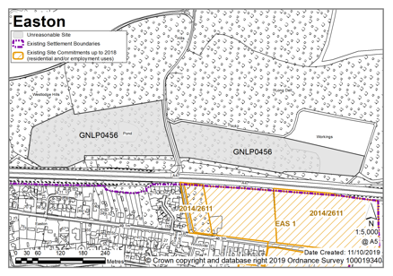
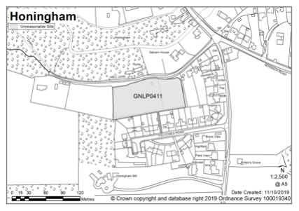
Hellesdon is as an urban fringe parish. Away from the River Wensum Valley much of the parish is already built up. There is a good range of local facilities and public transport to Norwich City Centre. Amongst the existing planning permissions is redevelopment of the Royal Norwich Golf Club for up to 1,000 homes. There are long-term proposals to redevelop parts of the Hellesdon Hospital site as well. To the west of the parish are the environmental designations associated to the River Wensum, which is a Special Area of Conservation, as well as Sites of Special Scientific Interest. Between the built edges of Hellesdon and Drayton, Canham's Hill and Drayton Wood (County Wildlife Sites) form important landscape features. Constraints to the north-east of the parish include the designated safety zone and associated noise implications relating to Norwich International Airport. Notably, much of the greenfield land north of Hellesdon is within the parish boundary of Horsford.
Hellesdon Neighbourhood Plan was 'made' in December 2017 and covers the period to 2026. The vision for the Hellesdon Neighbourhood Plan is to be a green, peaceful and friendly suburb for people of all ages with a good range of community facilities; one step from a vibrant city and one step from the Norfolk countryside.
There are no sites identified as preferred options in Hellesdon. There are two carried forward allocations providing a total of 1,300 homes and a total of 25 additional dwellings with planning permission on smaller sites. This gives a total deliverable housing commitment for Hellesdon of 1,325 homes between 2018 – 2038.
All new and carried forward allocations are expected to address standard requirements associated with development. These vary from place to place, but are likely to include mitigations for flood risk (as well as SUDs), highways improvements, safeguarding of minerals resources, land remediation, measures to protect the environment, biodiversity, and landscape intrusion.
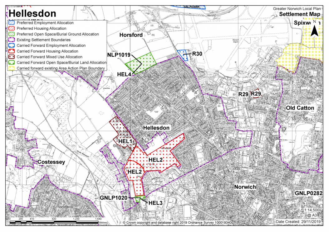
Notes
Much of the parish is already built up and there is a large existing development commitment.
Existing allocations to be carried forward
|
POLICY HEL1 Land at Hospital Grounds, southwest of Drayton Road, Hellesdon (approx. 14.7 ha) is allocated for residential and employment uses. The site will accommodate approximately 300 homes, and B1 employment uses.
More homes may be accommodated, subject to an acceptable design and layout, as well as infrastructure constraints.
The development will be expected to address the following specific matters:
|
Notes
HEL1: The site was allocated in 2016 as part of the previous local plan but has not yet been developed. The principle of development on the site has already been accepted and it is expected that development will take place within the time-period of the new local plan up to 2038. The site is re-allocated for residential development and has been considered in the calculation of the housing requirement. HEL1 will also be incorporated into the settlement limit.
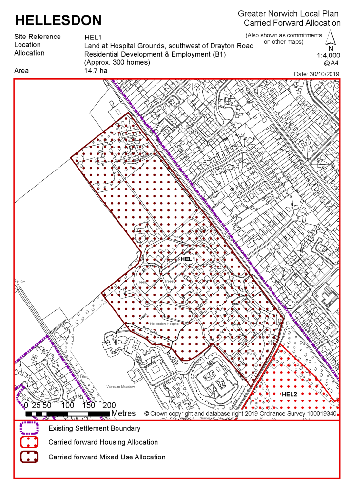
|
POLICY HEL2 - Land at the Royal Norwich Golf Club, either side of Drayton High Road, Hellesdon (approx. 48.1 ha) is allocated for residential and open space uses. This will accommodate approximately 1,000 homes.
More homes may be accommodated, subject to an acceptable design and layout, as well as infrastructure constraints.
The development will be expected to address the following specific matters:
|
Notes
HEL2: The site was allocated in 2016 as part of the previous local plan but has not yet been fully developed. It is expected that the complete development will take place within the time-period of the new local plan up to 2038. The site is re-allocated for residential development and has been considered in the calculation of the housing requirement. HEL2 will also be incorporated into the settlement limit.
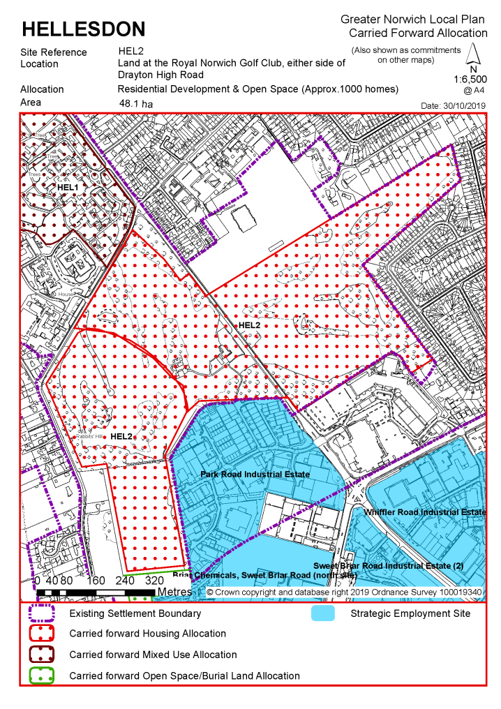
|
POLICY HEL3 / GNLP1020 Land adjacent to existing burial ground – north east of St Marys Church, Hellesdon (approx. 1.3 ha) is allocated for an extension to the existing burial ground.
The development will be expected to address the following specific matters:
|
Notes
HEL3: The site was allocated in the previous local plan and it is intended to carry this allocation forward, recognising a need for more burial land in the future. Under the proposal GNLP1020 the site is again promoted for extending the existing burial ground. However, it is noted that the land is also promoted as part of a larger scheme to extend Hellesdon Industrial Park, as well as provide open space, burial grounds, and a car park for the church (GNLP2142); but, this has not been taken forward in this plan.
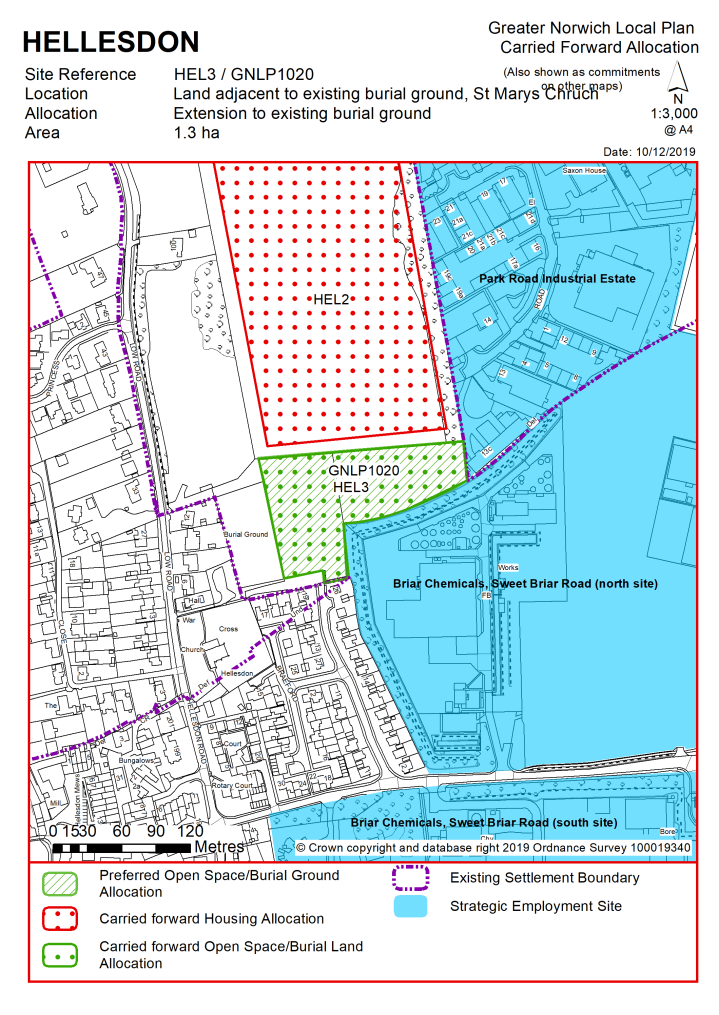
|
POLICY HEL4 / GNLP1019 Land northeast of Reepham Road, Hellesdon (approx. 11.9 ha) is allocated for recreational open space.
The development will be expected to address the following specific matters:
|
Notes
HEL4: The site was allocated in the previous local plan and it is intended to carry this allocation forward, recognising the public benefit in providing informal open space. Under the proposal GNLP1019 the site is again promoted for open space. However, it is noted that the land is also promoted as part of a larger proposal for residential-led development (GNLP0332R), but this has not been taken forward in this plan.
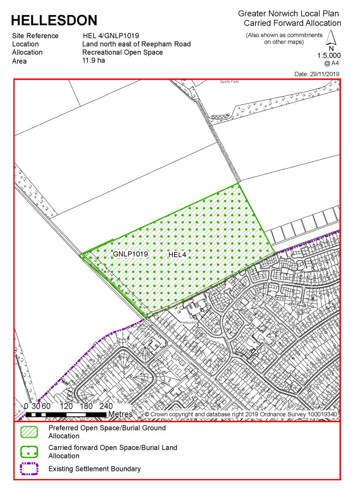
|
Address |
Site Reference |
Area (ha) |
Promoted for |
Reason for not allocating |
|
Hellesdon |
||||
| (45) | ||||
|
Rear of Heath Crescent |
GNLP2173 |
2.11 |
35-50 dwellings |
This site is considered to be a reasonable alternative if additional housing is needed in the urban area. It is well located within the built-up area and highways would support residential development subject to vehicular access via Prince Andrews Road with pedestrian, cyclist and emergency access only via Heath Crescent. However, there is an objection from Sport England which would need careful consideration as would the Parish Council/ Neighbourhood Plan ambition to secure the site for community uses. Residential development would only be appropriate if recreational space requirements in this part of the parish were met. |
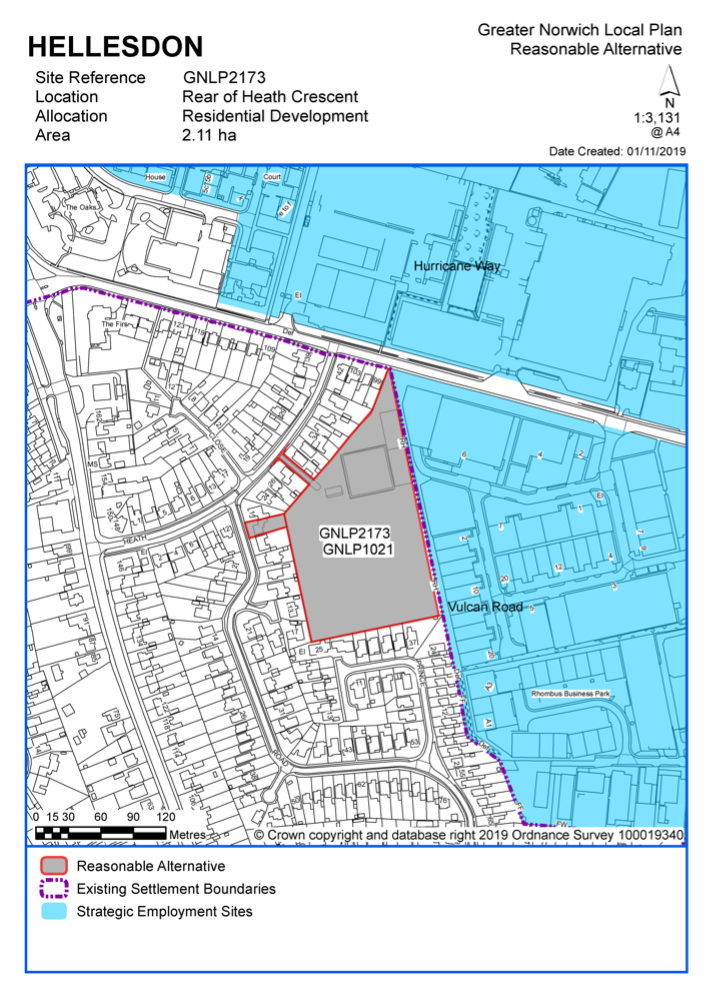
Non-Residential
|
Address |
Site Reference |
Area (Ha) |
Proposal |
Reason for not allocating |
|
Hellesdon |
||||
| (40) | ||||
|
Rear of Heath Crescent, Prince Andrews Road, Hellesdon |
GNLP1021 |
2.07 |
Leisure |
This proposal is considered to be a reasonable alternative for further consideration but is not preferred for allocation at the current time as more information is needed about how the plans put forward by Hellesdon Parish Council sit alongside alternative plans for residential/recreational use put forward by the landowner as site reference GNLP2173, which is also considered to be a reasonable alternative. |
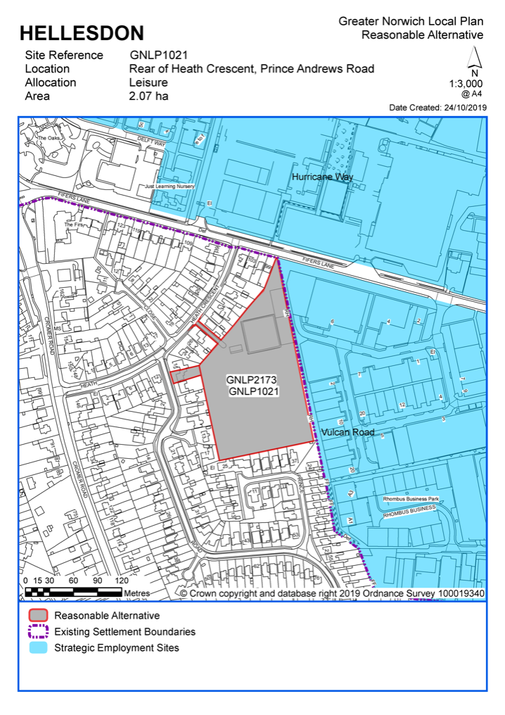
Unreasonable Sites - Residential
|
Address |
Site Reference |
Area (ha) |
Promoted for |
Reason considered to be unreasonable |
|
Hellesdon |
||||
|
NO UNREASONABLE SITES |
||||
Unreasonable Sites – Non Residential
|
Address |
Site Reference |
Area (Ha) |
Proposal |
Reason considered to be unreasonable
|
||||||
|
Hellesdon |
|
|
|
|
||||||
| (1) | ||||||||||
|
West of Hellesdon Park Industrial Estate, Hellesdon |
GNLP2142 |
5.71 |
Extension to industrial estate, burial ground, open space, car park |
This site is not considered to be suitable for allocation as evidence suggests that currently committed land is more than sufficient in quantity and quality to meet the employment growth needs in Greater Norwich. There is therefore no need to allocate any additional large-scale employment sites in the new local plan. |
||||||
|
|
||||||||||
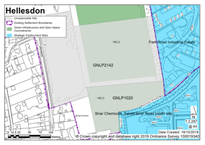
Old Catton is an urban fringe parish and is within an area identified for significant development as part of the Growth Triangle Area Action Plan. Old Catton has had a Neighbourhood Plan in place since July 2016.
There are no sites identified as preferred options in Old Catton. There are no carried forward allocations but a total of 27 additional dwellings with planning permission on small sites. This gives a total deliverable housing commitment for Old Catton of 27 homes between 2018 – 2038.
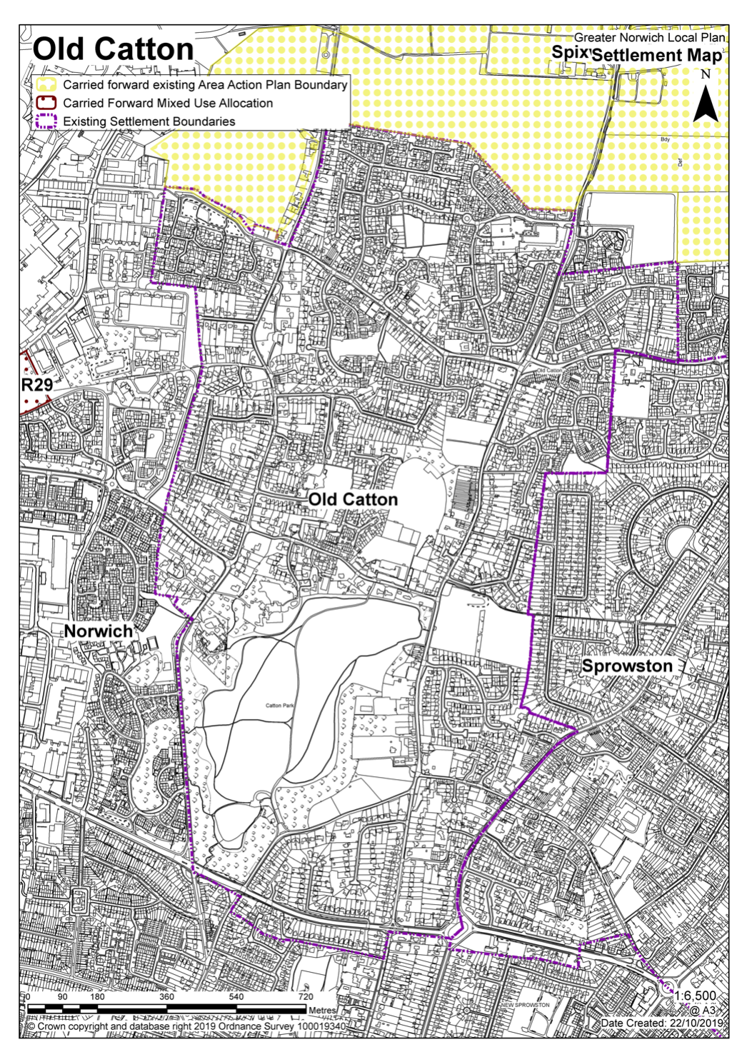
No existing allocations to be carried forward
Notes:
Old Catton is affected by the Growth Triangle Area Action Plan (AAP) which will not be superseded by this plan. The AAP includes sites for development north of the existing Old Catton settlement boundary. No other allocations were made in the previous local plan that affect Old Catton.
|
Address |
Site Reference |
Area (ha) |
Promoted for |
Reason for not allocating |
|
Old Catton |
||||
|
NO REASONABLE ALTERNATIVE SITES
|
||||
|
Address |
Site Reference |
Area (ha) |
Promoted for |
Reason considered to be unreasonable |
|
Old Catton |
||||
|
NO UNREASONABLE SITES |
||||
Rackheath is a predominantly rural parish, but a large part of it is included in the Growth Triangle Area Action Plan proposals. Existing major residential-led developments total approximately 3,500 homes. In form and character, Rackheath is a triangular shaped village consisting of 20th century housing that has mainly developed either side of the Salhouse Road. Current facilities in the village include a primary school, a local shop and post office, a pub and a village hall. There is also local employment opportunity stemming from Rackheath Industrial Estate that is located to the north-west of the village off Green Lane West. Further to the north the A1151 Wroxham Road runs through the parish. Also, a significant recent change, both in landscape setting and transport connectivity, is the opening of the A1270 Broadland Northway. The route of which divides the main part of the village from Rackheath Hall (and its parkland).
Rackheath Neighbourhood Plan was 'made' in July 2017 and covers the period to 2037. The vision for the Neighbourhood Plan is that by 2037 Rackheath will be a small attractive rural town with a village feel, developed in a way that is sensitive to its rural location and heritage. It will have a strong and vibrant resident community and thriving local businesses. There will be an excellent range of services and facilities with good connections within Rackheath and between other settlements. It will be a place where people want to live, work and get involved, now and for future generations.
There are two sites identified as preferred options in Rackheath providing for 215 new homes. There are no carried forward allocations and no additional dwellings with planning permission on small sites. This gives a total deliverable housing commitment for Rackheath of 215 homes between 2018 – 2038.
All new and carried forward allocations are expected to address standard requirements associated with development. These vary from place to place, but are likely to include mitigations for flood risk (as well as SUDs), highways improvements, safeguarding of minerals resources, land remediation, measures to protect the environment, biodiversity, and landscape intrusion.
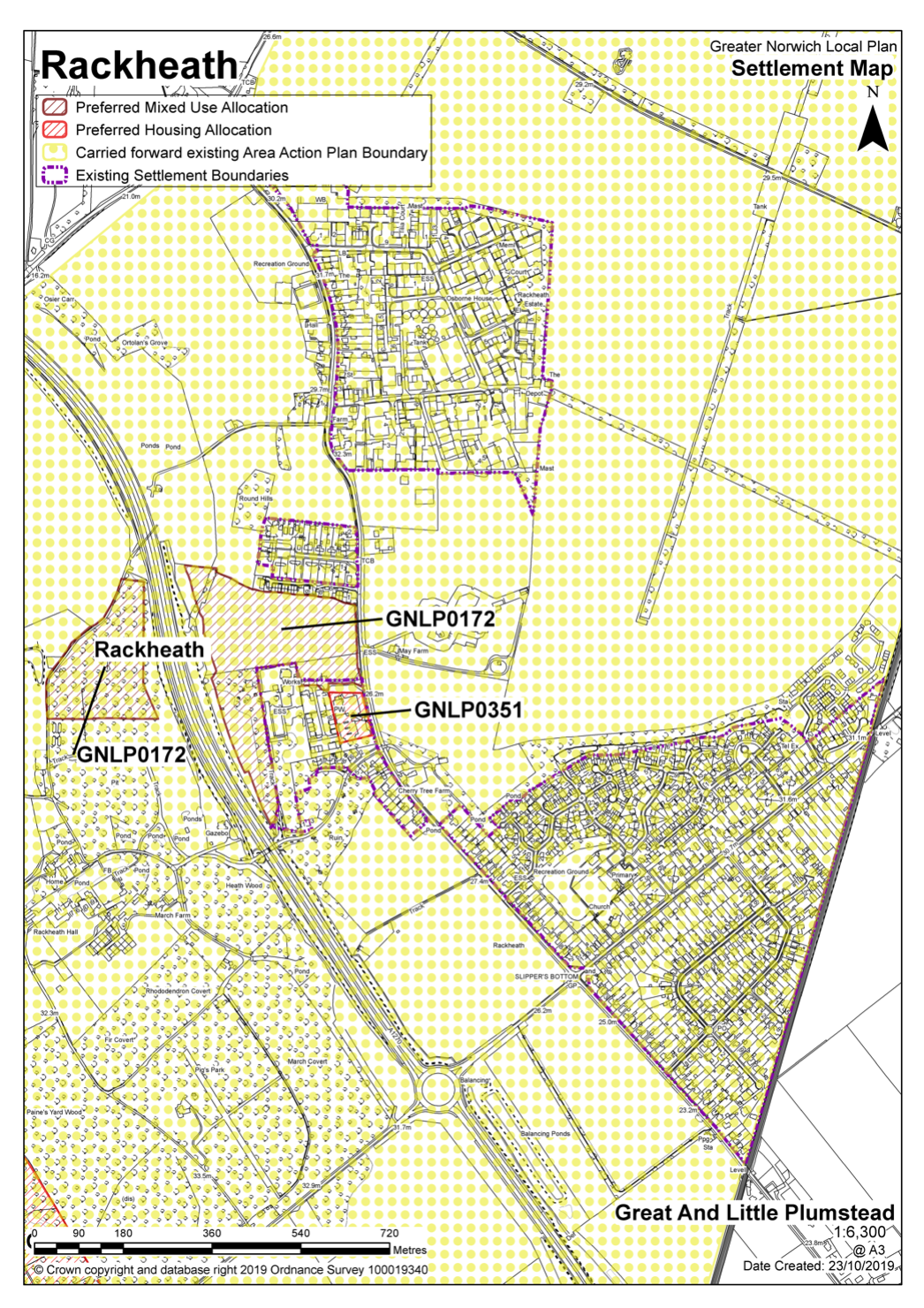
|
POLICY GNLP0172 Land to the west of Green Lane West, Rackheath (Approx. 11.44 ha) is allocated for residential development. This will accommodate approximately 200 homes, 33% of which will be affordable.
More homes may be accommodated, subject to an acceptable design and layout being achieved and any infrastructure constraints addressed. The development will be expected to address the following specific matters:
|
Notes
GNLP0172: This site is promoted as two parcels of land bisected by the Broadland Northway (A1270). It is considered appropriate for allocation as at the date of writing there is an existing committee resolution to approve an application for 205 dwellings on the site (reference 20172208). Residential development should be limited to land to the east of the A1270. Land to the west is only suitable for open space as it is within the landscape buffer for the Broadland Northway and close to the historic gardens of Rackheath Hall, a grade II listed building.
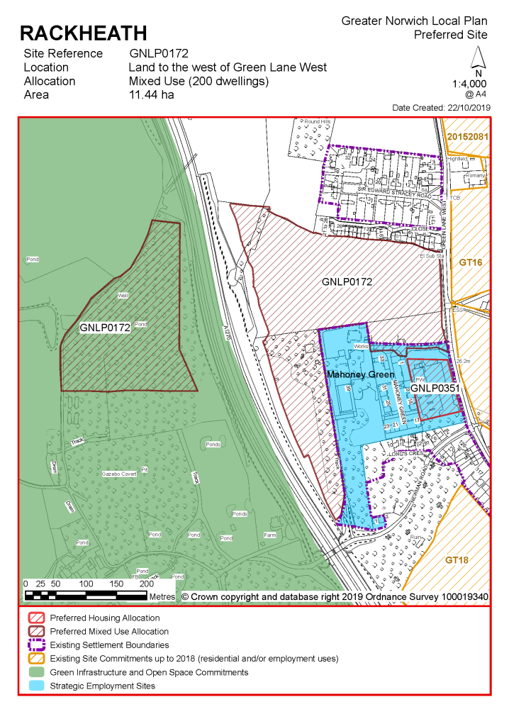
|
POLICY GNLP0351 Land at Heathwood Gospel Hall, Green Lane West, Rackheath (Approx. 0.75 ha) is allocated for residential development. This will accommodate at least 15 homes, 33% of which will be affordable. More homes may be accommodated, subject to an acceptable design and layout being achieved.
The development will be expected to address the following specific matters:
|
Notes
GNLP0351: This is a brownfield site within the existing settlement limit where development is acceptable in principle. Constraints on the site for residential development are relatively few, although some mitigation may be necessary due to the location of industrial buildings to the rear. Subject to footpath connections, and development being limited to the site's frontage the site is preferred for allocation.
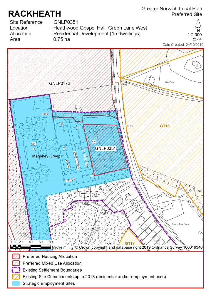
Existing allocations carried forward
Notes
High amounts of existing development commitment remain, as the allocations identified in the Growth Triangle Area Action Plan will not be superseded by the new local plan.
|
Address |
Site Reference |
Area (ha) |
Promoted for |
Reason for not allocating |
|
Rackheath |
||||
|
NO REASONABLE ALTERNATIVE SITES
|
||||
Unreasonable Sites - Residential
|
Address |
Site Reference |
Area (ha) |
Promoted for |
Reason considered to be unreasonable |
|
Rackheath |
||||
| (2) | ||||
|
Land to the east of Salhouse Road |
GNLP0095 |
5.27 |
Up to 8 dwellings off a private drive |
This site is not considered to be suitable for allocation as it is located within land designated as a landscape buffer to the Broadland Northway and is close to Rackheath Hall and its historic gardens with likely landscape character and heritage impacts. Access to facilities is poor, Rackheath Primary school is located on the other side of the Broadland Northway with no safe walking route available. |
|
|
||||
|
Land east of Green Lane West |
GNLP0478 |
44.60 |
Residential development of 142 open market and affordable dwellings with 31.78ha of green infrastructure in the form of a Country Park and recreation ground |
There is potential to consider this site in combination with other sites put forward for development along Green Lane West which is paved and could provide a safe pedestrian route to the school. However, the site is currently an unreasonable alternative, unless the landowner can demonstrate an acceptable access strategy. |
|
|
||||
| (2) | ||||
|
North east of Green Lane West |
GNLP2037 |
1.04 |
10 dwellings |
This site is within the existing settlement limit where development is acceptable in principle provided that it does not result in any significant adverse impact. The site is not considered suitable for allocation as it is unlikely to be able to accommodate the minimum level of allocation and would be better to come forward through the planning application process. |
|
|
||||
| (2) | ||||
|
South of Salhouse Road |
GNLP2092 |
20.84 |
Residential (unspecified number) |
This site is considered to be unsuitable for allocation as it is located within land allocated as a landscape buffer to the Broadland Northway and close to Rackheath Hall and its historic gardens with likely landscape character and heritage impacts. Access to facilities is poor, Rackheath Primary school is located on the other side of the Broadland Northway with no safe walking route available. |
|
|
||||
| (2) | ||||
|
South of Warren Road |
GNLP2166 |
12.94 |
216 dwellings plus GI |
This site is considered to be unsuitable for allocation as it is located within land allocated as a landscape buffer to the Broadland Northway and close to Rackheath Hall and its historic gardens with likely landscape character and heritage impacts. Access to facilities is poor, Rackheath Primary school is located on the other side of the Broadland Northway with no safe walking route available. |
|
|
||||
| (1) | ||||
|
Land east of Back Lane |
GNLP1029 |
0.81 |
Approx. 20 self-build plots |
This site is not considered to be suitable for allocation. The main constraints are over the road junction with Back Lane and the A1151. In addition, the site is 3 km from the primary school with no safe pedestrian route. |
|
|
||||
|
Land south of Dobb's Lane |
GNLP1030 |
2.81 |
84 dwellings |
This site is not considered to be suitable for allocation. The main constraints are over the road junction with Back Lane and the A1151. In addition, the site is 3 km from the primary school with no safe pedestrian route. |
|
|
||||
| (1) | ||||
|
Land to the south of Swash Lane and Muck Lane |
GNLP1060 |
24.73 |
Relocation of Wroxham Football club with mixed use development of residential and commercial |
This site is promoted for mixed use development and relocation of Wroxham Football Club. Relocating the football club would require significant investment, likely to be significantly more than would be achieved from redevelopment of the ground. Given this situation there is not a reasonable likelihood that the proposed residential development at Wroxham (GNLP0041) would take place and so an allocation for the football club at this location is unlikely to be justified at the current time. |
|
|
||||
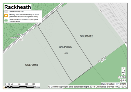
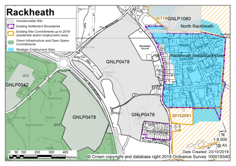
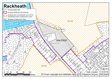
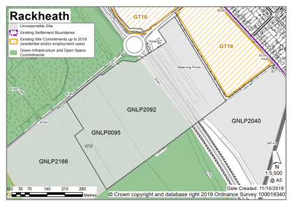
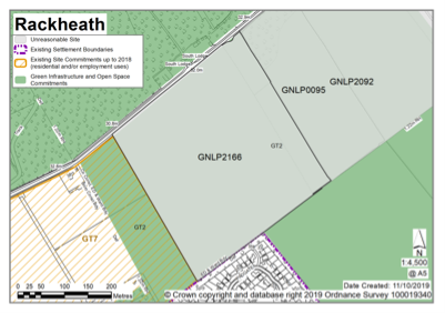
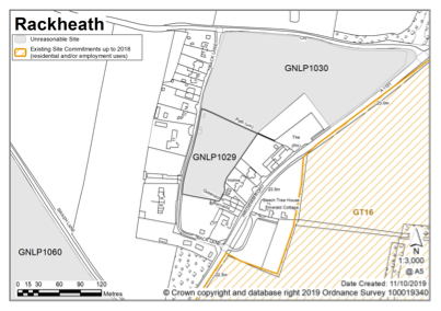
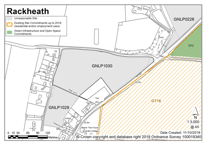
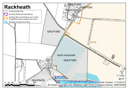
Sprowston is a suburban edge town council area, part of which is within the Growth Triangle Area Action Plan (AAP) boundary, and so it is set for continued development in coming years. The suburban character of the area mainly comprises 20th century semi-detached and detached properties often set in large plots with mature planting. The most significant historic building in Sprowston is the Grade I listed Church of St Mary and St Margaret. In recent decades there has been more estate-scale development but prior to that Sprowston grew along the radial routes out from Norwich. As to services and facilities, a focal point is the retail at Blue Boar, as well as smaller parades of shops, examples being along the Wroxham Road, and at Cannerby Lane. As to landscape features, there are several plantation woodlands, such as Cottage Plantation, Harrison's Plantation, Boar Plantation and the Breck. Sprowston Manor and its grounds, which are used as a hotel and golf course, also form a significant landscape feature. Amongst existing development commitments, several schemes are under construction in the vicinity of White House Farm, to the east of Blue Boar Lane. There is also the Beeston Park development of circa 3,500 homes that encompasses land from the A1151 Wroxham Road, crosses the B1150 North Walsham Road, and will join the Buxton Road (in the neighbouring parish of Old Catton).
Sprowston Neighbourhood Plan was 'made' in May 2014 and covers the period to 2026. The vision for the Neighbourhood Plan is by 2026 the community of Sprowston will be strong, cohesive, creative and forward-looking. The community will be safer, healthier, more prosperous, sustainable and inclusive. High quality homes will meet people's needs and aspirations in attractive and sustainable places. People will have access to good quality jobs, essential services and community facilities, with less need to use a car.
There is one site identified as a preferred option in Sprowston providing for 1,200 new homes. There are no carried forward allocations but a total of 20 additional dwellings with planning permission on small sites. This gives a total deliverable housing commitment for Sprowston of 1,220 homes between 2018 – 2038.
All new and carried forward allocations are expected to address standard requirements associated with development. These vary from place to place, but are likely to include mitigations for flood risk (as well as SUDs), highways improvements, safeguarding of minerals resources, land remediation, measures to protect the environment, biodiversity, and landscape intrusion.
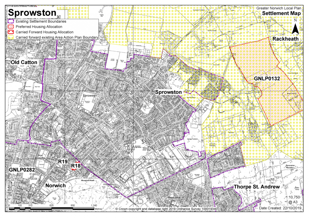
|
POLICY GNLP0132 Land off Blue Boar Lane/Salhouse Road, White House Farm, Sprowston. An area of approximately 66.78 ha is allocated for mixed use. The site is expected to accommodate 1,200 homes, of which 33% will be affordable. The arrangement and interrelationship of different land uses resulting from the development of the site will be established through a participative masterplanning process. The development of the site will be in accordance with the resulting masterplan, which shall be submitted as part of the planning application for the site. The masterplan should clearly demonstrate how the development has been designed to respond to the particular characteristics of the site and to interact and function appropriately with adjacent development sites. The masterplan should demonstrate how homes, jobs, services and facilities have been integrated with walking and cycling, public transport facilities/services, provision for private vehicles and green infrastructure. The masterplan should demonstrate:
|
Note
GNLP0132: This is a large strategic scale greenfield site off Salhouse Road adjacent to a major existing allocation within the North East Growth Triangle. There are no major constraints to make the site unsuitable for development, therefore subject to an acceptable access strategy and masterplan the site is preferred for allocation. The option for the site to incorporate a well-located High School will be investigated further for the submission version of the Plan.
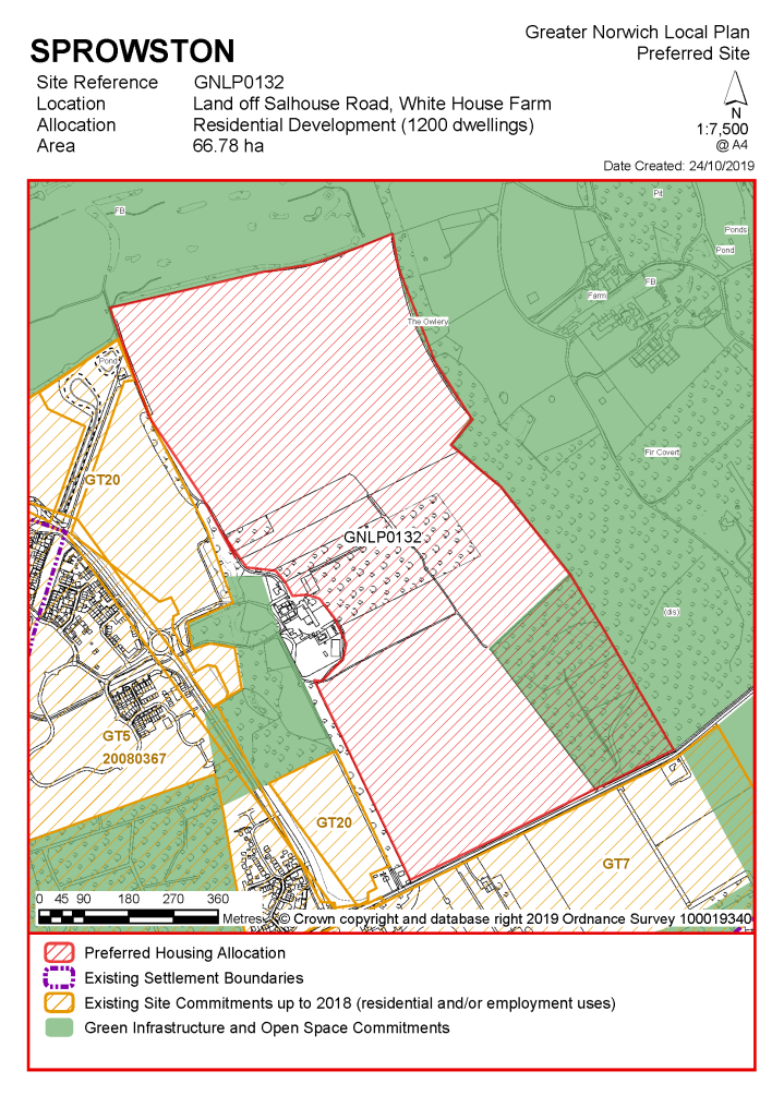
Existing allocation to be carried forward
(1)
Notes
High amounts of existing development commitment remain, as the allocations identified in the Growth Triangle Area Action Plan will not be superseded by the new local plan.
Reasonable Alternatives – Residential
|
Address |
Site Reference |
Area (ha) |
Promoted for |
Reason for not allocating |
|
Sprowston |
||||
|
NO REASONABLE ALTERNATIVE SITES
|
||||
Reasonable Alternatives - Non-Residential
|
Address |
Site Reference |
Area (Ha) |
Proposal |
Reason for not allocating |
|
Sprowston |
||||
| (1) | ||||
|
Sprowston Park and Ride |
GNLP0383 |
5.19 |
High school (or housing if a school is not required). |
|
| (3) | ||||
|
White House Farm |
GNLP3024 |
6.04 |
Multi Use Community Hub |
This proposal is considered to be a reasonable alternative for further consideration if additional community-based facilities are needed in this area of Greater Norwich to support the planned residential development. There is already a farm shop and commercial activities at White House Farm and residential development is located nearby, with additional residential growth planned for the future. However, it is not preferred for allocation at the current time as more evidence is required about the need for the proposal and how the development will come forward. |
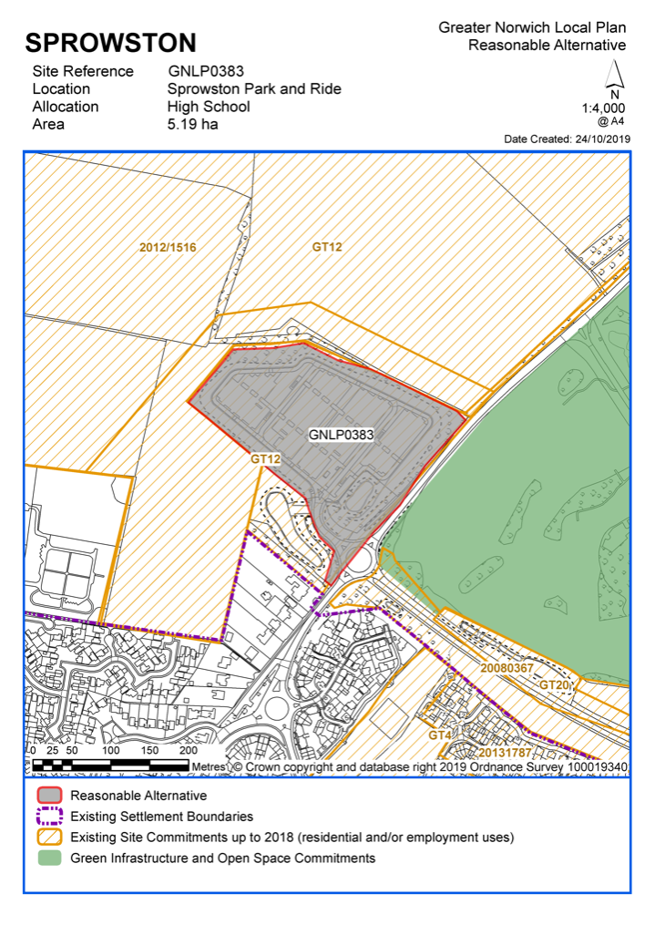
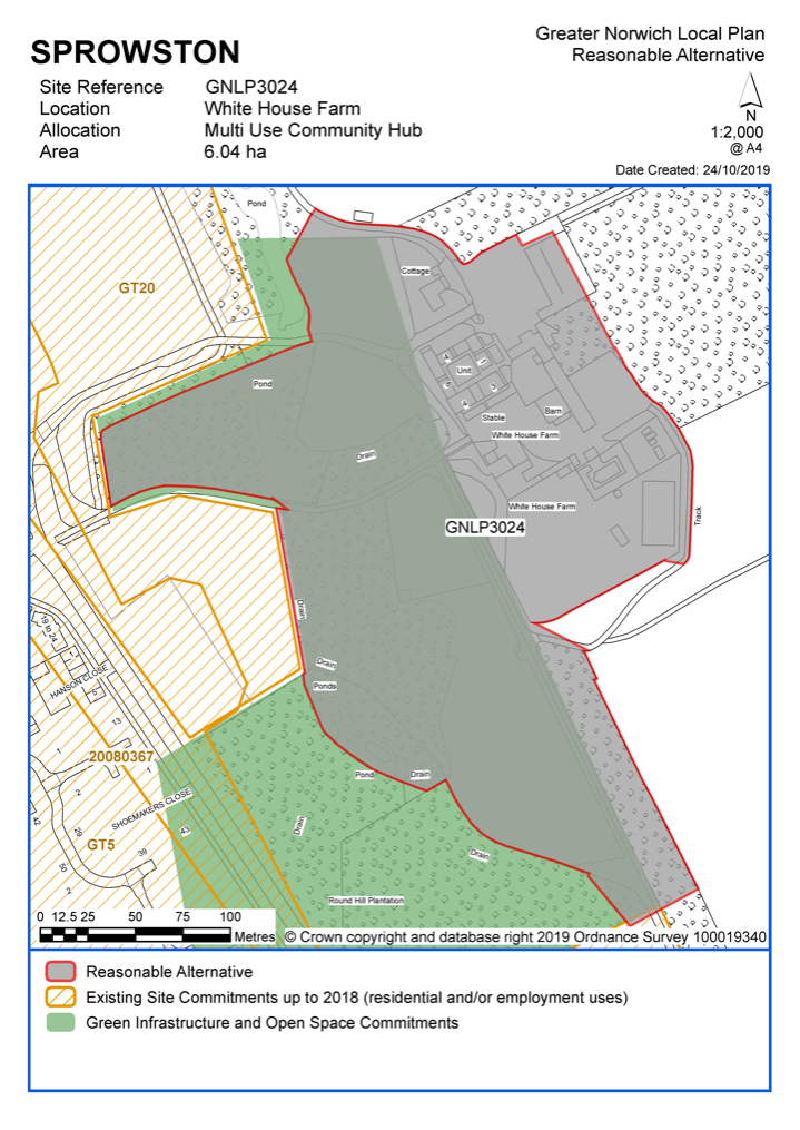
Unreasonable Sites - Residential
|
Address |
Site Reference |
Area (ha) |
Promoted for |
Reason considered to be unreasonable |
|
Sprowston |
||||
| (2) | ||||
|
Land at Rear of Hill Farm House, Wroxham Road |
GNLP0042 |
4.28 |
Residential (unspecified number) |
This site is not suitable for allocation as it is located beyond the settlement and existing commitment. It is considered to be remote, disconnected from services and unsympathetic to the character of the area. |
|
|
||||
| (1) | ||||
|
Lushers Loke |
GNLP2178 |
0.91 |
25 dwellings |
This is a brownfield site bordering a light industrial employment site which may cause compatibility issues. There are concerns about road capacity and lack of footpath provision and there is a high risk of surface water flooding in the south east portion of the site. As it is located within the built-up area it could come forward through the planning application process, so it is not considered for allocation in the local plan. |
|
|
||||
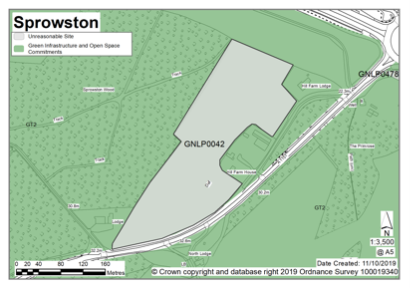
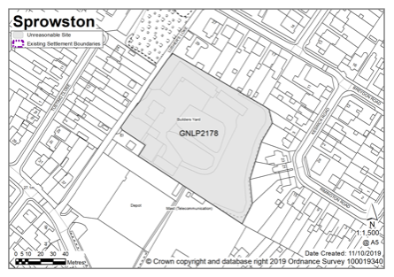
Taverham is identified as a fringe parish. There is a good range of services amongst which is a library and recreation facilities on Sandy Lane; some retail and a pub along the Fakenham Road; Taverham Secondary School is on Beech Avenue; and on Fir Covert Road permission exists for a new supermarket, and other retail to complement the existing garden centre. As to transport, the A1067 Fakenham Road offers good public transport connections to Norwich, and to the north the A1270 Broadland Northway has improved transport connectivity more generally. In terms of the built form and landscape setting of Taverham there are significant blocks of woodland across the parish. The Marriott's Way, the former railway (and now long-distance footpath), takes a north-west to south-east direction, through the parish, defining the landscape, and dividing Taverham from Drayton on its eastern boundary. Of ecological importance, the River Wensum has the status of a Special Area of Conservation (SAC), and also marks Taverham's western and southern boundaries. A neighbourhood plan for Taverham reached its pre-submission stage in 2019.
The parish of Ringland is on the western side of the River Wensum valley and in contrast to Taverham the parish is rural. The settlement of Ringwood is small, consisting of mainly ribbon development along The Street. Facilities are limited, but include parish rooms and a pub. As well as farmland there are several large blocks of woodland, several County Wildlife Sites, and an area of Ancient Woodland (Jennis Wood).
There is one site identified as a preferred option in Taverham providing for 1400 new homes. There are no carried forward allocations but a total of 114 additional dwellings with planning permission on small sites. This gives a total deliverable housing commitment for the cluster of 1514 homes between 2018 – 2038.
There are no sites identified as preferred options in Ringland, no carried forward allocations and one dwelling with planning permission.
All new and carried forward allocations are expected to address standard requirements associated with development. These vary from place to place but are likely to include mitigations for flood risk (as well as SUDs), highways improvements, safeguarding of minerals resources, land remediation, measures to protect the environment, biodiversity, and landscape intrusion.
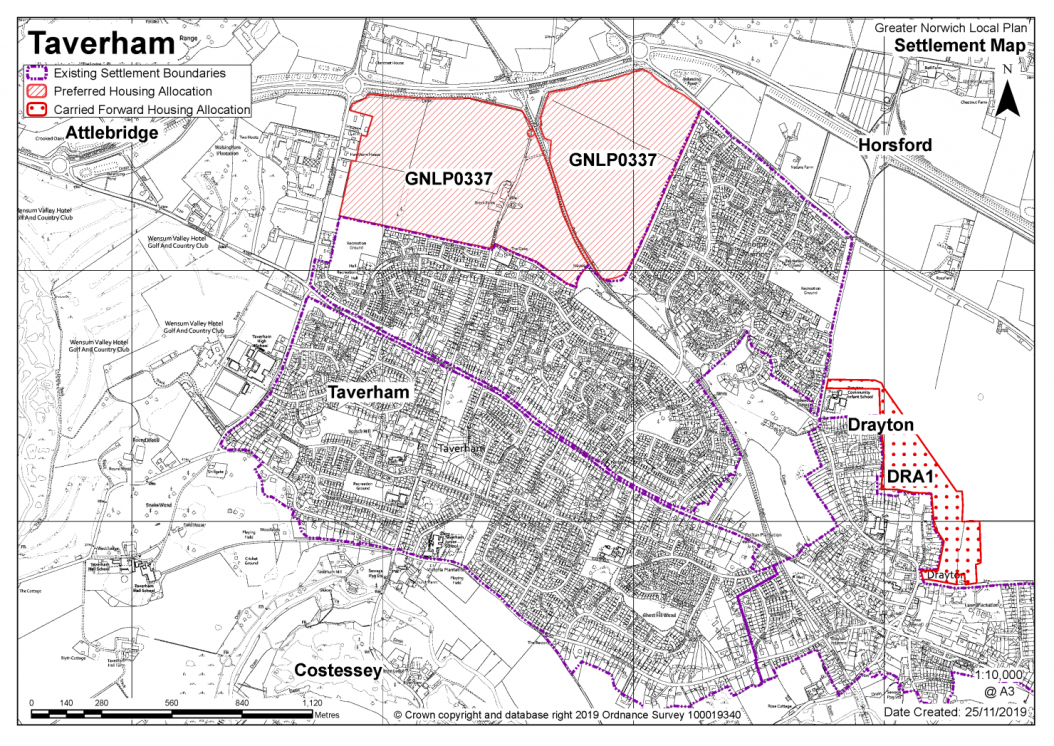
|
POLICY GNLP0337 Land between Fir Covert Road and Reepham Road, Taverham (78.36 ha) is allocated for residential development. The site is likely to accommodate at least 1,400 homes, 33% of which will be affordable, associated public open space, new primary school and local medical centre.
More homes may be accommodated, subject to an acceptable design and layout, as well as infrastructure constraints.
The development will be expected to address the following specific matters:
The masterplan should demonstrate:
|
Notes
GNLP0337: This is a strategic-scale site well-related to the existing edge of Thorpe Marriott with no major constraints to make the site unsuitable for development. The site will need to be masterplanned to provide community and recreation facilities including a school and medical care facility. Highway improvements will be needed including provision of roundabout access at Fir Covert Road, priority access at Reepham Road and traffic signals at the A1067 Fakenham Road/Fir Covert Road.
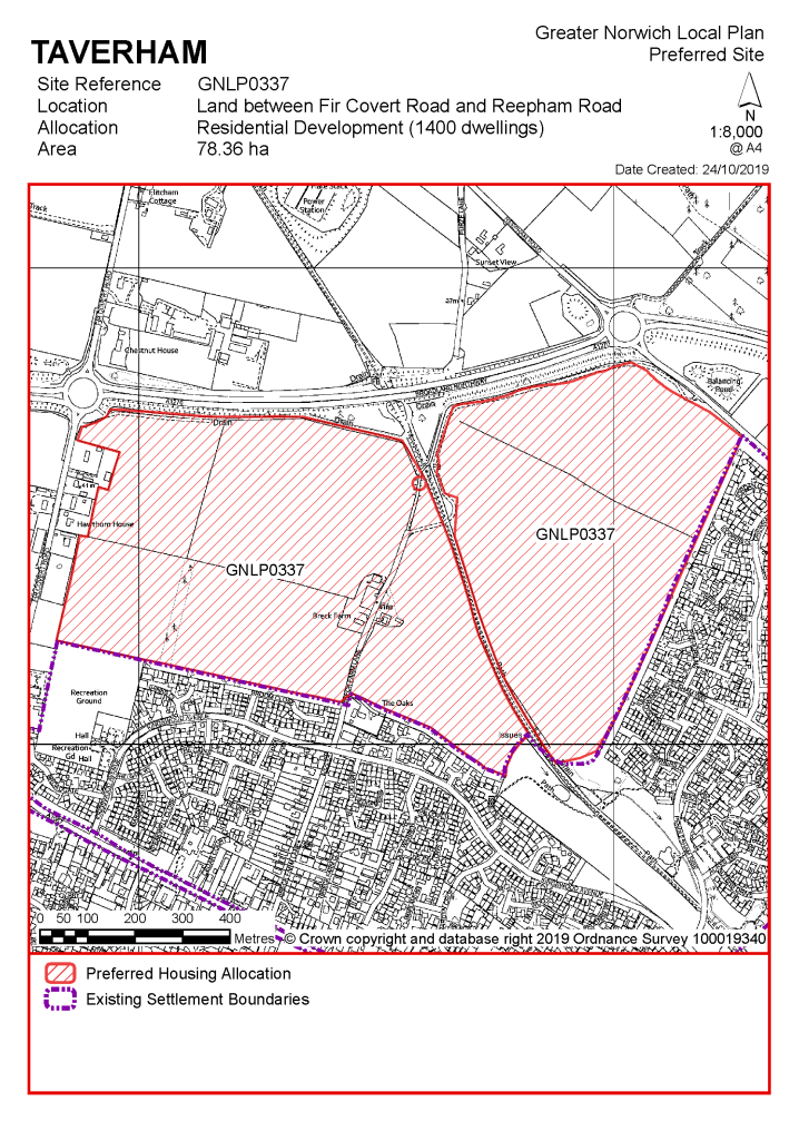
No existing allocations to be carried forward
Notes
TAV 1: The retail-led development next to Taverham Garden Centre has planning permission (20171782). TAV1 will be incorporated into the Settlement Limit once it is completed.
|
Address |
Site Reference |
Area (ha) |
Promoted for |
Reason for not allocating |
|
Taverham and Ringland |
||||
| (1) | ||||
|
Land adjacent to Beech Avenue Business Park, Ringland Road |
GNLP0159 |
11.31 |
150-200 dwellings |
The eastern part of this larger site is considered to be a reasonable alternative if additional housing is needed in the urban area. To be acceptable it would have to be developed in conjunction with either the planning permission on the northern part of the site (20172148) or neighbouring site GNLP0457 which also has consent. The western part of the site is considered to be unsuitable for residential development due to tree, landscape and townscape considerations. |
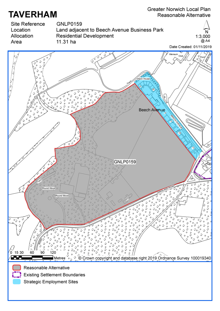
Unreasonable Sites - Residential
|
Address |
Site Reference |
Area (ha) |
Promoted for |
Reason considered to be unreasonable |
|
Taverham and Ringland |
||||
| (3) | ||||
|
Field at Taverham Road, Taverham |
GNLP0062 |
6.14 |
Mixed use 144 dwellings, community technology hub, drainage and services infrastructure |
This site is located on the undeveloped south side of Taverham Road, development here would intrude into and have a significantly harmful visual impact on the Wensum Valley and so therefore the site is not considered to be suitable for allocation. |
|
|
||||
|
Land at Beech Avenue |
GNLP0457 |
2.67 |
50 dwellings |
This site already has planning permission (reference 20172148). This permission will be counted in development commitment figure so it is not proposed to allocate the site in the local plan |
|
|
||||
| (5) | ||||
|
151 Taverham Road |
GNLP2051 |
1.31 |
Residential (unspecified number) |
This site is not considered to be suitable for allocation as there is insufficient frontage to form a safe access. The site is also constrained by adverse landscape impacts. |
|
|
||||
| (1) | ||||
|
South of Taverham Road |
GNLP2106 |
3.30 |
70 dwellings |
This site is not considered to be suitable for allocation as it is not feasible to provide a safe access/route to A1067, and there are limited opportunities for pedestrian footways. The site is also constrained by adverse landscape impacts, development in this location would be detrimental to the appearance of the Wensum Valley and the Old Costessey Conservation Area. |
|
|
||||
|
Weston Road, Ringland |
GNLP3039 |
0.87 |
1 dwelling |
This site is not considered to be suitable for allocation as it is remote from the nearest services in Taverham, including the absence of a safe walking route to school. The local road network is substandard and there would be difficulty in achieving access from narrow village roads. |
|
|
||||
|
South of The Street, Ringland |
GNLP3040 |
0.50 |
5 dwellings |
This site is not considered to be suitable for allocation as it is remote from the nearest services in Taverham, including the absence of a safe walking route to school. The local road network is substandard and there would be difficulty in achieving access from narrow village roads. |
|
|
||||
|
South of The Street, Ringland |
GNLP3041 |
1.12 |
5 dwellings |
This site is not considered to be suitable for allocation as it is remote from the nearest services in Taverham, including the absence of a safe walking route to school. The local road network is substandard and there would be difficulty in achieving access from narrow village roads. |
|
|
||||
|
Land facing The Street, Ringland |
GNLP3043 |
0.90 |
1 dwelling |
This site is not considered to be suitable for allocation as it is remote from the nearest services in Taverham, including the absence of a safe walking route to school. The local road network is substandard and there would be difficulty in achieving access from narrow village roads. |
|
|
||||
|
Costessey Lane, Ringland |
GNLP3045 |
0.53 |
5 dwellings |
This site is not considered to be suitable for allocation as it is remote from the nearest services in Taverham, including the absence of a safe walking route to school. The local road network is substandard and there would be difficulty in achieving access from narrow village roads. |
|
|
||||
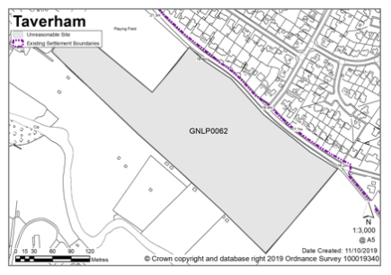
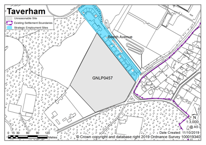
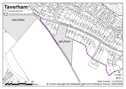
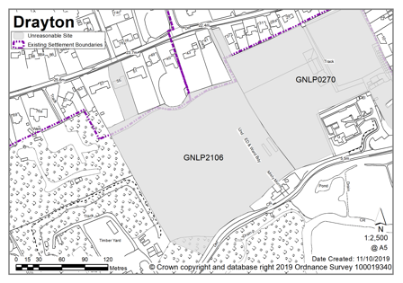
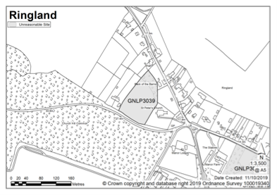
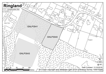
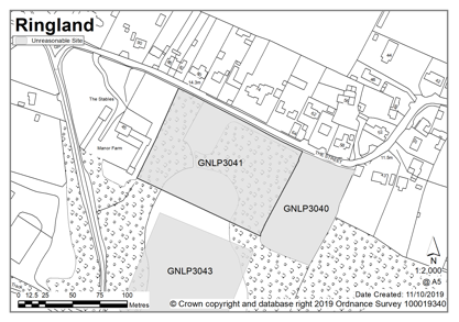
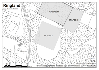
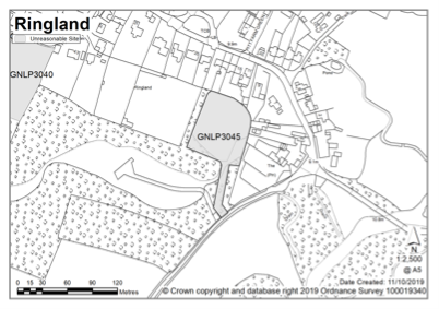
Thorpe St Andrew is an urban fringe parish and is within an area identified for significant development as part of the Growth Triangle Area Action Plan. The suburban character of Thorpe St Andrew comprises mainly 20th Century semi-detached and detached properties often set in large plots with mature planting. The Thorpe St Andrew Conservation Area extends northwards from the River Yare up the valley side to the top of Thorpe Ridge.
Thorpe St Andrew also benefits from a good range of services and facilities, principally based around the district centre at Pound Lane that is anchored by a Sainsbury supermarket. There is primary school provision within the town council area and Thorpe St Andrew High School has approximately 1,700 students, including a sixth form. Historically, Thorpe St Andrew developed along the Yarmouth Road parallel to the north bank of the River Yare. Historic listed buildings line the Yarmouth Road, including the Grade II* Thorpe Hall and the ruins to the Church of St Andrew.
There are no sites identified as preferred options in Thorpe St Andrew. There are no carried forward allocations but a total of 354 additional dwellings with planning permission. This gives a total deliverable housing commitment for Thorpe St Andrew of 354 homes between 2018 – 2038.
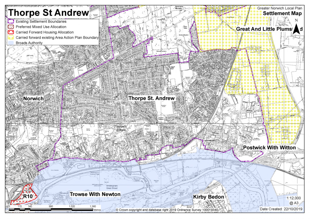
No existing allocations to be carried forward
Notes:
Thorpe St Andrew is affected by the Growth Triangle Area Action Plan (AAP) which will not be superseded by this plan. These are AAP schemes at the edge of the town council's administrative area, at Brook Farm (GT 6) and north of Plumstead Road (GT 8); as well as allocations related to employment at Broadland Business Park. Other Thorpe St Andrew sites allocated in 2015 are now implemented, such as TSA2 at the former Pinebanks and TSA3 at Griffin Lane, and so are not carried forward for reallocation.
|
Address |
Site Reference |
Area (ha) |
Promoted for |
Reason for not allocating |
|
Thorpe St Andrew |
||||
|
NO REASONABLE ALTERNATIVE SITES
|
||||
Unreasonable Sites - Residential
|
Address |
Site Reference |
Area (ha) |
Promoted for |
Reason considered to be unreasonable |
|
Thorpe St Andrew |
||||
|
Land to the East side of Woodside Road (Thorpe Woodland) |
GNLP0228 |
10.48 |
Mixed use (unspecified number) (provides links to Woodside to development to north east of the site) |
This site is considered to be unreasonable for allocation as there are other more preferable sites to consider which do not involve the loss of a county wildlife site and which have less ecological and biodiversity impacts. This site also has issues with surface water flood risk. |
|
|
||||
| (3) | ||||
|
Racecourse Plantations, Plumstead Road East |
GNLP0442 |
70.22 |
10 ha for up to 330 dwellings with remainder of the site designated as a community wood land park |
This site is well related to services and the form and character of the area. It was allowed on appeal in January 2019 (reference 20168996) for 300 homes and the creation of a new Community Woodland Park, so it is not proposed to allocate the site in the local plan. |
|
|
||||
|
Oasis Sport and Leisure Centre, 4 Pound Lane |
GNLP0540 |
3.03 |
Redevelopment of Oasis Leisure Club including erection of replacement spa and wellbeing club and erection of 27 residential dwellings |
This site is within the settlement limit where development is acceptable in principle providing it does not result in any significant adverse impact. The site was granted on appeal in February 2017 (reference 20151132) so it is not proposed to allocate the site in the local plan. |
|
|
||||
| (1) | ||||
|
Langley North (former playing fields/Langley School) |
GNLP2170 |
1.33 |
40 dwellings |
This site is within the settlement limit where development is acceptable in principle providing it does not result in any significant adverse impact. Sport England has objected stating that the area of playing field to be lost as a result of development should be replaced prior to commencement. The site is considered to be unsuitable for allocation, as site constraints prevent formation of an acceptable vehicular access. |
|
|
||||
| (1) | ||||
|
Langley South (former Langley School) |
GNLP2171 |
4.38 |
70 dwellings |
This site is within the settlement limit where development is acceptable in principle providing it does not result in any significant adverse impact. Half of the site is Ancient Woodland which is a significant constraint. The site is considered to be unsuitable for allocation, as site constraints prevent formation of an acceptable vehicular access. |
|
|
||||
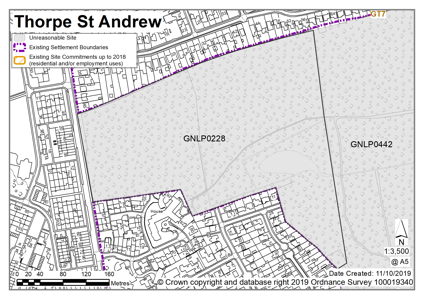
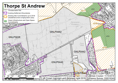
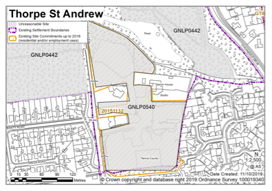
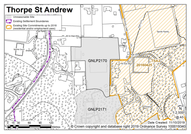
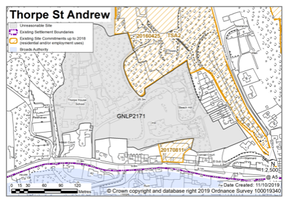
TROWSE (Including non-residential at Bixley and Whitlingham)
Trowse and Newton is identified as urban fringe parish. Facilities in the village include a primary school, a small convenience store, two pubs, and a community building. Trowse village enjoys the benefits of being next to Whitlingham Country Park and close to employment opportunities within Norwich City.
There are various historic buildings, the most notable being the Grade I Church of St Andrew. An important part of the village's history is its connection to the Colman's family. Trowse is an example of a model village and that history is still evident in the workers' terraced cottages. There are existing allocations and planning permissions in place for development in Trowse, which includes plans to construct a 210-pupil primary school. In addition, part of the Deal Ground site (former industrial land) falls within the Trowse parish boundary, with the majority in Norwich City Council's boundary.
There are no sites identified as preferred options in Trowse. There is one carried forward allocation providing for 173 new homes and a total of 71 additional dwellings with planning permission. This gives a total deliverable housing commitment for Trowse of 244 homes between 2018 – 2038.
All new and carried forward allocations are expected to address standard requirements associated with development. These vary from place to place, but are likely to include mitigations for flood risk (as well as SUDs), highways improvements, safeguarding of minerals resources, land remediation, measures to protect the environment, biodiversity, and landscape intrusion.
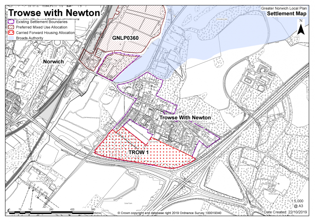
No new allocations are proposed
Notes:
In addition to the existing commitment for development the A47/A146 road network and River Yare constrain expansion of Trowse village.
Existing allocation to be carried forward
|
POLICY TROW 1 Land on White Horse Lane and to the rear of Charolais Close & Devon Way (approx. 9 ha) is allocated for residential development with new primary school. This will accommodate approximately 173 homes.
The development will be expected to address the following specific matters:
|
Notes
TROW 1: The allocated site benefits from planning permission for 173 dwellings, with land set aside for the future development of a primary school on the site. Reserved matters permission for 98 units (ref. 2016/0803 and 2016/0805) is currently under construction and a subsequent reserved matters application for 75 dwellings on the remainder of the site is undetermined at the time of preparing this draft plan (ref. 2017/2670). The principle of development on the site has already been accepted and it is expected that development will take place within the time-period of this local plan. The site is re-allocated for residential development. As an existing allocation it has been considered in the calculation of the housing requirement. The site is likely to accommodate approximately 173 homes, subject to an acceptable design and layout, etc.
Reasonable Alternatives - Residential
|
Address |
Site Reference |
Area (ha) |
Promoted for |
Reason for not allocating |
|
Trowse |
||||
|
NO REASONABLE ALTERNATIVE SITES
|
||||
Reasonable Alternatives - Non-Residential
|
Address |
Site Reference |
Area (Ha) |
Proposal |
Reason for not allocating |
|
|
Trowse (including Bixley and Whitlingham) |
|||||
| (2) | |||||
|
Land at junction Loddon Road/Bungay Road, Bixley |
GNLP3051 |
7.91 |
Park and Ride Site |
This proposal is considered to be a reasonable alternative for further consideration. The future need for this site depends on the overarching Transport for Norwich strategy and the long-term plan for the provision of park and ride facilities to serve the local area. The submission document hints at the possibility of retail, restaurant and petrol filling station uses, but no detail on such facilities is included as yet. |
|
| (2) | |||||
|
Land at and adjacent to Whitlingham Country Park |
GNLP3052 |
200.00 |
Recreation and tourism associated with the existing Country Park |
This proposal is considered to be a reasonable alternative for further consideration but is not preferred for allocation at the current time as more details are required about the exact nature of the plans. The land promoted is also mostly within the Broads Authority administrative area, for which there are policies relating to Whitlingham Country Park. |
|
|
Address |
Site Reference |
Area (ha) |
Promoted for |
Reason considered to be unreasonable |
|
Trowse |
||||
|
NO UNREASONABLE SITES |
||||