Draft Local Plan-Part 2 Site Allocations
MAIN TOWNS
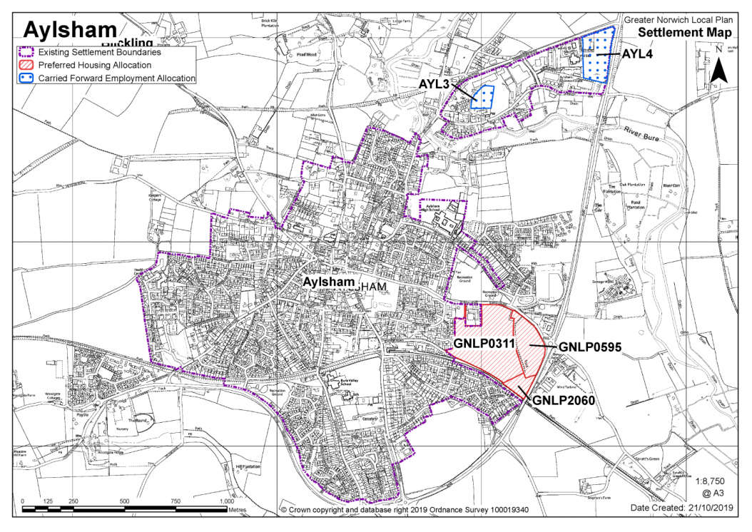
AYLSHAM (including Blicking, Burgh & Tuttington and Oulton)
Aylsham is classified as a Main Town. At the heart of the town is the Market Place that is well-known for its weekly Friday market, and regular Farmers' markets. Important streets, for historic buildings and for trade in Aylsham, include Hungate Street, Penfold Street, and Red Lion Street. The extensive conservation area in Aylsham stretches from the Manor House on Norwich Road to Millgate at the north; but, also to the north-west of the town, the Blicking conservation area extends southwards to the north-west edge of the town. As to landscape matters, the River Bure flows to the north and around to the south-east of the town. To the south and east of the town, the B1145 Cawston Road and A140 Cromer Road are also important in defining the built edges of Aylsham. In terms of current development, both the Woodgate Farm scheme at the west of the town and the Bure Meadows scheme near the High School are well-advanced.
Aylsham Neighbourhood Plan was 'made' in July 2019 and covers the period to 2038. The vision for the Aylsham Neighbourhood Plan states that 'the market town of Aylsham is renowned for its individuality and historical importance. It is vital that these are protected whilst promoting its unique character, excellent location and strong sense of community.' The Plan seeks to do this through a series of objectives and policies that shape development within the neighbourhood area. The plan contains policies based on themes around housing, environment, economy, recreation and infrastructure.
There is one site identified as a preferred option in Aylsham providing for 300 new homes. There are no carried forward allocations but a total of 225 additional dwellings with planning permission. This gives a total deliverable housing commitment for Aylsham of 525 homes between 2018 – 2038.
All new and carried forward allocations are expected to address standard requirements associated with development. These vary from place to place, but are likely to include mitigations for flood risk (as well as SUDs), highways improvements, safeguarding of minerals resources, land remediation, measures to protect the environment, biodiversity, and landscape intrusion.
|
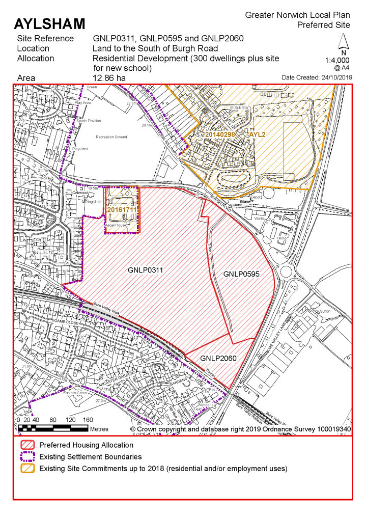
POLICY GNLP0311, 0595 and 2060 Land south of Burgh Road and west of the A140, Aylsham (approx. 12.86 ha) is allocated for residential development. The site is likely to accommodate at least 300 homes, 33% of which will be affordable, and new primary school.
More homes may be accommodated, subject to an acceptable design and layout, as well as infrastructure constraints.
The development will be expected to address the following specific matters:
|
Notes
GNLP0311, 0595 and 2060: There are a number of similarly performing sites put forward in Aylsham but this combination of sites is favoured for allocation as it is preferred in highway terms as long as two points of access are provided. The site allocation includes a requirement for a new primary school in Aylsham required to meet growth needs.
Existing allocation to be carried forward
|
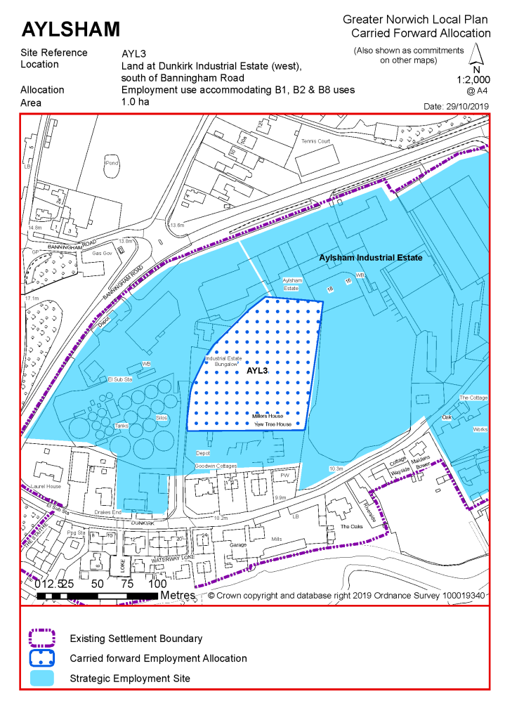
POLICY AYL3 Land at Dunkirk Industrial Estate (west), south of Banningham Road, Aylsham (of approx. 1.0 ha) is allocated for employment use. This will accommodate B1, B2 & B8 uses.
The development will be expected to address the following specific matters:
|
Notes
AYL3: The site was allocated in 2016 as part of the current local plan but has not yet been developed. The principle of development is already accepted, and it is expected that development will take place within the new local plan time-period up to 2038. The site is re-allocated for employment development.
|
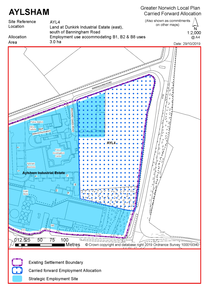
POLICY AYL4 Land at Dunkirk Industrial Estate (east), south of Banningham Road, Aylsham (of approx. 3.0 ha) is allocated for employment use. This will accommodate B1, B2 & B8 uses.
The development will be expected to address the following specific matter:
|
Notes
AYL4: The site was allocated in 2016 as part of the current local plan but has not yet been developed. The principle of development is already accepted, and it is expected that development will take place within the new local plan time-period up to 2038. The site is re-allocated for employment development.
|
Address |
Site Reference |
Area (ha) |
Proposal |
Reason for not allocating |
|
Aylsham (Blicking, Burgh & Tuttington and Oulton) |
||||
| (6) | ||||
|
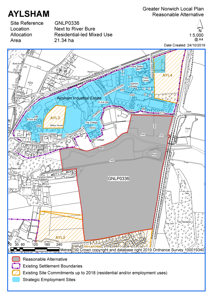
Next to River Bure |
GNLP0336 |
21.34 |
Residential development of approx. 300 dwellings, a neighbourhood centre to include community and retail uses, a primary school, public open space, play areas, a Riverside County Park and new footpath links |
This site is considered to be a reasonable alternative if additional growth is needed in the towns, subject to a satisfactory access strategy via existing allocation AYL2. A new school site is needed in Aylsham which is promoted as part of this scheme, however more evidence is needed regarding delivery. The potential to deliver a school on this site needs to be balanced against the fact that there are considered to be other more preferable sites for allocation in the town on highways grounds. This site is therefore of secondary preference for allocation in the town. The site does have some constraints including a large area in flood zones 2 and 3, impact on the Bure Valley landscape and heritage issues. |
| (10) | ||||
|
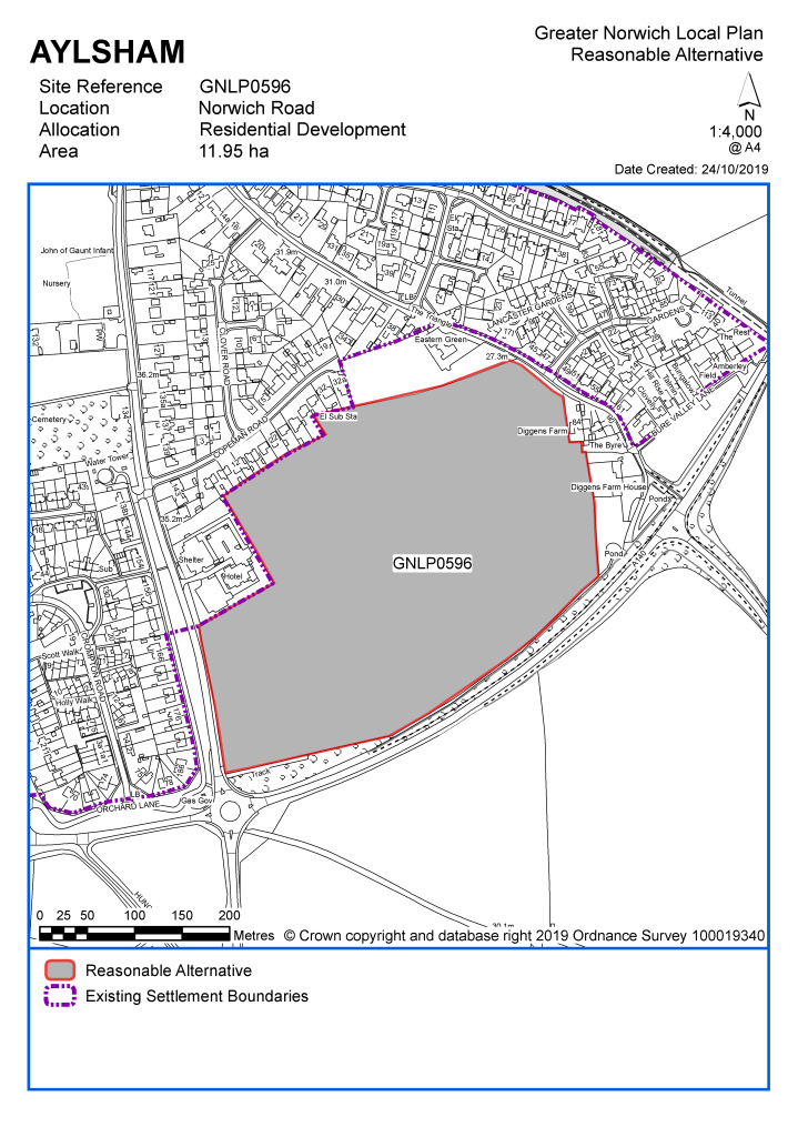
Norwich Road |
GNLP0596 |
11.95 |
Residential development for approx. 250 dwellings |
This site is considered to be a reasonable alternative if additional growth is needed in the towns, subject to mitigation measures. For highways reasons, requirements would include a maximum of 100 dwellings with access from Norwich Road and a 2 metre wide footpath across the site frontage. 250 dwellings would require two points of access, but this would require further investigation as it would not be possible from either Copeman Road or Buxton Road. This site is therefore of secondary preference for allocation in the town. |
Unreasonable Sites - Residential
|
Address |
Site Reference |
Area (ha) |
Promoted for |
Reason considered to be unreasonable |
|
Aylsham (Blicking, Burgh & Tuttington and Oulton) |
||||
| (4) | ||||
|
North of Marriotts Way |
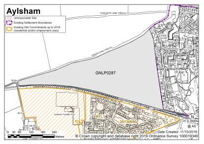
GNLP0287 |
12.85 |
Residential development of approx. 250 houses and 2.35ha of public open space for recreation and leisure |
This site is not considered to be suitable for allocation as it is located on the western edge of the town, less centrally placed than the preferred and reasonable alternative sites. The site appears to be significantly constrained if there is a requirement to cross the Marriotts Way which is a County Wildlife Site and green infrastructure asset. |
|
|
||||
| (2) | ||||
|
B1145 Henry Page Road/ Norwich Road |
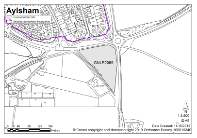
GNLP2059 |
1.32 |
15-20 dwellings |
This site is not considered to be suitable for allocation as it is located outside the clear built form of the town. Residential development here would appear as a separate enclave divorced from the town and less well related to form and character than the other sites promoted. |
|
|
||||
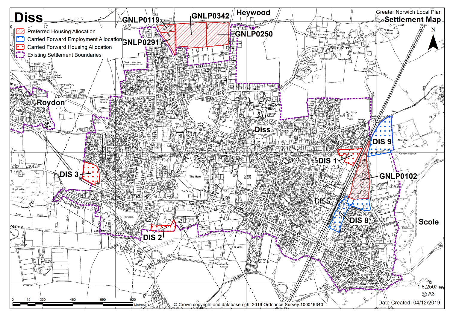
DISS (including part of Roydon)
Diss is identified as a Main Town in the GNLP, with a wide range of services and facilities available. The town is located to the north west of the junction of the A140 and A143 and is on the main Norwich-Ipswich-London rail line. As such, the town is well located for new development, subject to the constraints identified below. In addition to having a good range of shops and facilities in the town centre, there is a concentration of commercial and industrial businesses to the east of the town (located either side of the railway), with further land allocated for expansion. Further afield, approximately three miles from the town, near Eye, is the Mid Suffolk Business Park which also offers significant employment opportunities.
There are particular vehicular pressures on the A1066 Victoria Road and B1077 Denmark Street as they pass through the town, with congestion considered a barrier to significant growth. There is an attractive historic town centre within an extensive conservation area, that extends to Sunnyside at the north and Park Road to the south. The historic core of Diss is formed by the Market Place, Market Hill, and St Nicholas Street and the town includes an exceptional concentration of listed buildings. A number of open spaces are located within the heart of the town, including The Mere and adjacent park, as well as private open land that contributes significantly to the character and which are protected as Important Local Open Spaces.
In terms of the environmental and landscape considerations, the River Waveney is to the south and the Frenze Valley landscape lies to the east and southeast; the former marks the administrative boundary with Mid-Suffolk and Suffolk County Council and the latter including a string of County Wildlife Sites. The plan seeks to avoid the coalescence of Diss with the nearby villages, particularly Roydon to the west. As such, the scope for expansion of the town through this plan is constrained. In terms of new housing, amongst the schemes currently under construction is the DIS 4 allocation on Frenze Hall Lane.
In 2018 early consultations took place on the Diss & District Neighbourhood Plan. The proposed Diss & District Neighbourhood Plan is a cross boundary plan covering parishes located within both the South Norfolk and Mid-Suffolk districts. The parishes included in the production of the Neighbourhood Plan are: Brome and Oakley, Burston and Shimpling, Diss, Palgrave, Roydon, Scole and Stuston.
There are two sites identified as preferred options in Diss providing for 400 new homes. There are three carried forward allocations providing for 87 new homes and a total of 256 additional dwellings with planning permission. This gives a total deliverable housing commitment for Diss (including part of Roydon) of 743 homes between 2018 – 2038.
All new and carried forward allocations are expected to address standard requirements associated with development. These vary from place to place, but are likely to include mitigations for flood risk (as well as SUDs), highways improvements, safeguarding of minerals resources, land remediation, measures to protect the environment, biodiversity, and landscape intrusion.
|
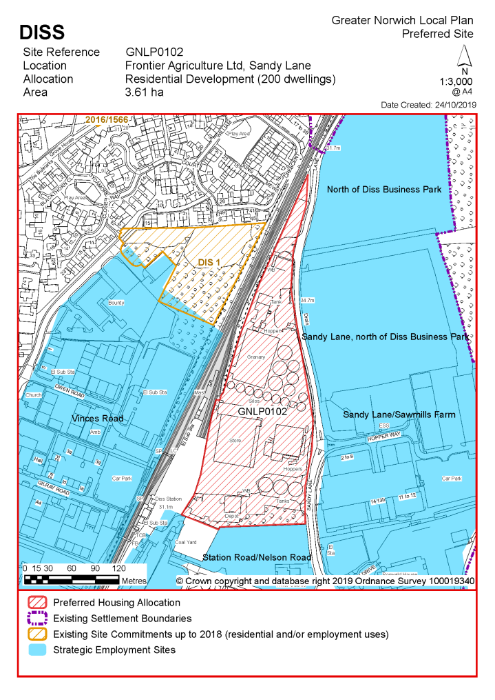
POLICY GNLP0102 Land at Frontier Agriculture Ltd, Sandy Lane, Diss (approx. 3.61 ha) is allocated for residential development. The site is likely to accommodate at least 200 homes, 33% of which will be affordable. More homes may be accommodated, subject to an acceptable design and layout being achieved.
The development will be expected to address the following specific matters:
|
Notes
GNLP0102: This site is preferred for allocation as it is a brownfield site close to the railway station. Its location means that medium to high density development is likely to be achievable. The timing of site development will be dependent on the relocation of existing employment uses.
|
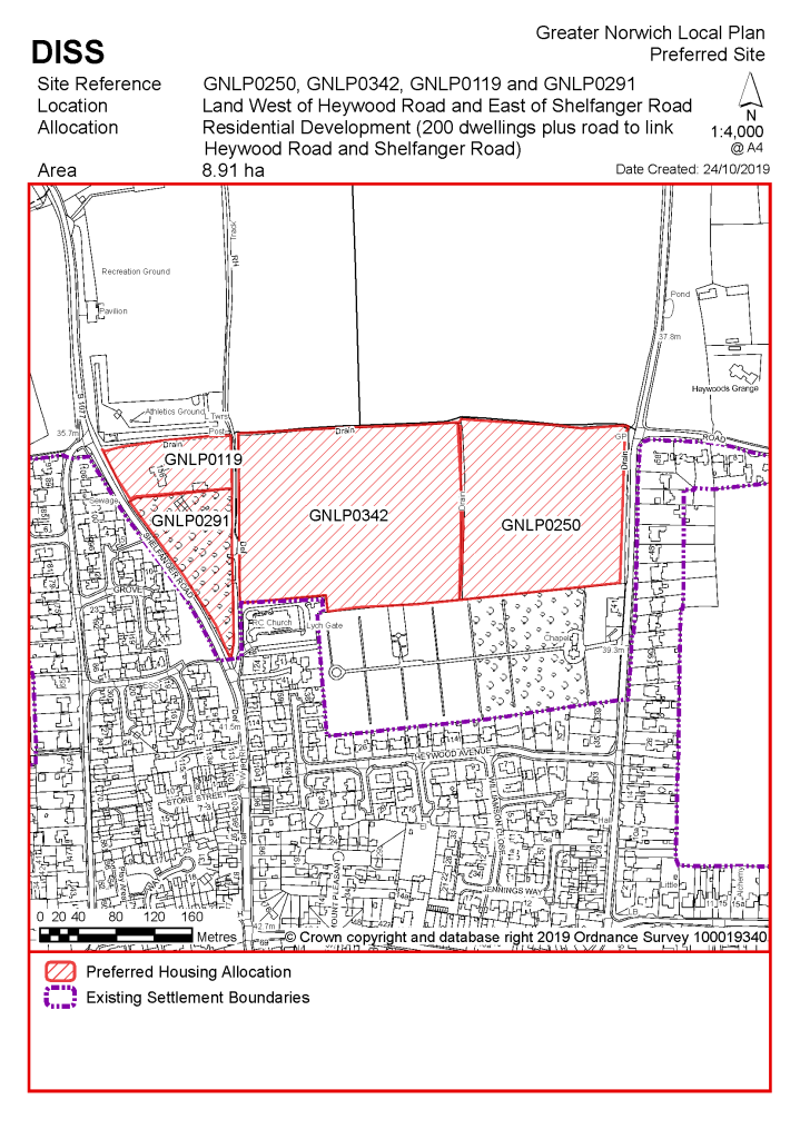
POLICY GNLP0250/0342/0119/0291, land north of the Cemetery, west of Shelfanger Road and East of Heywood Road, Diss (approx. 8.91 ha) is allocated for residential development. The site is likely to accommodate at least 200 homes, 33% of which will be affordable. More homes may be accommodated, subject to an acceptable design and layout being achieved and relevant infrastructure issues being addressed.
The development will be expected to address the following specific matters:
|
Notes
GNLP0250/0342/0119/0291: This combination of sites is preferred for allocation as they are well related in form and character terms to the existing built up area of Diss and would enable the provision of a link road to connect Heywood Road and Shelfanger Road, which may alleviate some existing traffic problems. Development would need to be supported by a Transport Assessment.
Existing allocation to be carried forward
|
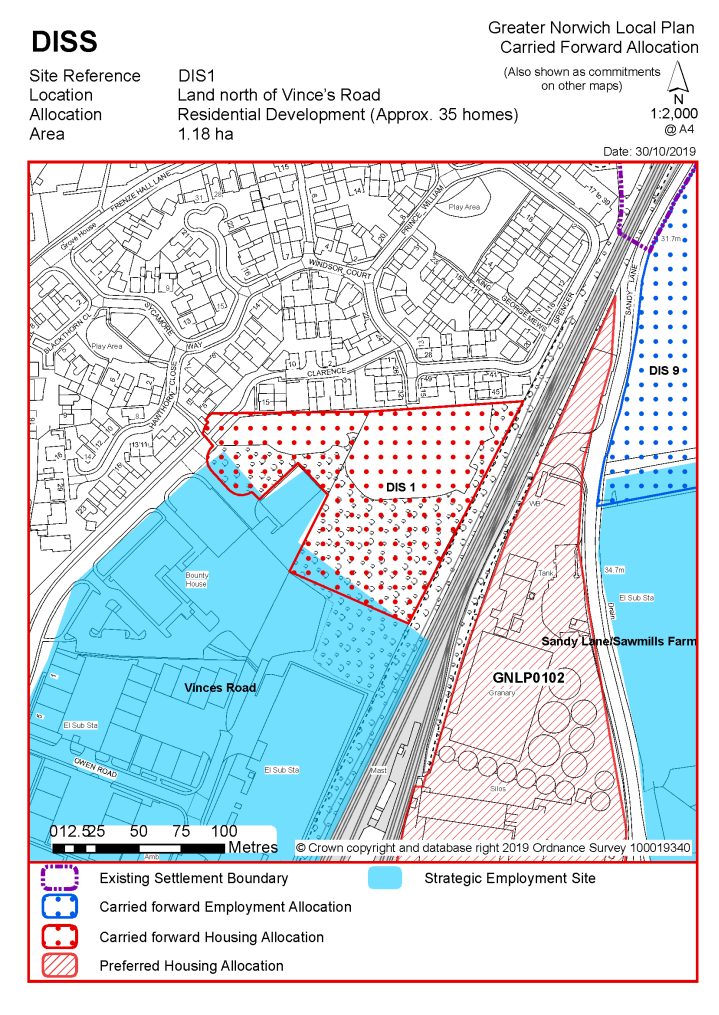
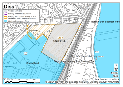
POLICY DIS 1 Land north of Vince's Road, Diss (approx. 1.18 ha) is allocated for residential development. The site will accommodate approximately 35 homes.
The development will be expected to address the following specific matters:
|
Notes
DIS 1: The site was allocated in 2015 as part of the current local plan but has not yet been developed. The principle of development is already accepted and it is expected that development will take place within the new local plan time-period. The site is considered in the calculation of the housing requirement, providing at least 35 homes, but more may be accommodated, subject to an acceptable design and layout, etc. being achieved.
|
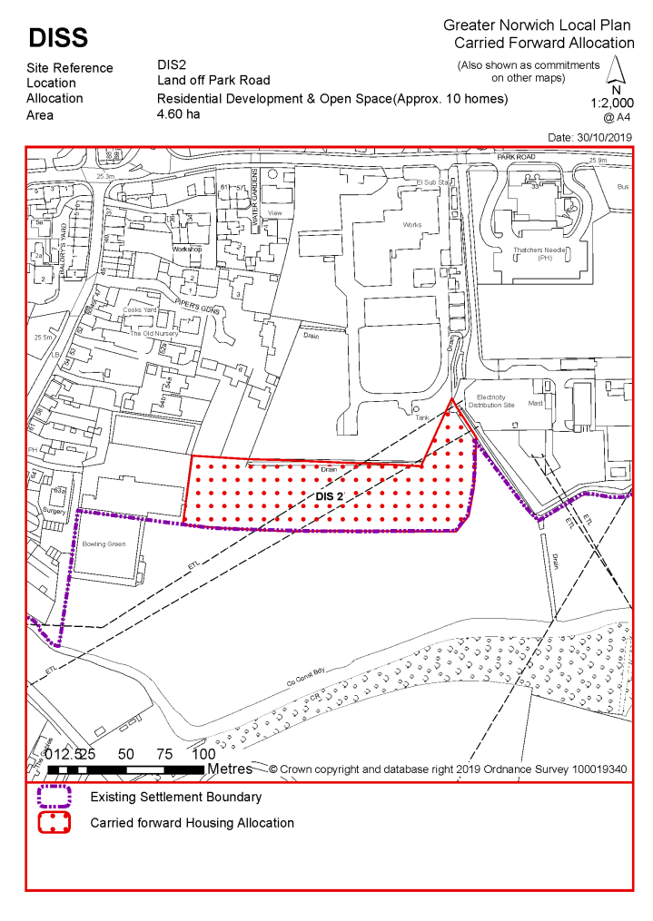
POLICY DIS 2 Land off Park Road, Diss (approx. 4.6 ha) is allocated for open space and residential development. This will accommodate approximately 10 homes.
The development will be expected to address the following specific matters:
|
Notes
DIS 2: The site was allocated in 2015 as part of the current local plan but has not yet been developed. The principle of development is already accepted and it is expected that development will take place within the new local plan time-period. The site is considered in the calculation of the housing requirement, providing at least 10 homes, but more may be accommodated, subject to an acceptable design and layout, etc. being achieved.
|
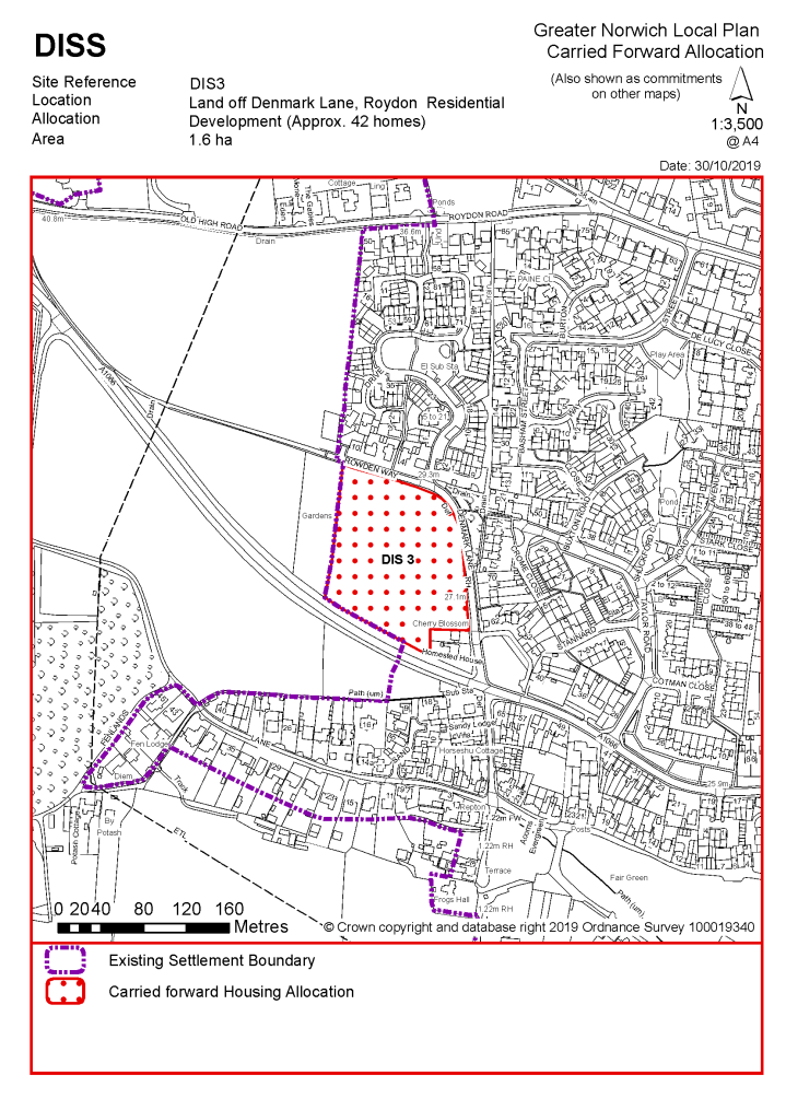
POLICY DIS 3 Land off Denmark Lane, Roydon, Diss (approx. 1.6 ha) is allocated for residential development. This will accommodate approximately 42 homes. More homes may be accommodated, subject to an acceptable design and layout, as well as infrastructure constraints. The development will be expected to address the following specific matters:
|
Notes
DIS 3: The site was allocated in 2015 as part of the current local plan but has not yet been developed. The principle of development is already accepted and it is expected that development will take place within the new local plan time-period. The site is considered in the calculation of the housing requirement, providing at least 42 homes, but more may be accommodated, subject to an acceptable design and layout, etc. being achieved.
|
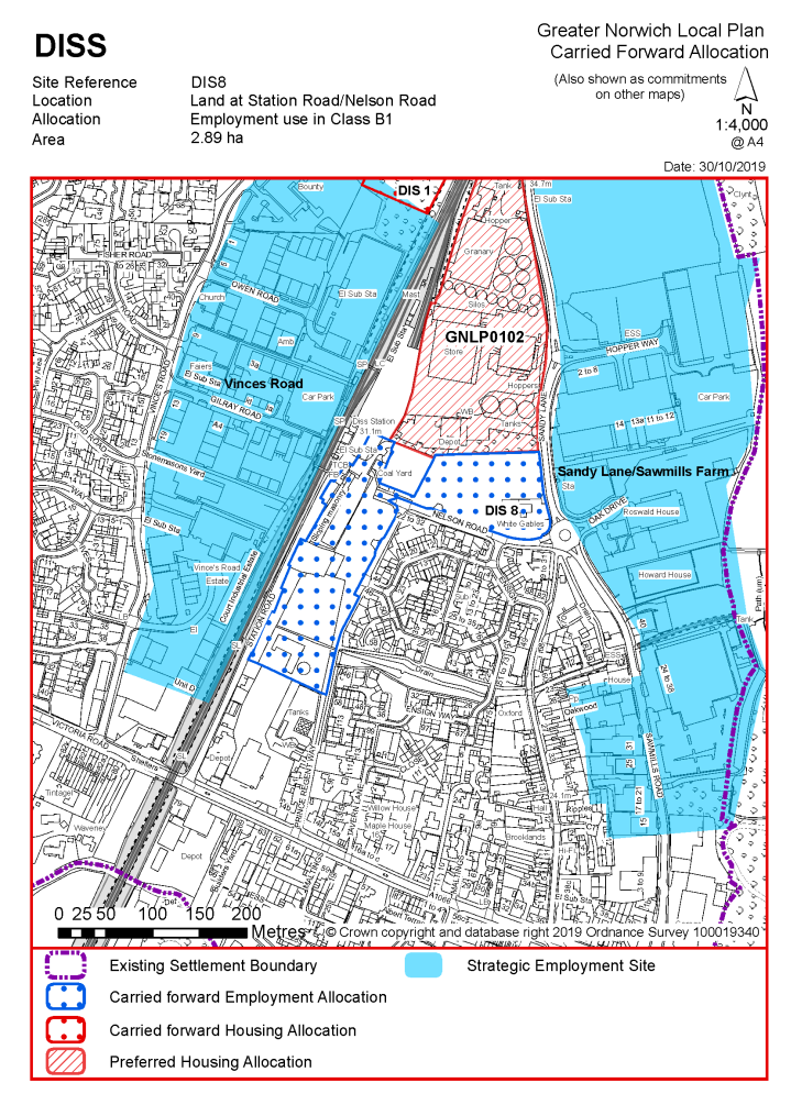
POLICY DIS 8 Land at Station Road/Nelson Road, Diss (approx. 2.89 ha) is allocated for employment uses in Class B1.
The development will be expected to address the following specific matters:
|
Notes
DIS 8: The site was allocated in 2015 as part of the current local plan but has not yet been developed. The principle of development is already accepted and it is expected that development will take place within the new local plan time-period. The site is re-allocated for employment/commercial development.
|
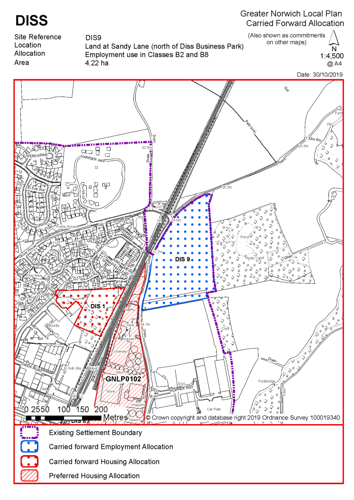
POLICY DIS 9 Land at Sandy Lane (north of Diss Business Park), Diss (approx. 4.22 ha) is allocated for employment uses un Classes B2 and B8.
The development will be expected to address the following specific matters:
|
Notes
DIS 9: The site was allocated in 2015 as part of the current local plan but has not yet been developed. The principle of development is already accepted and it is expected that development will take place within the new local plan time-period. The site is re-allocated for employment/commercial development.
|
Address |
Site Reference |
Area (ha) |
Proposal |
Reason for not allocating |
|
Diss (including part of Roydon) |
||||
| (47) | ||||
|
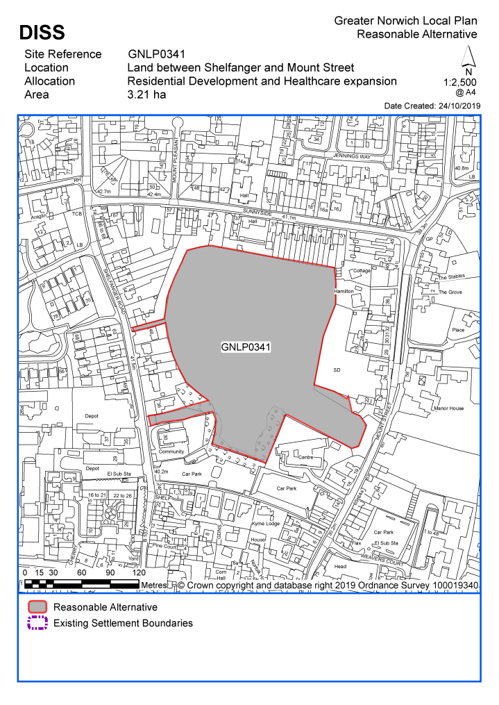
Land between Shelfanger Road and Mount Street |
GNLP0341 |
3.21 |
35 retirement living units, 5 detached dwellings and land set aside for future Health Centre expansion |
This site is considered to be a reasonable alternative if additional growth is needed in the towns, as it is centrally located with good access to services and facilities. It is not preferred for allocation at the current time as it is identified as an important open space in the South Norfolk Local Plan but as the proposed scheme suggests a small number of residential units and opening up and enhancing the currently inaccessible site for public access it is considered to be worthy of further consideration if further housing is needed in Diss. Any allocation would be subject to provision of acceptable visibility, which may require relocation of a utility pole. Overall, highways issues limit the scale of growth in Diss. |
| (6) | ||||
|
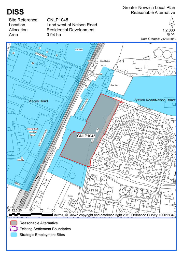
Land west of Nelson Road and east of Station Road |
GNLP1045 |
0.94 |
Residential (unspecified number) |
This site is within the existing settlement limit and is currently allocated for employment use under South Norfolk Local Plan policy DIS8. The promoter is now suggesting the site for residential use and due to its proximity to Diss railway station it is considered to be a reasonable alternative if it can be shown that the employment allocation is no longer required. There are potential amenity concerns from the railway and nearby industrial uses but there is also nearby residential development. Highway requirements would include a satisfactory vehicular access into the site, plus walking and cycling links to Diss railway station. Overall, highways issues limit the scale of growth in Diss. |
Unreasonable Sites - Residential
|
Address |
Site Reference |
Area (ha) |
Promoted for |
Reason considered to be unreasonable |
|
Diss (including part of Roydon) |
||||
| (1) | ||||
|
Land to the south of Prince William Way |
GNLP0185 |
1.01 |
Residential (unspecified number) |
This site is not considered to be suitable for allocation as it is already identified as part of existing allocation DIS1 in the South Norfolk Local Plan and as such is within the existing settlement limit. There are concerns that the estate road does not seem to extend to the site boundary and as such highway access does not seem to be available. |
|
|
||||
| (4) | ||||
|
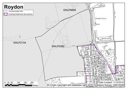
Land at Sturgeons Farm, off Farm Close, Louies Lane, Shelfanger Road |
GNLP0362 |
13.81 |
Residential use mixed led development of approx. 413 dwellings |
Although this site is adjacent to the existing settlement limit for Diss with safe pedestrian routes to schools in both Roydon and Diss it is considered to be an unsuitable site for allocation because residential development in this location would extend Diss further into the open countryside with consequential landscape impacts. |
|
|
||||
| (4) | ||||
|
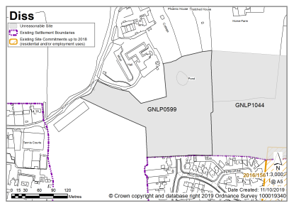
Land off Walcott Road, Walcott Green, Diss |
GNLP0599 |
3.29 |
Residential (unspecified number) |
This site is not considered to be suitable for allocation due to highways constraints. Residential development in this location would require road realignment and widening that does not appear achievable, along with provision of a footway at Walcot Road to the west. Development of this site would impact on the river valley and lead to an erosion of rural character. |
|
|
||||
| (4) | ||||
|
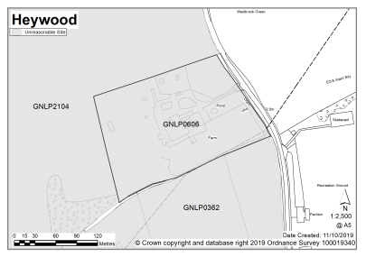
Boundary Farm, Shelfanger Road, Heywood |
GNLP0606 |
3.00 |
Residential (unspecified number) |
This site is not considered to be suitable for allocation as there is no safe walking route to schools in Diss and residential development in this location would extend the built-up area of Diss further into the open countryside with consequential landscape impacts. Nearly half the site is at risk of surface water flooding which would significantly affect the developable area. |
|
|
||||
| (4) | ||||
|
The Grange, Walcot Green, Diss |
GNLP1003 |
2.02 |
Residential (unspecified number) |
This site is not considered to be suitable for allocation as there is no safe walking route to local primary schools and no likelihood of being able to provide one. Residential development in this location would not be well related to the services and facilities in Diss and would extend the built-up area further into open countryside with consequential landscape impacts. |
|
|
||||
| (3) | ||||
|
Land north of Brewer Green Lane, Roydon |
GNLP1038 |
1.06 |
Residential development of approx. 8-12 dwellings |
This site is not considered to be suitable for allocation as it is separated from the existing settlement limit by Diss Town Football Club. Roads in the vicinity of the site are narrow and there is no safe walking route to schools in either Roydon or Diss. |
|
|
||||
| (5) | ||||
|
Land north of Frenze Hall Lane and west of Walcott Green, Diss |
GNLP1044 |
10.95 |
Residential (unspecified number) |
This site is not considered to be suitable for allocation due to highways constraints. Development would require Walcot Green to be widened to a minimum of 5.5 metres along with provision of a 2-metre wide footway between the access and Frenze Hall Road and this does not appear achievable due to land constraints at the southern end of the road. Residential development in this location would also extend the built-up area of Diss further into the open countryside with consequential landscape impacts. |
|
|
||||
| (5) | ||||
|
West of Shelfanger Road (part in Roydon, part in Heywood) |
GNLP2104 |
50.51 |
Residential development (unspecified number) |
This site is not considered to be suitable for allocation because if it was developed in its entirety it would be too large for the scale of development needed in Diss. Consideration was given to whether a smaller section towards the southern end of the site may be more acceptable but there are concerns about achieving satisfactory vehicular and pedestrian access. |
|
|
||||
Unreasonable Sites - Non-residential
|
Address |
Site Reference |
Area (Ha) |
Proposal |
Reason considered to be unreasonable
|
|
Diss |
||||
| (1) | ||||
|
Victoria Road, Diss |
GNLP2067 |
0.42 |
Repair and retail warehouse, business and offices |
The site is not preferred for allocation as it is subject to flood risk constraints and it is considered that there is already sufficient employment land allocated in Diss in the current South Norfolk Local Plan still to be developed. |
|
|
||||
Harleston is identified as a Main Town in the GNLP. The town is compact in form and sits on a plateau between Starston Beck to the north and the River Waveney to the south.
The town centre has many historic buildings and is based on a triangle of roads comprising The Thoroughfare, Broad Street, The Old Market Place and Exchange Street. The town has a good range of speciality shops and services, although the potential for expansion of the town centre is physically limited. Residential development has recently been completed on Mendham Lane, and there are proposals in place at both Fullers Place (planning application reference 2017/0099) and Spirketts Lane (carried forward allocation HAR4).
To the south of the town is the main employment area which benefits from good access to the A143. Whilst there has been some take up of the existing employment allocations, there remains a need to have land available for employment development to retain the balance of uses within the town (see carried forward allocations HAR6 and HAR7).
Existing sewerage infrastructure and surface water flooding are constraints in Harleston, including in the town centre. As a result, all allocated sites will need to show how they will address surface water drainage and sewerage infrastructure constraints to the satisfaction of Anglian Water, the Lead Local Flood Authority and the Environment Agency. A new water supply will be required to provide for the proposed level of growth in Harleston.
There are two sites identified as preferred options in Harleston providing for 450 new homes. The remaining commitment of 173 homes includes one carried forward residential allocation of 95 homes. This gives a total deliverable housing commitment for Harleston of 623 homes between 2018 – 2038.
All new and carried forward allocations are expected to address standard requirements associated with development. These vary from place to place but are likely to include mitigations for flood risk (as well as SUDs), highways improvements, safeguarding of minerals resources, land remediation, measures to protect the environment, biodiversity, and landscape intrusion.
|
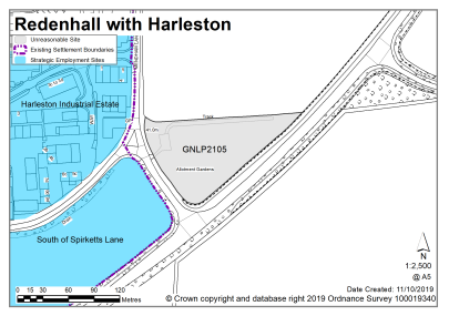
POLICY GNLP2108 Land South of Spirketts Lane, Harleston 7.10 ha is allocated for residential development. The site is likely to accommodate at least 150 homes, 33% of which will be affordable, and open space. More homes may be accommodated, subject to an acceptable design and layout being achieved and any infrastructure constraints addressed.
The development will be expected to address the following specific matters:
|
Notes
GNLP2108: This site is preferred for allocation as it is well located in terms of the form and character of Harleston. The site is in the designated river valley and this together with the relationship to the existing employment allocation to the east needs consideration. The allocation of the site is subject to provision of two satisfactory accesses, a frontage footway to connect with existing footways and revision of the speed limit. Consideration may need be given to improving the Shotford Road junction with London Road.
|
POLICY GNLP2136 Land at Briar Farm, Harleston 27.00 ha is allocated for mixed-use development. The site is likely to accommodate at least 300 homes, 33% of which will be affordable as well as care, employment, retail, open space and community facilities.
More homes may be accommodated, subject to an acceptable design and layout being achieved and any infrastructure constraints addressed.
The development will be expected to address the following specific matters:
|
Notes
GNLP2136: This site is preferred for allocation as it is well located in terms of the form and character of Harleston. The design of the development will need to overcome constraints including surface water flow path through the site, and the need for a sensitive approach to the river valley landscape. Development would require submission of a transport assessment and mitigation of any highway concerns.
Existing allocations to be carried forward
|
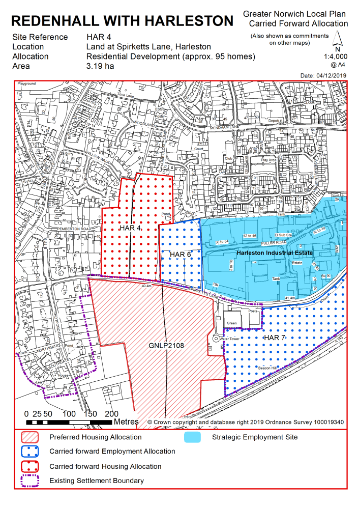
POLICY HAR 4 Land at Spirketts Lane, Harleston (approx. 3.19 ha) is allocated for residential development. This will accommodate approximately 95 homes. More homes may be accommodated, subject to an acceptable design and layout, as well as infrastructure constraints.
The development will be expected to address the following specific matters:
|
Notes
HAR 4: The site was allocated in 2015 as part of the current local plan but has not yet been developed. The principle of development is already accepted and it is expected that development will take place within the new local plan time-period. The site is considered in the calculation of the housing requirement, providing at least 95 homes, but more may be accommodated, subject to an acceptable design and layout, etc. being achieved.
|
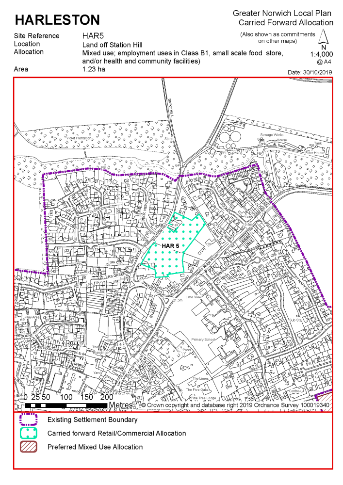
POLICY HAR 5 Land off Station Hill, Harleston (approx. 1.23 ha) is allocated for mixed use: employment uses in Class B1, a small-scale food store, and/or health and community facilities.
The development will be expected to address the following specific matters:
|
Notes
HAR 5: The site was allocated in 2015 as part of the current local plan but has not yet been developed. The principle of development is already accepted and it is expected that development will take place within the new local plan time-period. The site is re-allocated for employment/commercial development.
|
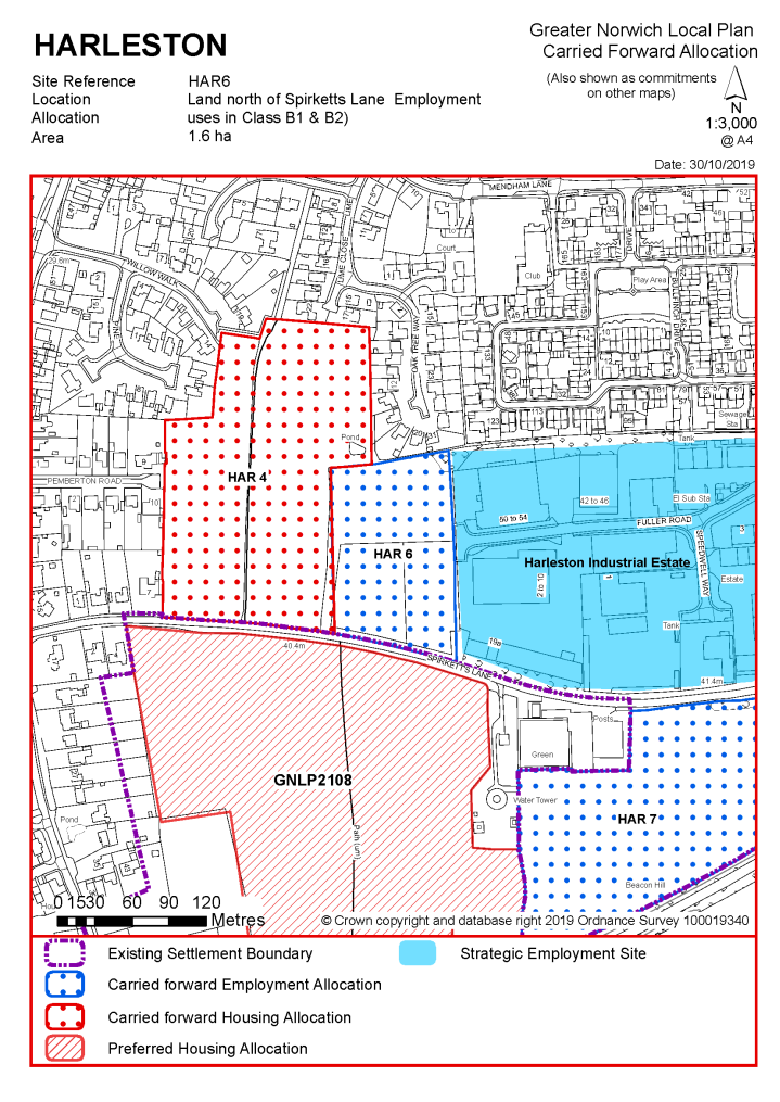
POLICY HAR 6 Land north of Spirketts Lane, Harleston (approx. 1.6 ha) is allocated for employment uses in Class B1/B2.
The development will be expected to address the following specific matters:
|
Notes
HAR 6: The site was allocated in 2015 as part of the current local plan but has not yet been developed. The principle of development is already accepted and it is expected that development will take place within the new local plan time-period. The site is re-allocated for employment/commercial development.
|
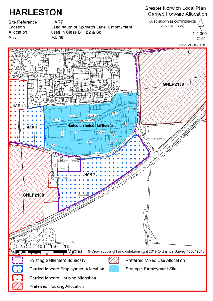
POLICY HAR 7 Land south of Spirketts Lane, Harleston (approx. 4 ha) is allocated for employment uses in class B1, B2 and B8.
The development will be expected to address the following specific matters:
|
Notes
HAR 7: The site was allocated in 2015 as part of the current local plan but has not yet been developed. The principle of development is already accepted and it is expected that development will take place within the new local plan time-period. The site is re-allocated for employment/commercial development. The site is a key gateway location into to the town but is remote from residential dwellings and is therefore considered more appropriate for B2 and B8 development. A high quality B1 business park could also work well in this location. Due to its gateway location by the A143 junction this site will need to be designed carefully to provide an appropriate and attractive entrance to Harleston. It will be important to encourage sustainable travel modes to and from the site.
|
Address |
Site Reference |
Area (ha) |
Proposal |
Reason for not allocating |
|
Redenhall with Harleston |
||||
|
NO REASONABLE ALTERNATIVE SITES
|
||||
Unreasonable Sites - Residential
|
Address |
Site Reference |
Area (ha) |
Promoted for |
Reason considered to be unreasonable |
|
Redenhall with Harleston |
||||
|
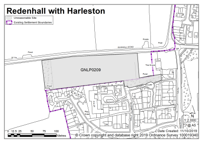
Land south of Rushall Road, Harleston |
GNLP0209 |
1.27 |
Approx. 40 dwellings |
This site is not preferred for allocation as it provides an attractive landscape approach to the town, with sensitive hedgerows and trees along the site boundary which form part of the roadside approach into Harleston. |
|
|
||||
|
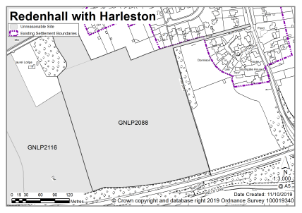
West of Shortford Road, Harleston |
GNLP2088 |
7.30 |
150 dwellings |
This site is not considered to be suitable for allocation as in highway terms it appears to be impossible to achieve an acceptable visibility splay within the highway or land promoted within the site boundary. The centre of the site has a significant area of surface water flood risk and avoiding this area would mean development would be located away from the existing built form, contrary to form and character. |
|
|
||||
|
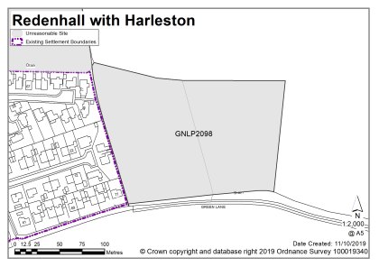
North of Green Lane, Harleston |
GNLP2098 |
2.52 |
65 dwellings |
Although there are safe pedestrian routes to Harleston Primary School from both Green Lane and Church View, the site is not considered to be appropriate for allocation as Jay's Green is not suitable for vehicular access. In addition, there is a band of surface water flood risk running across the site which would affect the developable area. |
|
|
||||
| (1) | ||||
|
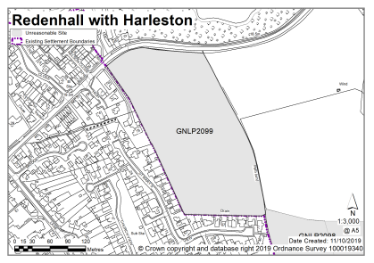
South of Redenhall Road, Harleston |
GNLP2099 |
4.40 |
110 dwellings |
This site is not considered suitable for allocation as there are concerns about the visual impact of developing an elevated site at the entrance to the town and the cost implications that this could have for the development. In highways terms development would probably require the realignment of Redenhall Road. |
|
|
||||
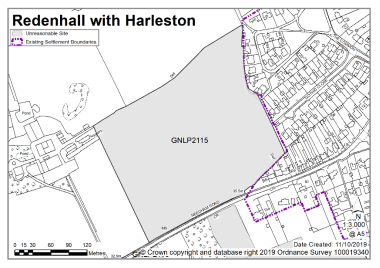
|
Mendham Lane, Harleston |
GNLP2105 |
1.00 |
20 dwellings |
This site is not considered to be suitable for allocation as residential development here would be disconnected from the rest of the town and out of keeping with form and character being a predominantly commercial area. The stretch of road between the A143 and start of the existing footpath on Mendham Lane is likely to be heavily used by commercial vehicles and so would not be a desirable route to be used by children to get to school. The site would be more acceptable if developed alongside site GNLP2136. |
|
|
||||
| (1) | ||||
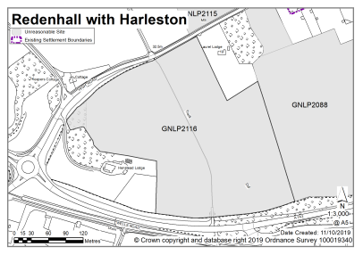
|
North of Needham Road, Needham
|
GNLP2115 |
6.00 |
175 dwellings |
This site is not preferred for allocation as it is wholly within the river valley and on grade 2 agricultural land. There is poor connectivity into Harleston and concern about possible coalescence of Needham and Harleston. If developed highway improvements would be required including two satisfactory access points. |
|
|
||||
|
South of Needham Road, Harleston (Technically in Needham Parish but considered with Harleston as well related to the built-up area) |
GNLP2116 |
7.00 |
160 dwellings |
This site is not preferred for allocation as although there is a pedestrian footway the site is some distance to Harleston Primary School. Development in this location would further extend the built-up area between Needham and Harleston. |
|
|
||||
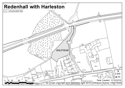
|
Land @ Church Lane, Redenhall |
GNLP3048 |
0.59 |
Residential (unspecified number) |
This site is not considered to be suitable for allocation as there is currently no settlement limit in this location and no justification to provide one as Redenhall has limited services and facilities. Although there is a footpath for much of the route into Harleston the site is some distance from the primary school and would involve pedestrians navigating the roundabout junction with the A143. |
|
|
||||
HETHEL (Strategic Employment Area)
Hethel is a small village within the parish of Bracon Ash and Hethel. It is predominately rural in character, comprising isolated housing and farm buildings. However, it is also a strategic employment location and is home to Lotus Cars and the Hethel Engineering Centre.
The settlement has a very limited range of services other than those provided by the existing businesses and consequently housing potential is limited. General employment is also not appropriate in this location. Instead the strategic objective is to reinforce the continued growth of advanced engineering and technology-based businesses in land-use terms.
Hethel has been home to the head office and factory of Lotus Cars since the 1960's. The Lotus factory is located on the former RAF Hethel airbase, with the test track using sections of the old runway. More recently the Hethel Engineering Centre has been developed in a prominent position on Wymondham Road, and a number of other employment uses have been developed immediately to the east. The Engineering Centre is dedicated to supporting the growth and success of high-performance engineering and manufacturing and offers business incubation space, specialist business support, engineering consultancy and conference/training facilities.
All new and carried forward allocations are expected to address standard requirements associated with development. These vary from place to place, but are likely to include mitigations for flood risk (as well as SUDs), highways improvements, safeguarding of minerals resources, land remediation, measures to protect the environment, biodiversity, and landscape intrusion.
|
POLICY GNLP2109 South of Hethel Industrial Estate, Bracon Ash (approx. 0.79 ha) is allocated for employment uses associated with, or ancillary to, advanced engineering and technology-based business.
Development of this site will be expected to address the following specific matters:
|
Notes
GNLP2109: The site is preferred for allocation, allowing capacity within the time period of the plan for the continued growth of employment uses associated with or ancillary to advanced engineering and technology-based businesses at Hethel.
Existing allocation to be carried forward
|
POLICY HETHEL 1 Restriction of employment uses at Hethel
New development within the defined development boundary at Hethel will only be permitted if it is associated with, or ancillary to, advanced engineering and technology-based businesses.
|
|
POLICY HETHEL 2 Land South and South West of Lotus Cars, Hethel (approx. 20 ha) is allocated for uses associated with, or ancillary to, advanced engineering and technology-based business.
The development will be expected to address the following specific matters:
|
Notes
HETHEL 2: The site was allocated in the previous Local Plan but has not yet been developed. The principle of development on the site has already been accepted and it is expected that development will take place within the time-period of this Local Plan. The site is re-allocated for employment/commercial development and will help to integrate the Hethel Engineering Centre with the existing developed area. Due to the size of the allocation a range of supporting infrastructure and facilities will be required, and the site should be masterplanned to maximise integration with existing businesses.
LONG STRATTON (including part of Tharston and Hapton parish)
Long Stratton is a large village which is set to grow into a small town, with Long Stratton having recently become a Town Council, and it is therefore identified as a Town in the GNLP. The settlement includes land that falls within the parish of Tharston and Hapton on its western edge. Current plans for Long Stratton, set out in Long Stratton Area Action Plan (May 2016), allocate a minimum of 1,800 new houses, 12 hectares of employment, an enhanced town centre and supporting infrastructure including a by-pass on the eastern side of the settlement.
Long Stratton has a good range of services and facilities that are mainly located along The Street (A140). On the western side of the town there are primary and secondary schools, a leisure centre, the district council offices, and Tharston Industrial Estate. The historic core of Long Stratton evolved north-south along the A140 but in recent decades estate development has been added away from this area. In terms of the landscape and environment, the Tas Valley is to the west and various designated common lands are to the east and south. In terms of new housing, the existing commitment of as yet unbuilt homes is 1,970 (April 2018). In 2016 a Neighbourhood Plan area for Long Stratton was agreed that covers the same area as Long Stratton Area Action Plan. The Neighbourhood Plan is currently being progressed.
There are no new sites identified as preferred options in Long Stratton. There are no carried forward allocations but a total of 1,892 additional dwellings with planning permission. This gives a total deliverable housing commitment for the Long Stratton & part of Tharston & Hapton of 1,892 homes between 2018 – 2038.
All new and carried forward allocations are expected to address standard requirements associated with development. These vary from place to place but are likely to include mitigations for flood risk (as well as SUDs), highways improvements, safeguarding of minerals resources, land remediation, measures to protect the environment, biodiversity, and landscape intrusion.
(1) No new allocations are proposed
Existing allocations to be carried forward
Notes:
The allocations identified in the Long Stratton Area Action Plan will not be superseded by the Greater Norwich Local Plan.
|
Address |
Site Reference |
Area (ha) |
Proposal |
Reason for not allocating |
|
Long Stratton, (including part of Tharston and Hapton parish) |
||||
|
NO REASONABLE ALTERNATIVE SITES
|
||||
Unreasonable Sites - Residential
|
Address |
Site Reference |
Area (ha) |
Promoted for |
Reason considered to be unreasonable |
|
Long Stratton, (including part of Tharston and Hapton parish) |
||||
|
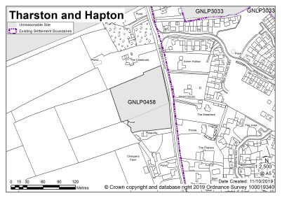
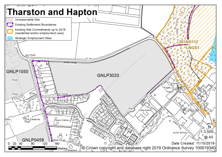
Land west of Chequers Road, Tharston and Hapton |
GNLP0142 |
1.74 |
Residential (unspecified number) |
This site is relatively accessible to services and facilities but is less well related to the built form of Long Stratton and affords less opportunity to deliver a safe walking route to school than other sites put forward. The site is not considered to be suitable for allocation as it extends some distance into open countryside, out of scale with the form of the settlement and residential development in this location would not be particularly compatible with adjoining existing and proposed commercial uses. The existing level of commitment in Long Stratton through the Area Action Plan is high, limiting the need for additional sites. |
|
|
||||
|
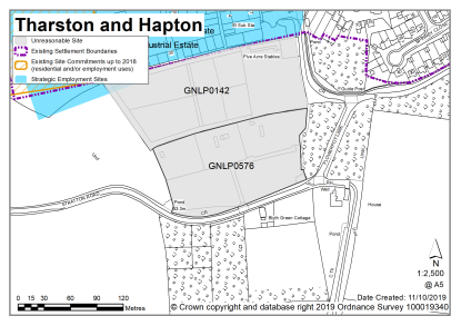
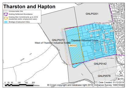
Land next to Tharston Industrial Estate, west of Chequers Lane, Tharston and Hapton |
GNLP0201 |
3.90 |
Mixed use (residential and industrial) |
This site is not considered to be suitable for allocation due to highway concerns over network capacity. The existing level of commitment in Long Stratton through the Area Action Plan is high, limiting the need for additional sites. |
|
|
||||
|
Land to the west of Chequers Road, Tharston and Hapton |
GNLP0458 |
0.96 |
Approx. 20 dwellings with open space |
This site is not considered to be suitable for allocation as it would require significant road infrastructure, junction and highways improvements and as well as new footways to deliver a safe walking route to school. The site is also subject to a high risk of surface water flooding across a large part of the site which may be difficult to mitigate. The existing level of commitment in Long Stratton through the Area Action Plan is high, limiting the need for additional sites. |
|
|
||||
| (1) | ||||
|
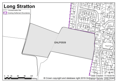
Land south of St Mary's Road, Long Stratton |
GNLP0509 |
3.60 |
60-100 dwellings with associated open space |
This site is not considered to be suitable for allocation as a planning refusal for 52 homes and open space was recently upheld at appeal. The existing level of commitment in Long Stratton through the Area Action Plan is high, limiting the need for additional sites. |
|
|
||||
|
Blyth Green Park, Stratton Road, Tharston and Hapton |
GNLP0576 |
1.45 |
Residential (unspecified number) |
This site is relatively accessible to services and facilities but less well related to the built form of Long Stratton and affords less opportunity to deliver a safe walking route to school than other sites put forward. Residential development would not be particularly compatible with adjoining existing and proposed commercial uses and therefore the site is not considered to be suitable for allocation. The existing level of commitment in Long Stratton through the Area Action Plan is high, limiting the need for additional sites. |
|
|
||||
|
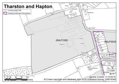
Land at Ciudad Rodrigo Farm, Forncett Road, Tharston and Hapton |
GNLP1050 |
7.50 |
Housing with associated access and open space, ranging from 35-100 homes |
This site is not considered to be suitable for allocation as residential development in this location would be a major intrusion into the rural gap with landscape and ecological impacts. The site would require significant road infrastructure, junction and highways improvements as well as new footways to deliver a safe walking route to school. The existing level of commitment in Long Stratton through the Area Action Plan is high, limiting the need for additional sites. |
|
|
||||
|
South of Swan Lane, Tharston and Hapton |
GNLP3033 |
5.28 |
80 dwellings plus 40 bed care homes |
Despite being highly accessible to schools, the council offices and a range of other services and facilities this site is not considered to be suitable for allocation due to highway issues as there are concerns over the network capacity of the A140 and Swan Lane junction. The existing level of commitment in Long Stratton through the Area Action Plan is high, limiting the need for additional sites. |
|
|
||||
Wymondham is classified as a main town in the emerging local plan and is the largest settlement in South Norfolk. The town has a wide range of services and facilities, including primary and secondary schools, leisure centre, library, extensive outdoor recreation facilities, as well as commercial and employment opportunities. Wymondham is strategically well placed for development, being on the Cambridge/Norwich Tech Corridor, which follows the route of the A11 and the Norwich/Cambridge rail line. However, only a relatively small level of new growth is proposed in Wymondham due to the scale of the existing commitment.
The town has a long and rich history. The Abbey was founded in 1107, and the 17th Century Market Cross remains the focal point of the town. Within the town itself there are over 200 listed buildings and the quality of the built environment helps support the continued success of retail and business activity in Wymondham. Wymondham continued to grow during the 20th century, particularly with development to the north, as shown by various residential areas accessed from the B1135 Tutttles Lane West. During the 1990s and 21st century, development continued: north-east of Tuttles Lane East (either side of Norwich Road towards Hethersett); east of Harts Farm Road off the B1172; and, at the south of the town, east of Silfield Road. Recent allocations in the Wymondham Area Action Plan (WAAP - October 2015) have focussed on rebalancing development to the south of the town, between the Norwich/Cambridge rail line and the A11 bypass, and around the station.
On the edge of town, the Gateway 11 Business Park is well-established, and the town also has good access to high quality employment opportunities at Norwich Research Park and Lotus/Hethel Engineering Centre. Additional employment allocations were made in the WAAP, predominantly either side of Browick Road. To the west of the town the River Tiffey Valley remains a largely intact rural landscape. Likewise, to the south-west, undeveloped views remain of the Abbey from a considerable distance. Despite considerable development pressure in the A11 corridor, planning policies have helped protect the separate identities of Wymondham and the nearby settlements of Hethersett and Spooner Row. The new allocations in this plan should be read in the context of the extant Wymondham Area Action Plan (or any successor document).
There are two sites identified as preferred options in Wymondham providing for 100 new homes. In addition, there is a contingency for 1000 new homes to be provided on currently unspecified sites, should they be required to support the delivery of housing in the plan. There are no carried forward allocations but a total of 2463 additional dwellings with planning permission. This gives a total deliverable housing commitment for Wymondham of 2,563 to 3,563 homes between 2018 – 2038.
All new and carried forward allocations are expected to address standard requirements associated with development. These vary from place to place, but are likely to include mitigations for flood risk (as well as SUDs), highways improvements, safeguarding of minerals resources, land remediation, measures to protect the environment, biodiversity, and landscape intrusion.
|
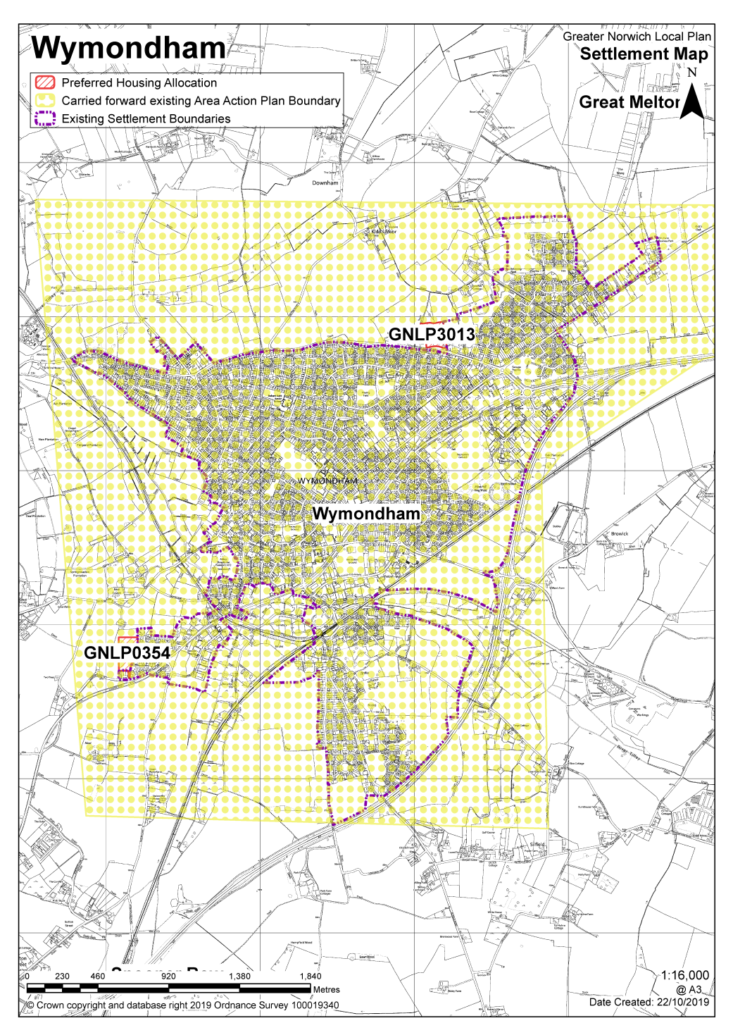
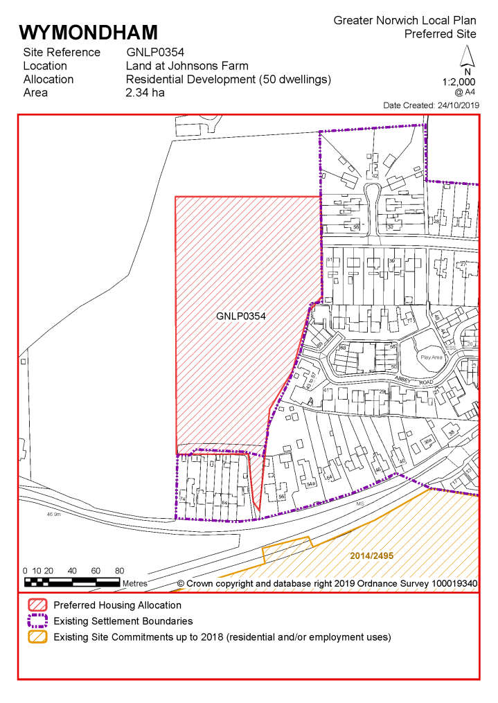
POLICY GNLP0354 Land at Johnson's Farm, Wymondham (approx. 2.34 ha) is allocated for residential development. The site is likely to accommodate at least 50 homes, 33% of which will be affordable. More homes may be accommodated, subject to an acceptable design and layout being achieved.
The development will be expected to address the following specific matters:
|
Notes
GNLP0354 (part): This smaller area of the larger site proposal is considered to be suitable for allocation because development here would not adversely impact on views of Wymondham Abbey and it was previously considered as appropriate in early drafts of the Wymondham Area Action Plan. The majority of the site is considered to be unreasonable due to the impact on the setting of Wymondham Abbey and associated landscape. The allocation must be accessed via Abbey Road or Preston Avenue.
|
POLICY GNLP3013 Land North of Tuttles Lane, Wymondham (approx. 2.31 ha) is allocated for residential development. The site is likely to accommodate at least 50 homes, 33% of which will be affordable. More homes may be accommodated, subject to an acceptable design and layout being achieved.
The development will be expected to address the following specific matters:
|
Notes
GNLP3013: This site is considered to be suitable for allocation because it relates well to the existing form and character of Wymondham and has minimal constraints. The allocation is subject to acceptable access and provision of a footway to link up with existing footways. Although not technically brownfield the site has a previously developed character having been used for caravan storage for a number of years.
Existing allocations to be carried forward
Notes
Allocations identified in the Wymondham Area Action Plan will not be superseded by the new local plan.
|
Address |
Site Reference |
Area (ha) |
Proposal |
Reason for not allocating |
|
Wymondham |
||||
| (4) | ||||
|
Land to the north of Tuttles Lane East |
GNLP0006 |
53.68 |
Residential (unspecified number), public open space, community use and primary school |
This site is considered to be a reasonable alternative if additional growth is needed in the towns. The plan includes a 1000 dwelling contingency at Wymondham on unspecified sites. It is well located in terms of schools, public transport and retail opportunities, although more distant from the town centre. This site could be considered as part of a comprehensive extension to the north of Wymondham with associated infrastructure improvements. The site has relatively few constraints but there would be some landscape impacts from breaking the current northern boundary of the settlement. |
| (6) | ||||
|
Land at south Wymondham – north and south of the A11 and west of Park Lane |
GNLP0515 |
132.22 |
1500 dwellings, community uses, open space, landscaping and associated infrastructure |
This site is considered to be a reasonable alternative if additional growth is needed in the towns. The plan includes a 1000 dwelling contingency at Wymondham on unspecified sites. Development of this site may have landscape/townscape issues and highway concerns which would need to be addressed prior to allocation. (This site also forms part of the Silfield Garden Village proposal with sites GNLP0403 and GNLP2168. This combination of sites is considered to be a reasonable alternative for consideration as a new settlement through a future review of the plan. The site is not preferred for allocation as it is not proposed to include a new settlement in the Greater Norwich Local Plan at the current time). |
| (8) | ||||
|
North Wymondham |
GNLP0525R |
157.00 |
Mixed. Up to 1500 dwellings, school, employment, recreation etc |
This site is considered to be a reasonable alternative if additional growth is needed in the towns. The plan includes a 1000 dwelling contingency at Wymondham. It is well located in terms of schools, public transport and retail opportunities, although more distant from the town centre. This site could be considered as part of a comprehensive extension to the north of Wymondham with associated infrastructure improvements. The site has relatively few constraints but there would be some landscape impacts from breaking the current northern boundary of the settlement. |
| (5) | ||||
|
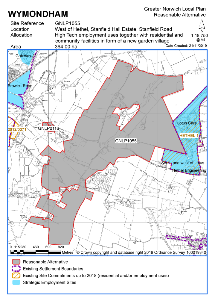
West of Hethel, Stanfield Hall Estate, Stanfield Road |
GNLP1055 |
364.00 |
High Tech employment uses together with residential and community facilities in form of a new garden village |
This site is promoted as a new garden village. It is considered to be a reasonable alternative for consideration as a new settlement through a future review of the plan. The site is not preferred for allocation as it is not proposed to include a new settlement in the Greater Norwich Local Plan at the current time. |
| (3) | ||||
|
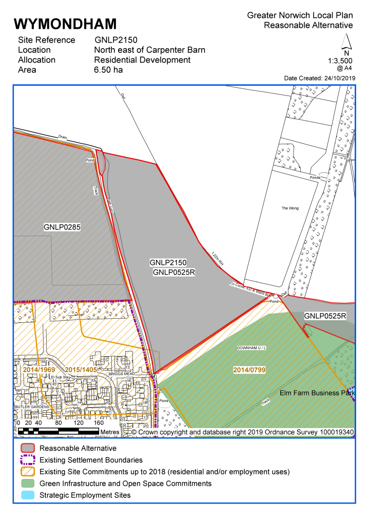
North east of Carpenter Barn |
GNLP2150 |
6.50 |
150 dwellings |
This site considered to be a reasonable alternative if additional growth is needed in the towns. The plan includes a 1000 dwellings contingency at Wymondham on unspecified sites. It is well located in terms of schools, public transport and retail opportunities. This site could be part of a comprehensive extension to the north of Wymondham with associated infrastructure improvements. A planning application for 150 dwellings is currently under consideration (2019/0184). |
| (2) | ||||
|
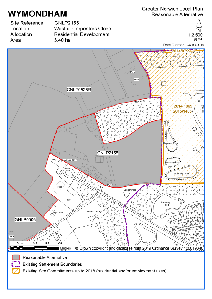
West of Carpenter Close |
GNLP2155 |
3.40 |
80 dwellings |
This site is considered to be a reasonable alternative if additional growth is needed in the towns. The plan includes a 1000 dwelling contingency at Wymondham on unspecified sites. It is well located in terms of schools, public transport and retail opportunities. This site could be part of a comprehensive extension to the north of Wymondham with associated infrastructure improvements. |
| (6) | ||||
|
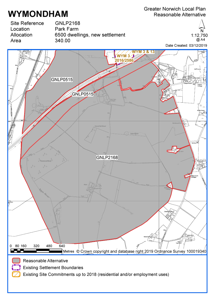
Park Farm |
GNLP2168 |
340.00 |
6500 dwellings, new settlement |
This site is promoted as Silfield Garden Village (with sites GNLP0403 and GNLP0515). This combination of sites is considered to be a reasonable alternative for consideration as a new settlement through a future review of the plan. The site is not preferred for allocation as it is not proposed to include a new settlement in the Greater Norwich Local Plan at the current time. |
Unreasonable Sites - Residential
|
Address |
Site Reference |
Area (ha) |
Promoted for |
Reason considered to be unreasonable |
|
Wymondham |
||||
|
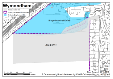
Land to the west of Silfield Road |
GNLP0032 |
6.17 |
Residential (unspecified number) |
This site is not considered to be suitable for allocation due to highway constraints. Wider access is somewhat limited as it would be via Silfield Road, which relies on a narrow section of highway under the railway bridge. There is already pressure on Silfield Road with the current South Wymondham housing allocation that is being built. The entrance into the site, at the top of Park Lane, is also constrained and not suitable for the scale of development proposed. |
|
|
||||
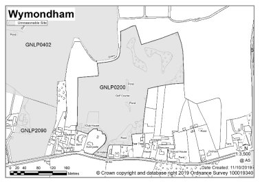
|
Silfield Pitch and Putt, The Street |
GNLP0200 |
5.97 |
Residential (unspecified number) |
This site is not considered to be suitable for allocation as it is remote from Wymondham, separated from services and facilities by the A11. |
|
|
||||
| (3) | ||||
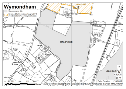
|
Land south of Gonville Hall Farm, West of Suton Lane, east of London Road and north of Sawyers Lane |
GNLP0320 |
36.90 |
500 dwellings |
This site is not considered to be suitable for allocation as it lies to the south of Gonville Hall at some distance from the existing built up area of Wymondham, separated by a permission which has not yet been delivered, and so would not form contiguous development. |
|
|
||||
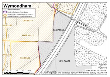
| (1) | ||||
|
Land at Rightup Lane, Silfield |
GNLP0355 |
1.34 |
Residential (unspecified number) |
This site is not considered to be suitable for allocation. As well as being remote from the town, and subject to possible noise from the A11, there are highway constraints. Access from Rightup Lane is unlikely to be possible so the site would need to be accessed through the adjacent allocation (WYM 3) which is already being built out. |
|
|
||||
| (2) | ||||
|
Land to the north east of Silfield Road and south of the A11 |
GNLP0402 |
26.87 |
800 dwellings, infrastructure, community uses and open space |
This site is not considered to be suitable for allocation as it is remote from Wymondham, separated from services and facilities by the A11. |
|
|
||||
| (2) | ||||
|
Land to the south west of Silfield Road and south of the A11 |
GNLP0403 |
13.30 |
400 dwellings, infrastructure, community uses and open space |
When considered on its own this site is not preferred for allocation as it is remote from Wymondham, separated from services and facilities by the A11. However, this site also forms part of the Silfield Garden Village proposal with site GNLP0515 and GNLP2168. It is not proposed to include a new settlement in the Greater Norwich Local Plan at the current time, but this could be considered through a future review of the plan. |
|
|
||||
|
Land north and south of Browick Road |
GNLP0507 |
21.85 |
Mixed commercial and residential |
This site is considered to be unreasonable to allocate for residential development as it is currently allocated for employment use in the Wymondham Area Action Plan and this is considered to be a prime location for commercial development on the A11. |
|
|
||||
|
Burnthouse Lane, Silfield |
GNLP2073 |
0.65 |
5 dwellings |
This site is not considered to be suitable for allocation as it is remote from Wymondham, poorly related to services and facilities. |
|
|
||||
|
East of Field House |
GNLP2090 |
1.70 |
50 dwelling |
This site is not considered to be suitable for allocation as it is remote from Wymondham, separated from services and facilities by the A11. |
|
|
||||
|
Within WYM3 and WYM13 allocation |
GNLP2169 |
1.36 |
32 dwellings |
This site is within the WYM 3 allocation from the Wymondham Area Action Plan where the principle of housing has already been accepted. Development should come forward as part of a comprehensive scheme in accordance with the existing allocation rather than being planned separately. |
|
|
||||
|
Unreasonable Sites - Non-Residential
|
||||
|
Address |
Site Reference |
Area (Ha) |
Proposal |
Reason considered to be unreasonable
|
|
Wymondham |
||||
|
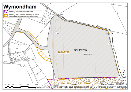
Land north of Carpenters Barn, Wymondham |
GNLP0285 |
15.38 |
Recreational Use |
This site is not preferred for allocation as consent has already been granted under planning application reference 2014/0799 for a clubhouse with sports pitches. |
|
|
||||
| (1) | ||||
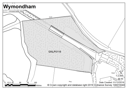
|
Stanfield Road, Wymondham |
GNLP0116 |
2.99 |
Employment |
This proposal appears to be for the expansion of operations at the Goff Petroleum Fuel Depot as per expired planning permission 2010/2232 for offices, workshops, warehousing and distribution. Due to the specific nature of these proposals and the depot's location some distance from the built-up area of Wymondham this site is not considered to be suitable for allocation and would be better dealt with through the planning application process. |
|
|
||||