Draft Local Plan-Part 2 Site Allocations
VILLAGE CLUSTERS BROADLAND
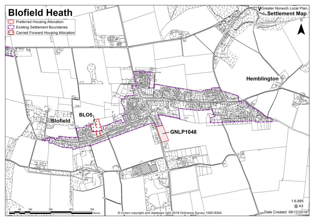
BLOFIELD HEATH AND HEMBLINGTON
Schedule of Corrections - This schedule will be added to if further corrections are required through the consultation process.
The catchment of Hemblington Primary School brings Blofield Heath and Hemblington into a village cluster. The school has spare capacity and is not landlocked.
It is considered that due to the high levels of existing commitment in Blofield parish as a whole approximately 12-20 new homes are appropriate for the Blofield Heath cluster. Services in the wider parish of Blofield include primary school, village hall, food shop, public transport and a doctor's surgery.
Blofield Heath is covered by the made Blofield Neighbourhood Plan which covers the same area as that of the Blofield parish boundary. The Plan was made in July 2016 and covers the period to 2036. It contains a series of policies that look to shape development within the neighbourhood area. There are policies within the plan that will be of relevance to development and any applications that are submitted for development within the parish should have due regard to those policies.
The figure of 353 quoted in the strategy refers to Blofield parish as a whole including Blofield Heath (but not Hemblington). In the settlement chapters, Blofield sites located south of the A47 have been counted in Blofield Key Service Centre; sites located north of the A47 have been counted as Blofield Heath and Hemblington village cluster. The distribution of figures between the two areas in the settlement chapters is shown in the tables below. For clarity, the figures highlighted in blue in 'Blofield Heath and Hemblington' have been counted in 'Blofield' in the strategy. This approach may be amended in the Regulation 19 version of the GNLP, comments are welcomed.
|
Blofield Heath & Hemblington |
Village Cluster |
|
New allocations |
15-20 |
|
Carried forward allocations |
36 (BLO5) |
|
PPs on other sites |
Blofield Heath: 9+8+4+1+1+1+3+1=28 Hemblington = 7 Total = 28+7=35 |
|
Total commitment (carried forward + pp) |
35+36=71 |
|
Overall Total (New and commitment) |
86-91 |
|
Blofield |
Key Service Centre |
|
New allocations |
15 |
|
Carried forward allocations |
163 (BLO1) |
|
PPs on other sites |
7+4+1+1+6+21+20+1+8+9+21+10+2=111 |
|
Total commitment (carried forward + pp) |
163+111=274 |
|
Overall Total (New and commitment) |
274+15=289 |
|
STRATEGY |
289 +28 + 36 = 353 |
In Blofield Heath and Hemblington, one site is identified as a preferred option, providing for between 15-20 new homes in the cluster. There is one carried forward allocation for 36 homes (BLO5) and a total of 35 additional dwellings with planning permission on small sites. This gives a total deliverable housing commitment for the cluster of between 86 – 91 homes between 2018 – 2038.
All new and carried forward allocations are expected to address standard requirements associated with development. These vary from place to place, but are likely to include mitigations for flood risk (as well as SUDs), highways improvements, safeguarding of minerals resources, land remediation, measures to protect the environment, biodiversity, and landscape intrusion.
|
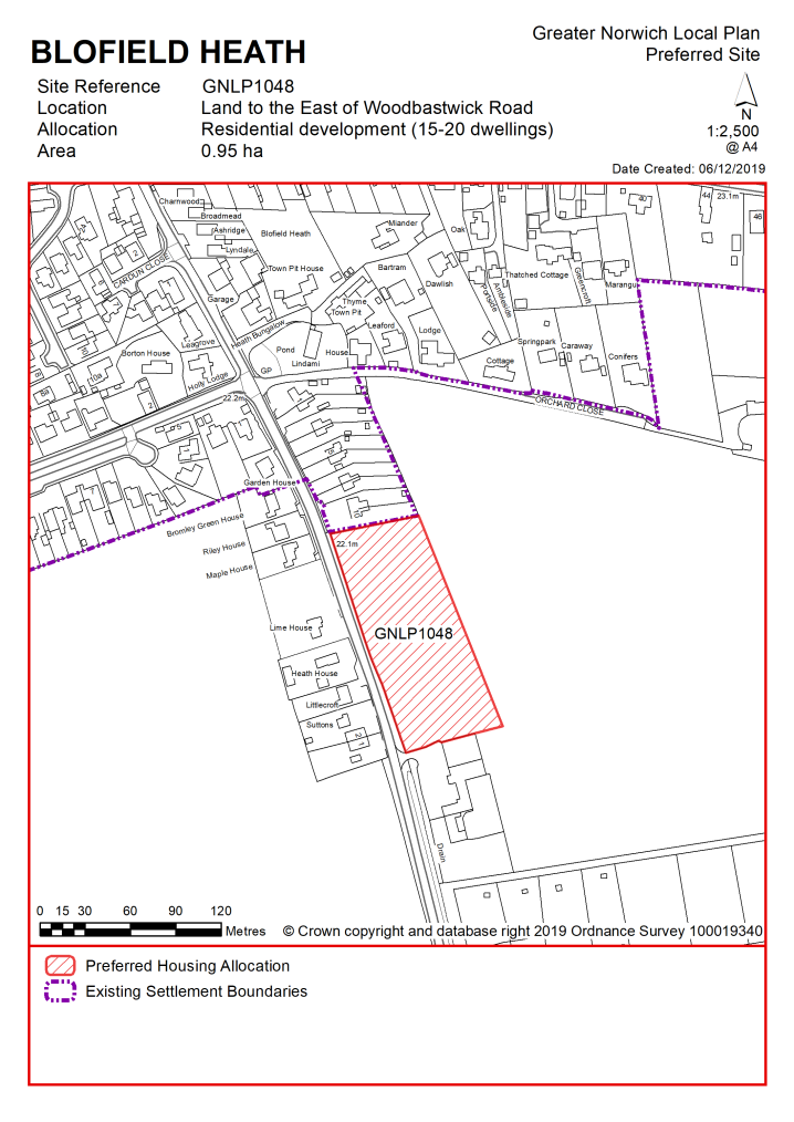
POLICY GNLP1048 – Land east of Woodbastwick Road, Blofield Heath (approx. 0.95ha) is allocated for residential development. The site is likely to accommodate 15-20 homes, 33% of which will be affordable. More homes may be accommodated, subject to an acceptable design and layout, as well as infrastructure constraints. The development will be expected to address the following specific matters:
|
Notes
GNLP1048: Part of this site is preferred for allocation as it is well related to the form and character of the settlement with safe pedestrian access to Hemblington Primary School and minimal other constraints. The site is allocated subject to vehicular access at Woodbastwick Road, provision of a frontage footway, improvement to existing footway at Mill Road and provision of a pedestrian crossing point at the Mill Road/Woodbastwick Road junction.
Existing allocation carried forward
|
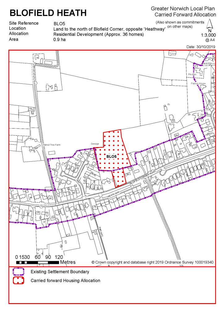
POLICY BLO5 - Land to the north of Blofield Corner, opposite 'Heathway', Blofield Heath (approx. 0.9ha) is allocated for residential development. This will accommodate approximately 36 homes.
The development will be expected to address the following specific matters:
|
Notes
BLO5: This site was allocated in 2016 as part of the current local plan but has not yet been developed. The principle of development on the site has already been accepted and it is expected that development will take place within the new local plan time-period up to 2038. The site is considered in the calculation of the housing requirement, providing at least 36 homes reflecting planning permission given on the site (20140968 and 20162199).
|
Address |
Site Reference |
Area (ha) |
Promoted for |
Comments |
|
Blofield Heath and Hemblington |
||||
Unreasonable Sites – Residential
|
Address |
Site Reference |
Area (ha) |
Promoted for |
Reason considered to be unreasonable |
|
Blofield Heath |
||||
|
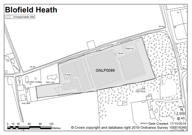
Blofield Nurseries, Hall Road |
GNLP0099 |
2.85 |
Up to 25 dwellings |
This site is considered to be unreasonable for allocation as it is located some way beyond the built edge of the village with no safe pedestrian route to Hemblington Primary School. Development of this site would not be well related to the form and character of the settlement. |
|
|
||||
|
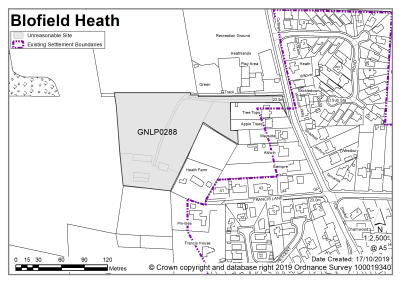
Land to the west of Woodbastwick Road |
GNLP0288 |
1.43 |
24 dwellings |
This site is considered to be unreasonable for allocation as the planning history suggests there are access constraints which means that the site would only be suitable for small scale development off a private drive. It therefore would not be able to accommodate the minimum allocation size of 12-15 dwellings. |
|
|
||||
|
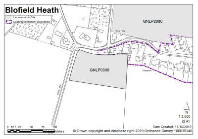
Land east of Park Lane |
GNLP0300 |
0.78 |
Residential (unspecified number) |
Although this site is adjacent to the existing settlement limit it is considered to be unreasonable for allocation as there is no continuous footway to Hemblington Primary School. There is a better located site to meet the capacity of the cluster. |
|
|
||||
| (2) | ||||
|
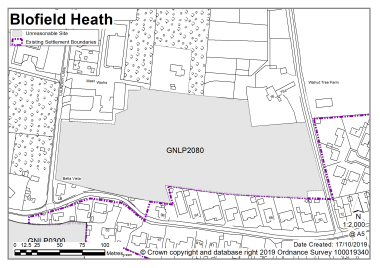
Dawson's Lane |
GNLP2080 |
2.65 |
42 dwellings |
Although this site is adjacent to the existing settlement limit it is considered to be unreasonable for allocation as there is no continuous footway to Hemblington Primary School. There is a better located site to meet the capacity of the cluster. In addition, the proposed access to the site is currently a narrow track with an unmade surface which would need upgrading to be acceptable. |
|
|
||||
|
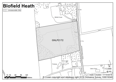
South of Blofield House |
GNLP2172 |
3.90 |
85 dwellings |
This site is located some way beyond the built edge of the village with no safe pedestrian route to Hemblington Primary School. Development of this site would not be well related to the form and character of the settlement. |
|
|
||||
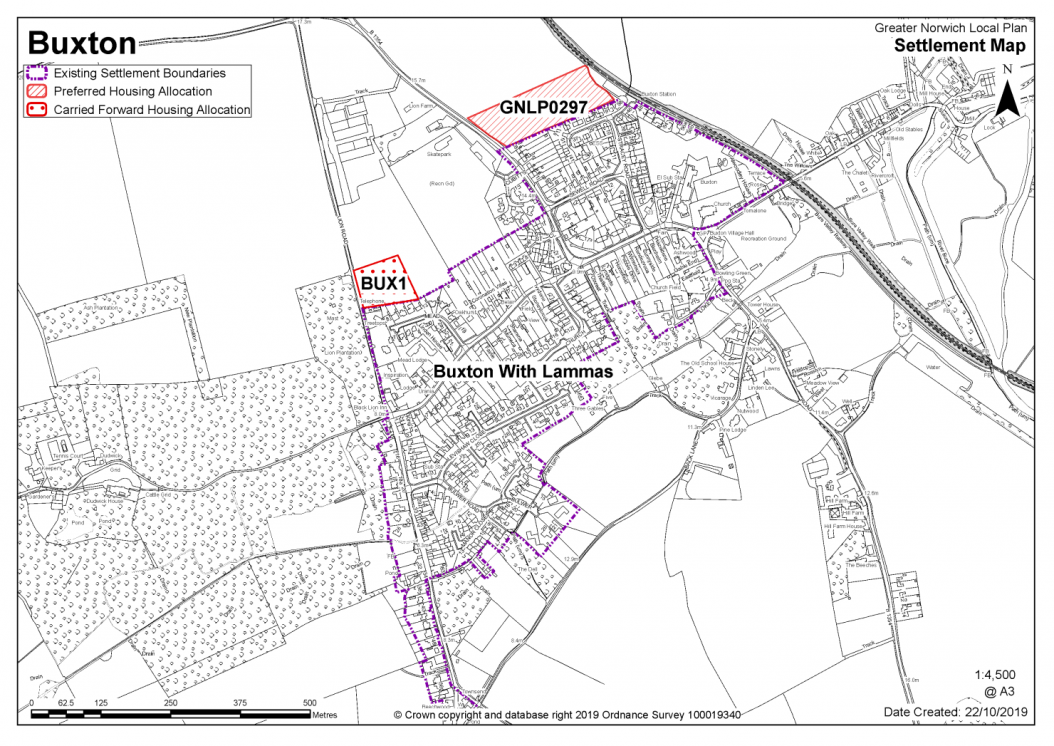
BUXTON WITH LAMAS AND BRAMPTON
The catchment of Buxton with Lamas Primary School brings Buxton with Lamas and Brampton into a village cluster. The school is currently close to capacity and is landlocked so there is limited scope for expansion. It is considered that as well as existing allocations and windfall development, approximately 40 homes is appropriate for the cluster. As well as a school, the cluster has a range of services that includes a village hall, shop and pub.
Buxton with Lamas has a neighbourhood area designated and the parish council is working on an emerging Neighbourhood Plan (at time of writing). Any applications that are submitted for development within the parish should consider the emerging neighbourhood Plan for the area, in line with paragraph 48 of the National Planning Policy Framework').
One site is identified as a preferred option, providing for between 30-40 new homes in the cluster. There is one carried forward residential allocation for 20 homes and a total of 5 additional dwellings with planning permission on small sites. This gives a total deliverable housing commitment for the cluster of between 55-65 homes between 2018-2038.
All new and carried forward allocations are expected to address standard requirements associated with development. These vary from place to place, but are likely to include mitigations for flood risk (as well as SUDs), highways improvements, safeguarding of minerals resources, land remediation, measures to protect the environment, biodiversity, and landscape intrusion.
|
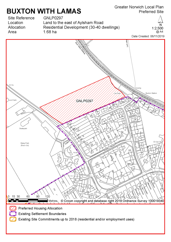
POLICY GNLP0297 – Land east of Aylsham Road, Buxton with Lamas (1.68ha) is allocated for residential development. The site is likely to accommodate 30- 40 homes, 33% of which will be affordable. More homes may be accommodated, subject to an acceptable design and layout, as well as infrastructure constraints.
The development will be expected to address the following specific matters:
|
Notes
GNLP0297: This is the only site considered suitable for allocation in Buxton. It is within an accessible walking/cycling distance of facilities such as Buxton Primary School although a short section of footway will need to be provided at the north east side of Aylsham Road to ensure a continuous safe route to school. Visibility to the north east could be challenging and it is likely that the speed limit will need to be extended.
Existing allocation carried forward
|
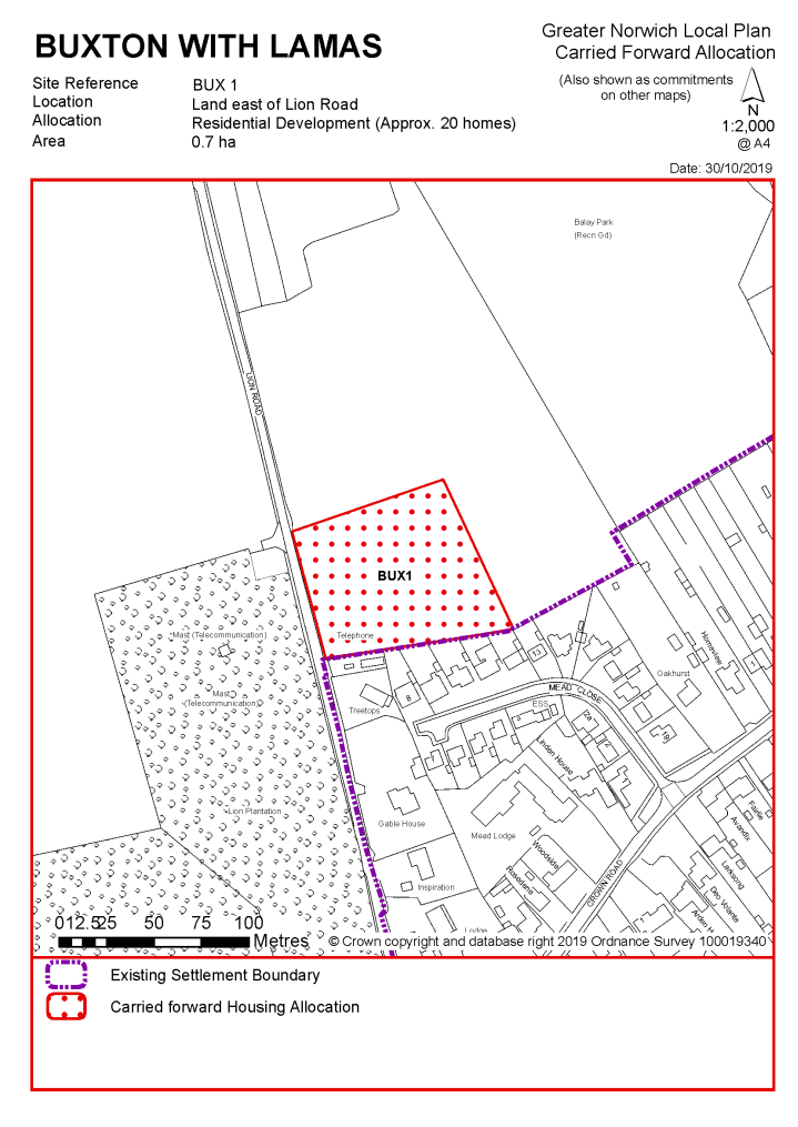
POLICY BUX1 Land east of Lion Road, Buxton (approx. 0.7ha) is allocated for residential development. This will accommodate approximately 20 homes.
The development will be expected to address the following specific matters:
|
Notes
BUX1: This site was allocated in the 2016 local plan but has not yet been developed. The principle of development on the site has already been accepted and it is expected that development will take place within the time-period of this local plan up to 2038. The site is considered in the calculation of the housing requirement, providing at least 20 homes, but more may be accommodated, subject to an acceptable design and layout being achieved.
|
Address |
Site Reference |
Area (ha) |
Promoted for |
Comments |
|
Buxton with Lamas and Brampton |
||||
|
NO REASONABLE ALTERNATIVE SITES |
||||
Unreasonable Sites - Residential
|
Address |
Site Reference |
Area (ha) |
Promoted for |
Reason considered to be unreasonable |
|
Buxton with Lamas and Brampton |
||||
| (3) | ||||
|
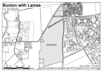
Land off Scottow Road |
GNLP0294 |
23.68 |
720 dwellings |
This site is too large for the capacity of the cluster. It is not well related to Buxton, being closer to Scottow which is in North Norfolk. North Norfolk District Council have said there is no intention to seek large scale growth in Scottow so the site is considered to be unreasonable for allocation. |
|
|
||||
| (2) | ||||
|
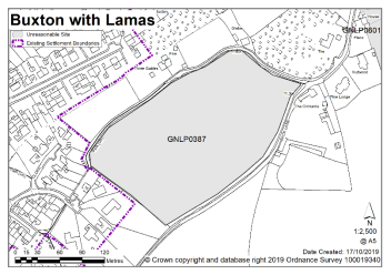
Land at Back Lane |
GNLP0387 |
3.62 |
Approx. 110 dwellings |
This site is considered to be unreasonable for allocation as Back Lane is a narrow single-track road with limited scope for improvement. The site is located to the south of the built edge of the village with no safe pedestrian route to Buxton Primary School. |
|
|
||||
| (2) | ||||
|
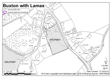
Land West of Coltishall Road |
GNLP0601 |
0.57 |
Extension to settlement limit for potential housing |
This site is considered to be unreasonable for allocation as it is located to the south of the built edge of the village, detached from the existing settlement limit. There is no safe pedestrian route to Buxton Primary School, and due to the narrowness of the verge on both sides of Coltishall Road the necessary footway improvements would be difficult to achieve. |
|
|
||||
|
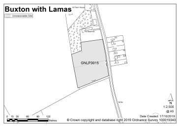
South of the Beeches, Coltishall Road |
GNLP3015 |
1.06 |
Up to 30 dwellings |
This site is located to the south of the existing built edge of the village, some way from the existing settlement limit. It is considered to be unreasonable for allocation as development here would not be well related to the form and character of the settlement and there is no safe pedestrian route to Buxton Primary School. Approximately 600m of footway would be needed to link with the existing which is unlikely to be feasible or viable. |
|
|
||||
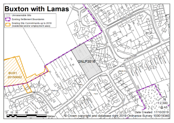
| (1) | ||||
|
Feofee Cottages, North of Crown Road |
GNLP3016 |
0.47 |
Affordable rented housing up to 20 properties |
This site is centrally located within the settlement limit and could be progressed now as a planning application to deliver the affordable rented housing proposed rather than waiting for the Local Plan process. |
|
|
||||
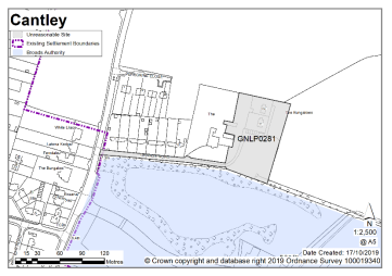
Cantley is not clustered with other settlements, as the school catchment does not extend to adjoining villages. There is capacity at the school, although the site is landlocked. Services include a primary school, village hall and 'journey to work' public transport service.
Whilst it is considered the cluster could accommodate development of 50-60 additional homes, there are currently no new allocations proposed and no allocations to be carried forward in this cluster. There are however 5 dwellings with planning permission on small sites. No new allocations are proposed but further development is not ruled out. Windfall development policy 7.4 allows an amount of growth in each village cluster that reflects primary school capacity. See settlement map for the extent of existing settlement limits.
No existing allocations to be carried forward.
|
Address |
Site Reference |
Area (ha) |
Promoted for |
Comments |
|
Cantley |
||||
|
NO REASONABLE ALTERNATIVE SITES |
||||
Unreasonable Sites - Residential
CAWSTON, BRANDISTON AND SWANNINGTON
The catchment of Cawston Primary School brings Cawston, Brandiston and Swannington into a village cluster. The school is currently very close to capacity, although it is not landlocked and could be extended.
It is considered that as well as existing allocations and windfall development, approximately 40 new homes are appropriate for the Cawston cluster to in order to ensure that the setting of the village is preserved. Cawston has a range of facilities including a primary school, village hall, food shop, pub, petrol station, public transport, some local employment and a GP. Brandiston and Swannington have a limited range of services.
Consequently, one site is identified as a preferred option, providing for between 30-40 new homes in the cluster. There is one carried forward residential allocation for 20 homes and a total of 16 additional dwellings with planning permission on small sites. This gives a total deliverable housing commitment for the cluster of between 66 – 76 homes between 2018 – 2038.
All new and carried forward allocations are expected to address standard requirements associated with development. These vary from place to place, but are likely to include mitigations for flood risk (as well as SUDs), highways improvements, safeguarding of minerals resources, land remediation, measures to protect the environment, biodiversity, and landscape intrusion.
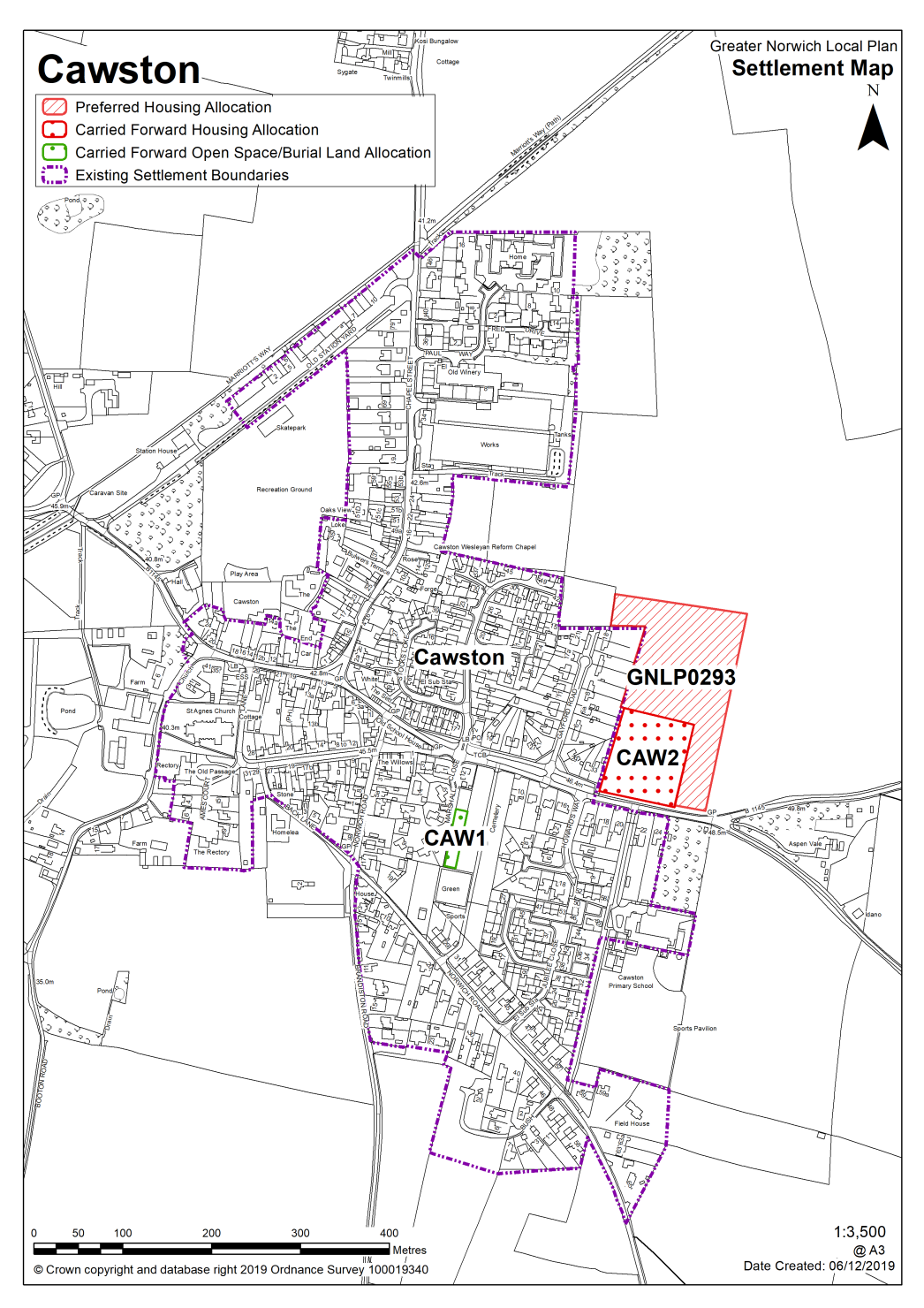
|
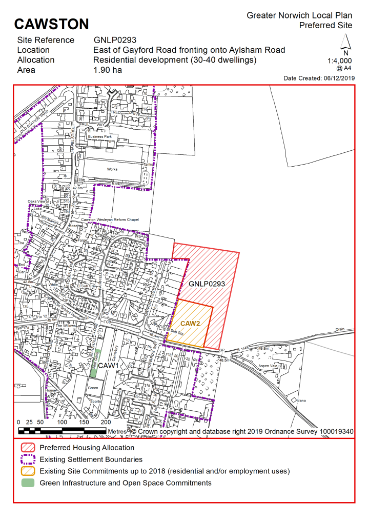
POLICY GNLP0293 Land East of Gayford Road, Cawston (approx. 1.90 ha, excluding existing CAW2 allocation) is allocated for residential development. The site is likely to accommodate 30-40 homes, 33% of which will be affordable. More homes may be accommodated, subject to acceptable design and layout as well as infrastructure constraints. The development will be expected to address the following specific matters:
|
Notes
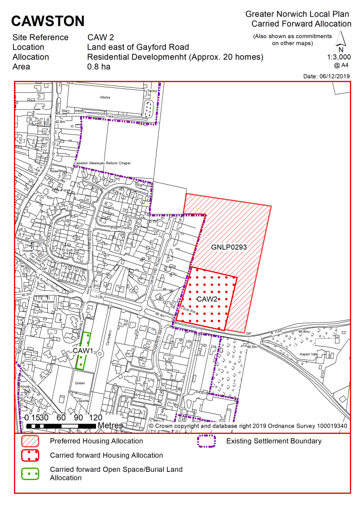
GNLP0293: This site is preferred for allocation as it is adjacent to the existing settlement limit, close to Cawston Primary School with minimal other constraints, although highway capacity would limit the site to a maximum of 100 dwellings. It is proposed to allocate only part of the much larger site with vehicular access through, or adjacent to, the existing Broadland Local Plan CAW2 allocation.
Existing allocations carried forward
|
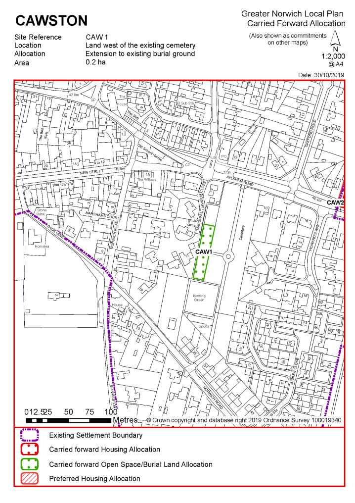
POLICY CAW1 Land to the west of the existing cemetery, Cawston (of approx. 0.2Ha) is allocated for an extension to the existing burial ground.
The development will be expected to address the following specific matters:
|
Notes
CAW1: This site was allocated in the 2016 local plan but has not yet been developed. The principle of development on the site has already been accepted and it is expected that development will take place within this local plan time-period up to 2038. The site is re-allocated for an extension to the cemetery.
|
POLICY CAW2 Land east of Gayford Road, Cawston (approx. 0.8ha) is allocated for residential development. The site will accommodate approximately 20 homes.
The development will be expected to address the following specific matters:
|
Notes
CAW2: This site was allocated in the 2016 local plan but has not yet been developed. The principle of development on the site has already been accepted and it is expected that development will take place within the time-period of this local plan up to 2038. The site is considered in the calculation of the housing requirement, providing at least 20 homes, but more may be accommodated, subject to an acceptable design and layout being achieved.
Adjacent land is proposed to be allocated for a further 30-40 new homes and both sites should be masterplanned together to bring forward a cohesive development.
|
Address |
Site Reference |
Area (ha) |
Promoted for |
Comments |
|
Cawston, Brandiston and Swannington |
||||
|
NO REASONABLE ALTERNATIVE SITES |
||||
Unreasonable Sites - Residential
|
Address |
Site Reference |
Area (ha) |
Promoted for |
Reason considered to be unreasonable |
|
Cawston, Brandiston and Swannington |
||||
| (3) | ||||
|
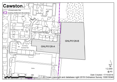
Land off Fred Tuddenham Drive |
GNLP0126 A and B |
0.42 + 1.18 |
14 residential dwellings and mixed use of 36 dwellings with commercial development |
These sites are reasonably well located in terms of form and character and accessibility to the services and facilities in Cawston, however they are considered to be unreasonable on highway grounds. Footway provision between the sites and the school is not continuous and would require multiple road/junction crossings. Children would need to make a challenging crossing at the Aylsham Road/Chapel Road junction and the footway at Aylsham Road is narrow with no scope for improvement. Clarification would also be needed that access can be gained to the highway without ransom. |
|
|
||||
|
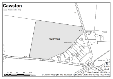
Heydon Road |
GNLP2134 |
3.14 |
Mixed use including 30 dwellings, care home and commercial uses |
This site is considered to be unreasonable for allocation because it is remote from the existing settlement limit and the services and facilities in Cawston. Development of this site would not be well related to the form and character of the settlement. There is no safe pedestrian route to Cawston Primary Academy and due to the distance, it is unlikely to be feasible or viable to provide one. |
|
|
||||
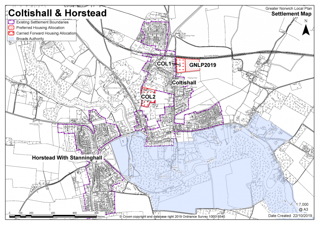
COLTISHALL, HORSTEAD WITH STANNINGHALL AND BELAUGH
The catchment of Coltishall Primary School brings Horstead with Stanninghall and Belaugh in to a village cluster. There is currently limited capacity at the school, although the site is not landlocked and could be expanded.
It is considered that as well as existing allocations, approximately 50-60 new homes are appropriate for the Coltishall cluster. The proposed new allocation does not amount to this figure; however, further development is not ruled out. Windfall development policy 7.4 allows an amount of growth in each village cluster that reflects primary school capacity. The villages have a wide range of core and secondary services, including good public transport links. The majority are in Coltishall and Horstead. Belaugh has very few services.
One site is identified as a preferred option, providing for between 20-25 new homes in the cluster. There are two carried forward residential allocations for 55 homes and a total of 15 additional dwellings with planning permission on small sites. This gives a total deliverable housing commitment for the cluster of between 88-93 homes between 2018 – 2038.
Horstead has a neighbourhood area designated and the parish council is working on an emerging Neighbourhood Plan (at time of writing). Any applications that are submitted for development within the parish should take into account the emerging Neighbourhood Plan for the area, in line with paragraph 48 of the National Planning Policy Framework').
All new and carried forward allocations are expected to address standard requirements associated with development. These vary from place to place, but are likely to include mitigations for flood risk (as well as SUDs), highways improvements, safeguarding of minerals resources, land remediation, measures to protect the environment, biodiversity, and landscape intrusion.
|
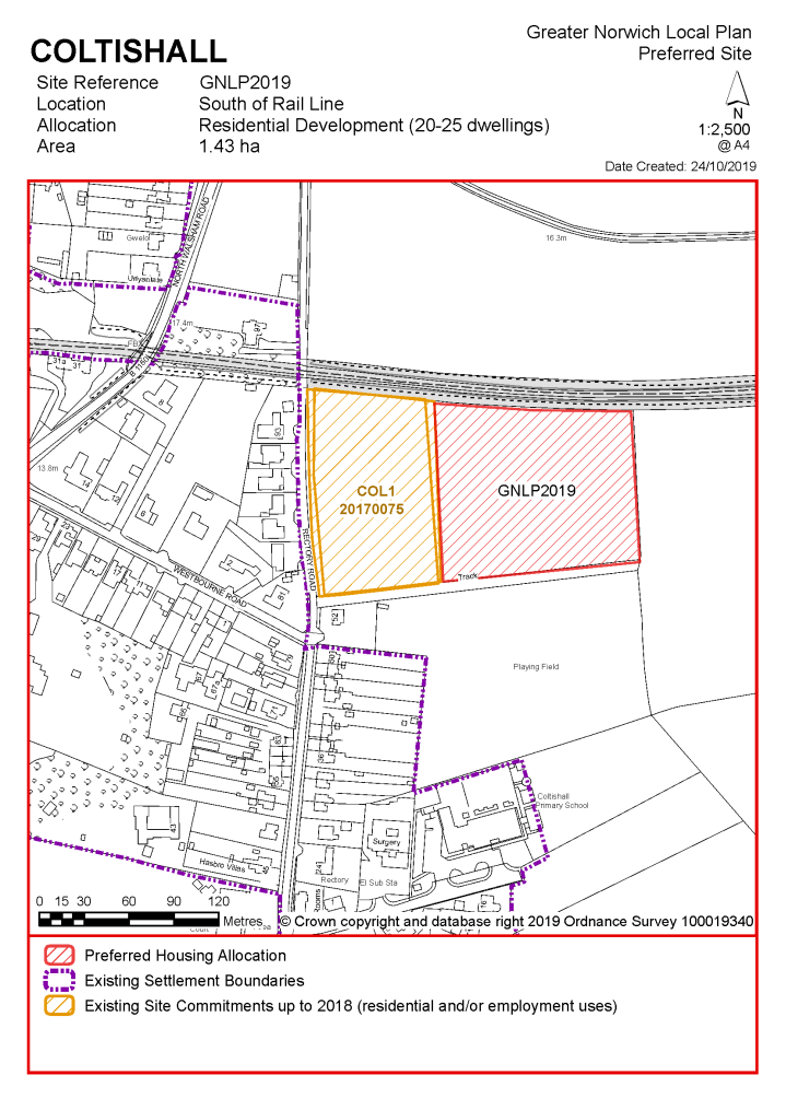
POLICY GNLP2019, Land at Rectory Road and south of the Bure Valley Railway, Coltishall (approx. 1.43 ha) is allocated for residential development. The site is likely to accommodate 20-25 homes, 33% of which will be affordable. More homes may be accommodated, subject to an acceptable design and layout, as well as infrastructure constraints. The development will be expected to address the following specific matters:
|
Notes
GNLP2019: After careful consideration this is the only site considered suitable for allocation in Coltishall. Vehicular access will need to be taken through adjacent existing Broadland Local Plan COL1 allocation and a Transport Assessment will be needed.
Existing allocations carried forward
|
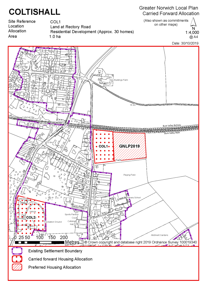
POLICY COL1 Land at Rectory Road, Coltishall (approx. 1.0ha) is allocated for residential development. This will accommodate approximately 30 homes.
The development will be expected to address the following specific matters:
|
Notes
COL1: This site was allocated in the 2016 local plan but has not yet been developed. The principle of development on the site has already been accepted and it is expected that development will take place within the time-period of this local plan up to 2038. The site is considered in the calculation of the housing requirement, providing at least 30 homes, but more may be accommodated, subject to an acceptable design and layout being achieved.
|
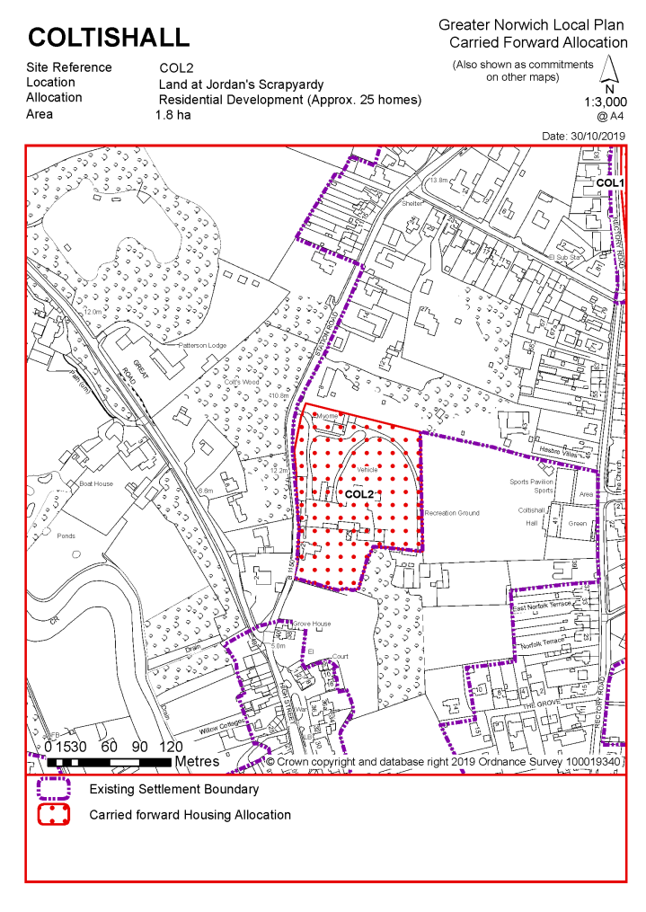
POLICY COL2 Land at Jordan's Scrapyard, Coltishall (approx. 1.8ha) is allocated for residential development. This will accommodate approximately 25 homes.
The development will be expected to address the following specific matters:
|
Notes
COL2: This site was allocated in the 2016 local plan but has not yet been developed. The principle of development on the site has already been accepted and it is expected that development will take place within the time-period of this local plan up to 2038. The site is considered in the calculation of the housing requirement, providing at least 25 homes, but more may be accommodated, subject to an acceptable design and layout being achieved.
|
Address |
Site Reference |
Area (ha) |
Promoted for |
Comments |
|
Coltishall, Horstead with Stanninghall and Belaugh |
||||
|
NO REASONABLE ALTERNATIVE SITES |
||||
Unreasonable Sites - Residential
|
Address |
Site Reference |
Area (ha) |
Promoted for |
Reason considered to be unreasonable |
|
Coltishall, Horstead with Stanninghall and Belaugh |
||||
|
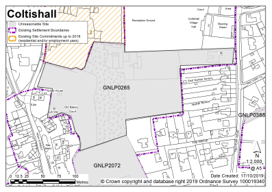
Land south of Jordans Scrapyard, Coltishall |
GNLP0265 |
2.51 |
25-30 dwellings |
Although this site is well located with a safe pedestrian route to Coltishall Primary School it is considered to be unreasonable for allocation due to heritage and landscape issues. This site is adjacent to the conservation area and its current landscaping is important to the setting. This land is on a higher level behind the street frontage with a sharp embankment and mature landscaping. Significant tree cover on the site would reduce the number of dwellings which could be achieved. The site's location between two bends would make achieving adequate visibility challenging. It is an unsuitable location for increased stopping and turning movements and pedestrians crossing. |
|
|
||||
| (1) | ||||
|
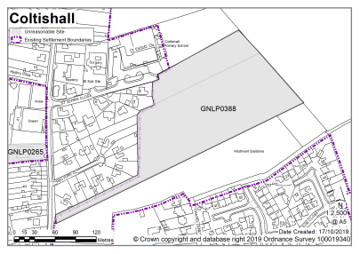
Land at St John's Close, Coltishall |
GNLP0388 |
2.98 |
Approx. 35 dwellings |
This site is well located near to Coltishall Primary School but is considered to be unreasonable for allocation on highway grounds. The site has two potential points of access (south of Rectory Close and via St John's Close). South of Rectory Close is narrow and it would not be feasible to achieve an acceptable visibility splay. St Johns Close is a cul-de-sac where Coltishall Primary School is located. There is an existing parking issue on the road and as such it would not be appropriate to service a development from it. The conflict between development and school traffic/parking would result in a safety concern. |
|
|
||||
|
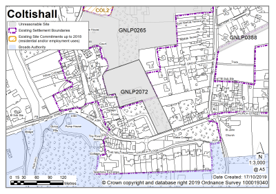
East of High Street, Coltishall |
GNLP2072 |
1.12 |
15 dwellings |
Although this site is well located with a safe pedestrian route to Coltishall Primary School it is considered to be unreasonable for allocation due to heritage and Tree Preservation Order issues. Highway visibility could be challenging and would probably require removal of a wall. The site is located on a bend which restricts forward visibility and there is a safety concern regarding increased stopping and turning movements as the carriageway is constrained immediately to the west. |
|
|
||||
| (1) | ||||
|
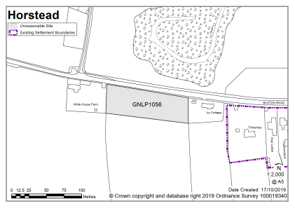
Land at Buxton Road, Horstead |
GNLP1056 |
0.46 |
Up to 20 dwellings |
This site is considered to be unreasonable for allocation as it is some distance from the primary school and other services and facilities in Coltishall and there are site access and landscape issues. Development of this site would not be well related to the form and character of the settlement. |
|
|
||||
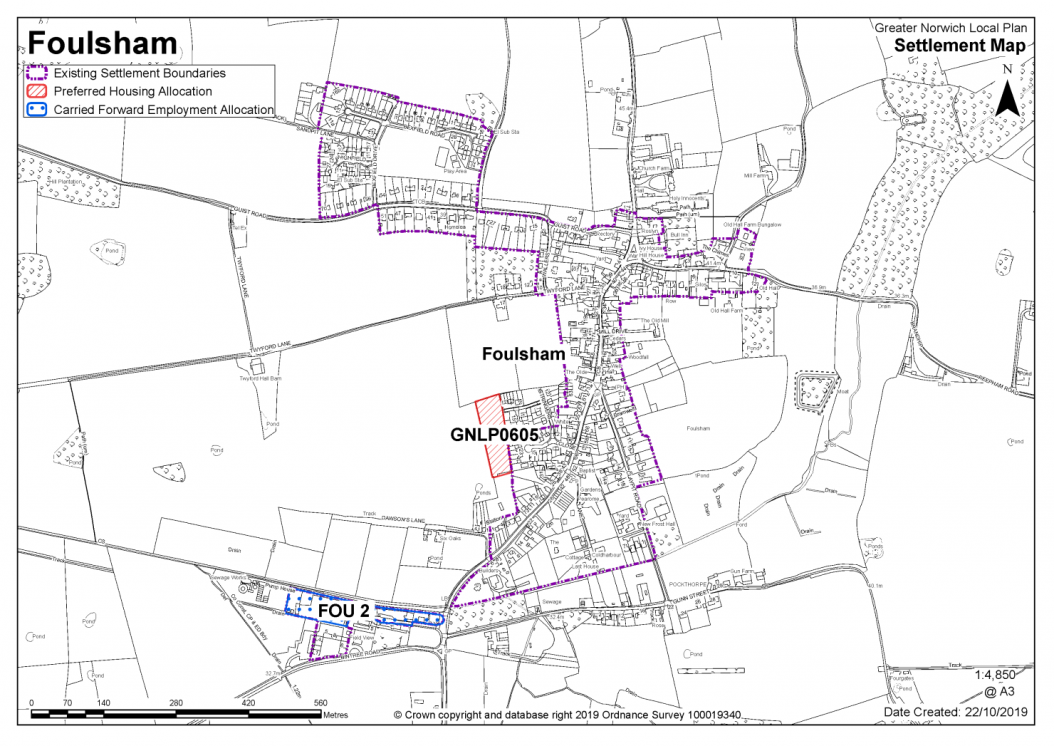
The catchment of Foulsham Primary School brings Foulsham and Themelthorpe into a village cluster. The school lacks capacity but the site is not landlocked so there is the potential for expansion.
It is considered that as well as existing allocations and windfall development, approximately 12-20 new homes is appropriate for the Foulsham cluster.
Apart from the primary school, Foulsham has a number of services and facilities including a village hall, pub, shop and some local employment opportunities. Themelthorpe lacks services.
One site is identified as a preferred option, providing for between 12-15 new homes in the cluster. There are no carried forward residential allocations but there is a total of 11 additional dwellings with planning permission on small sites. This gives a total deliverable housing commitment for the cluster of between 23-26 homes between 2018-2038.
All new and carried forward allocations are expected to address standard requirements associated with development. These vary from place to place, but are likely to include mitigations for flood risk (as well as SUDs), highways improvements, safeguarding of minerals resources, land remediation, measures to protect the environment, biodiversity, and landscape intrusion.
|
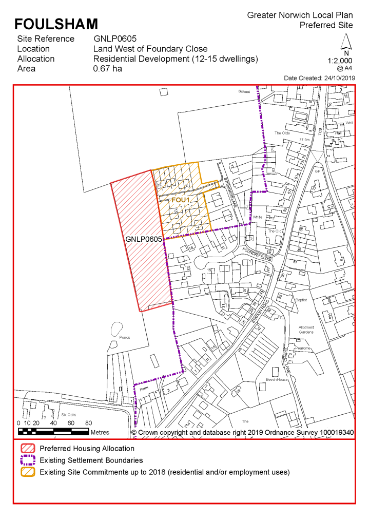
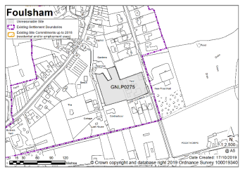
POLICY GNLP0605– Land west of Foundry Close, Foulsham (0.67ha) is allocated for residential development. The site is likely to accommodate 12-15 homes, 33% of which will be affordable. More homes may be accommodated, subject to an acceptable design and layout, as well as infrastructure constraints. The development will be expected to address the following specific matters:
|
Notes
GNLP0605: This is the only site considered suitable for allocation in Foulsham. The site is located next to the existing Broadland Local Plan FOU1 allocation, which is now built out, and has a safe pedestrian route to the local primary school. The site is allocated subject to connection to Aubrey Rix Close. The allocation of this site is subject to confirmation on identified waste water quality issues.
Existing allocation carried forward
|
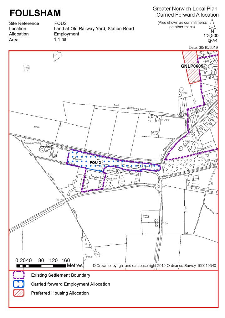
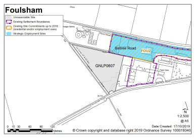
POLICY FOU2 Land at Old Railway Yard, Station Road, Foulsham (approx. 1.1ha) is allocated for employment use (Use Class B1, B2, B8).
The development will be expected to address the following specific matters:
|
This site was allocated in the 2016 local plan but has not yet been developed. The principle of development on the site has already been accepted and it is expected that development will take place within the time-period of this local plan up to 2038. The site is re-allocated for employment/commercial development.
|
Address |
Site Reference |
Area (ha) |
Promoted for |
Comments |
|
Foulsham and Themelthorpe |
||||
|
NO REASONABLE ALTERNATIVE SITES |
||||
FREETHORPE, HALVERGATE AND WICKHAMPTON
The catchment of Freethorpe Community Primary School brings Freethorpe, Halvergate and Wickhampton into a village cluster. The school currently has capacity and is not landlocked so there is the potential for expansion.
It is considered that as well as existing allocations and windfall development, approximately 40 homes are considered appropriate for the Freethorpe, Halvergate and Wickhampton cluster. The cluster has a range of facilities that includes a village hall, pub, church, and public transport services which are concentrated mostly in Freethorpe.
Consequently, one site is identified as a preferred option, providing for between 30-40 new homes in the cluster. There is one carried forward residential allocation for 10 homes and a total of 10 additional dwellings with planning permission on small sites. This gives a total deliverable housing commitment for the cluster of between 50-60 homes between 2018-2038.
All new and carried forward allocations are expected to address standard requirements associated with development. These vary from place to place, but are likely to include mitigations for flood risk (as well as SUDs), highways improvements, safeguarding of minerals resources, land remediation, measures to protect the environment, biodiversity, and landscape intrusion.
|
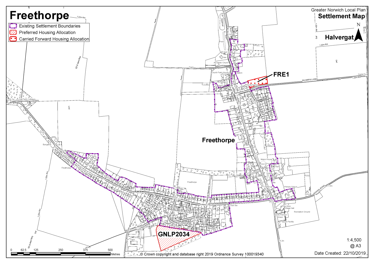
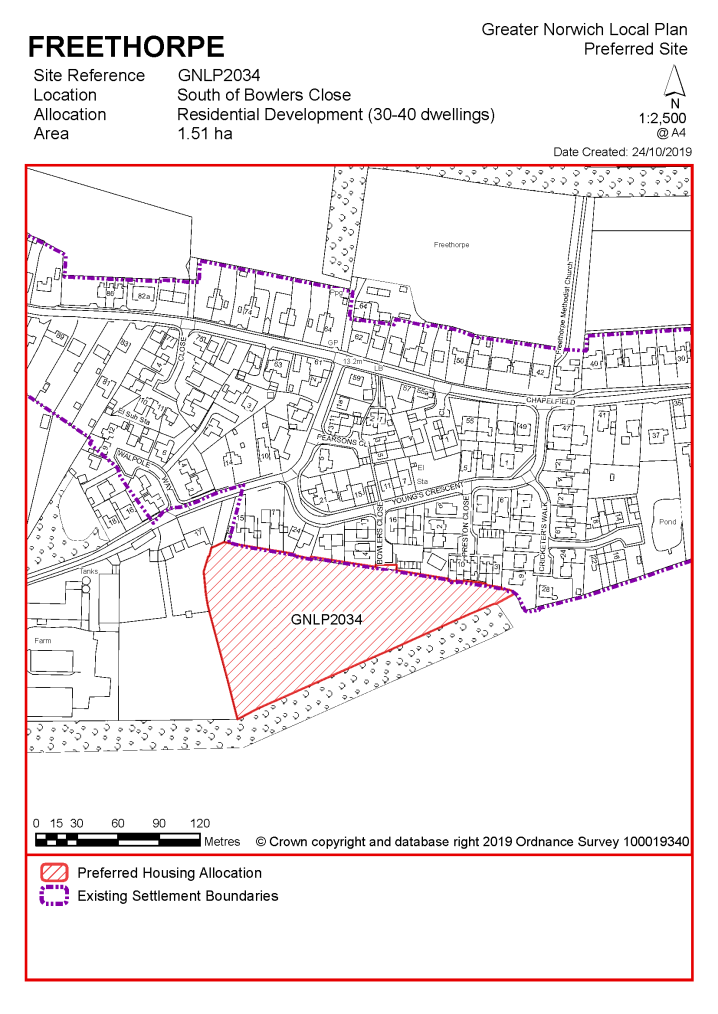
POLICY GNLP2034 - South of Bowlers Close, Freethorpe (approx. 1.51ha) is allocated for residential development. The site is likely to accommodate 30-40 homes, 33% of which will be affordable. More homes may be accommodated, subject to an acceptable design and layout as well as infrastructure constraints. The development will be expected to address the following specific matters:
|
Notes
GNLP2034: This site is preferred for allocation as it is well related to the village with a safe pedestrian route to Freethorpe Primary School. It is the only site promoted capable of accommodating the level of development identified for the cluster. The site is allocated subject to access via Bowlers Close, although the promoter will need to demonstrate that they can provide a footway and carriageway of adequate width to enable safe access.
Existing allocation carried forward
|
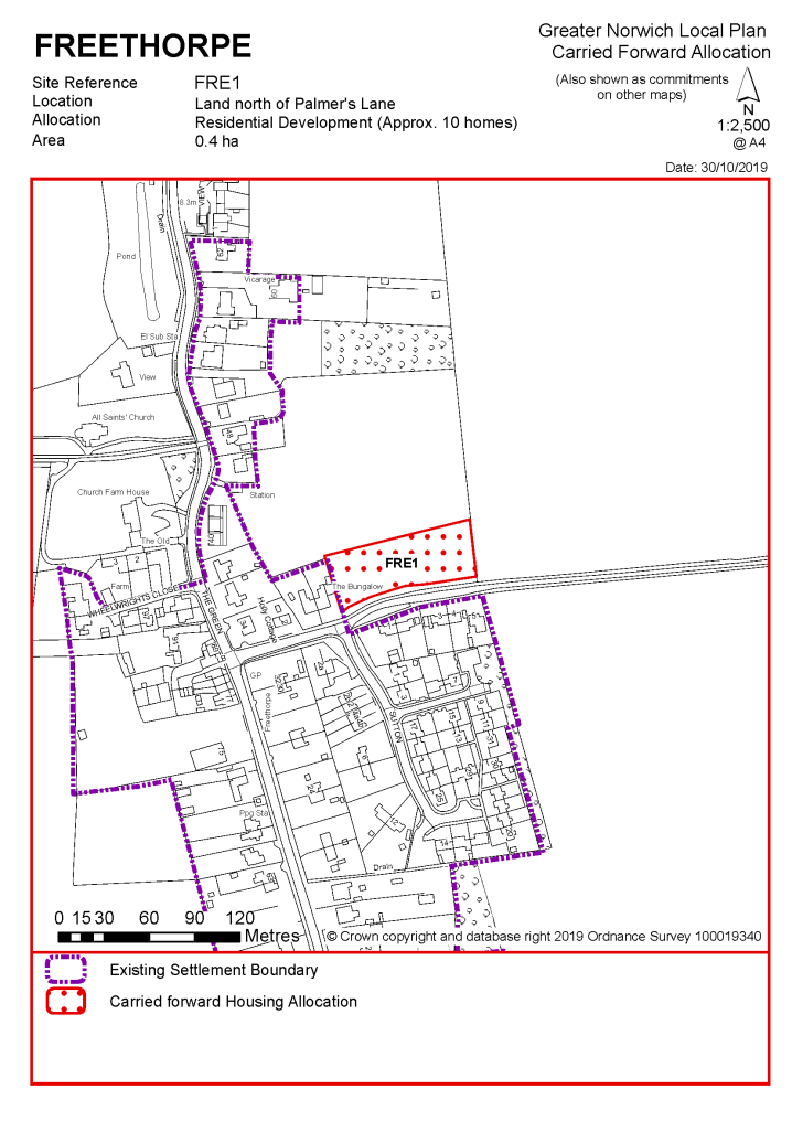
POLICY FRE1 Land north of Palmer's Lane, Freethorpe (approx. 0.4ha) is allocated for residential development. This will accommodate approximately 10 homes.
The development will be expected to address the following specific matters:
|
Notes
FRE1: This site was allocated in the 2016 local plan but has not yet been developed. The principle of development on the site has already been accepted and it is expected that development will take place within the time-period of this local plan up to 2038. The site is considered in the calculation of the housing requirement, providing at least 10 homes, but more may be accommodated, subject to an acceptable design and layout being achieved.
|
Address |
Site Reference |
Area (ha) |
Promoted for |
Comments |
|
Freethorpe, Halvergate and Wickhampton |
||||
|
NO REASONABLE ALTERNATIVE SITES |
||||
Unreasonable Sites - Residential
Frettenham is not clustered with other settlements, as the school catchment does not extend to adjoining villages. The school currently has capacity, but the site is landlocked making further expansion difficult. As well as the primary school, services include a peak hour bus service to and from higher order settlements.
Whilst it is considered the cluster could accommodate development of 50-60 additional homes, there are currently no new allocations proposed and no allocations to be carried forward in this cluster. There are however 3 dwellings with planning permission on small sites. No new allocations are proposed but further development is not ruled out. Windfall development policy 7.4 allows an amount of growth in each village cluster that reflects primary school capacity. See settlement map for the extent of existing settlement limits.
No existing allocations to be carried forward.
|
Address |
Site Reference |
Area (ha) |
Promoted for |
Comments |
|
Frettenham |
||||
|
NO REASONABLE ALTERNATIVE SITES |
||||
Unreasonable Sites - Residential
|
Address |
Site Reference |
Area (ha) |
Promoted for |
Reason considered to be unreasonable |
|
Frettenham |
||||
| (5) | ||||
|
Land south of Harbord Road |
GNLP0492 |
6.37 |
Residential (unspecified number and enabling large area of GI) |
This site has a safe walking route to Frettenham Primary School but is not considered to be suitable for allocation as it has a number of constraints. The site is partly within a County Wildlife Site and is heavily constrained by Tree Preservation Orders and ecological and landscape issues. In highway terms access via Harbord Road would not be acceptable due to visibility constraints. Development in this location has already been tested through the planning application and appeal process. |
|
|
||||
| (2) | ||||
|
Adjacent 10 Buxton Road |
GNLP2078 |
1.42 |
25 dwellings |
This site is considered to be unreasonable as it is remote from the main built up area of the village with no safe pedestrian route to Frettenham Primary School. The site appears to be surrounded by commercial development so residential development would not be a good fit here because of potential amenity issues. |
|
|
||||
Unreasonable Sites - Non-Residential
|
Address
|
Site Reference |
Area (ha) |
Proposal
|
Reason considered to be unreasonable |
|
Frettenham |
||||
| (2) | ||||
|
Adjacent 10 Buxton Road, Frettenham |
GNLP2076 |
0.39 |
Employment |
This site has the potential to provide local employment opportunities but is not preferred for allocation at the current time. To justify a local plan allocation in this location more evidence would be required about the need for the proposal and how it would be delivered. A proposal of this scale would probably be better dealt with through the planning application process. |
|
|
||||
Great and Little Plumstead is not clustered with other settlements as the school catchment does not extend to adjoining villages. There is currently capacity at the school. Services include a village hall and public transport service.
Great and Little Plumstead has a made neighbourhood plan which covers the same area as that of the parish boundary. The Plan was made in July 2015 and covers the period to 2034. It contains a series of policies that look to shape development within the neighbourhood area. There are policies within the plan that will be of relevance to development and any applications that are submitted for development within the parish should have due regard to those policies.
Whilst it is considered the cluster could accommodate development of 50-60 additional homes, there are currently no new allocations proposed and no allocations to be carried forward in this cluster. There are however 129 dwellings with planning permission on a number of sites. No new allocations are proposed but further development is not ruled out. Windfall development policy 7.4 allows an amount of growth in each village cluster that reflects primary school capacity. See settlement map for the extent of existing settlement limits.
(1) No new allocations proposed.
No existing allocations to be carried forward.
|
Address |
Site Reference |
Area (ha) |
Promoted for |
Comments |
|
Great and Little Plumstead |
||||
|
NO REASONABLE ALTERNATIVE SITES |
||||
Unreasonable Sites - Residential
|
Address |
Site Reference |
Area (ha) |
Promoted for |
Reason considered to be unreasonable |
|
Great and Little Plumstead |
||||
| (2) | ||||
|
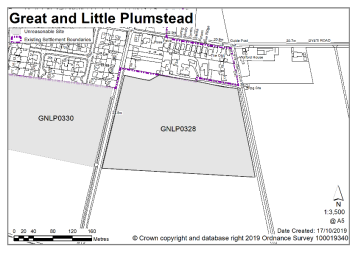
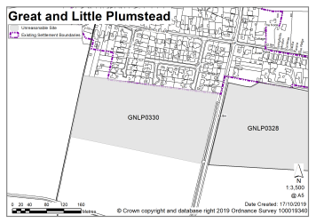
Land east of Salhouse Road |
GNLP0328 |
5.18 |
Approx. 110-165 dwellings |
This site is not considered to be reasonable for allocation due to the level of highway improvements that would be needed at the 'Brick Kilns' junction in the form of junction realignment or a roundabout. |
|
|
||||
| (2) | ||||
|
Land west of Salhouse Road |
GNLP0330 |
4.90 |
108-162 dwellings |
This site is not considered to be reasonable for allocation due to the level of highway improvements that would be needed at the 'Brick Kilns' junction in the form of junction realignment or a roundabout. |
|
|
||||
| (3) | ||||
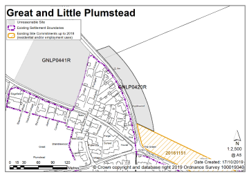
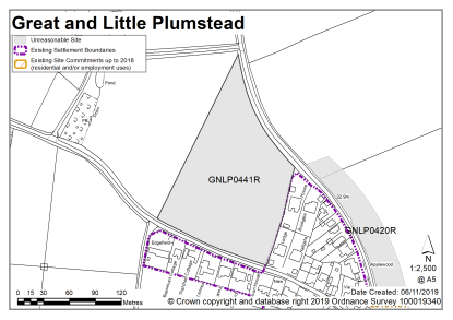
|
Land at Hare Road |
GNLP0420R |
10.93 |
10-15 dwellings |
This site is not considered to be reasonable for allocation as there is not a continuous safe walking route to Little Plumstead Primary School. Although planning application 20161151 will provide part of the footway connection, visibility at the Church Road/Hare Road junction is poor. |
|
|
||||
| (1) | ||||
|
Land at Middle Road |
GNLP0441R |
4.23 |
30 dwellings |
This site is not considered to be reasonable for allocation as there is not a continuous safe walking route to Little Plumstead Primary School. Planning application 20161151 will provide part of the footway connection but the local highway authority does not support the allocation of this site as visibility at the Church Road/Hare Road junction is poor. |
|
|
||||
| (3) | ||||
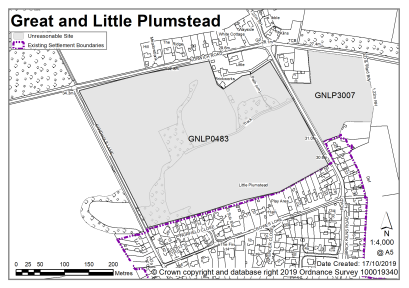
|
Land east of Salhouse Road |
GNLP0483 |
11.12 |
86 dwellings with 5.83 ha of green infrastructure and new play equipment |
This site is not considered to be reasonable for allocation due to the level of highway improvements that would be needed at the 'Brick Kilns' junction in the form of junction realignment or a roundabout. |
|
|
||||
| (2) | ||||
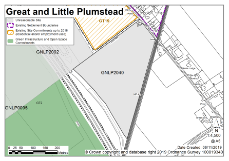
|
South of Broad Lane |
GNLP2040 |
7.60 |
Residential (unspecified number) |
This site is not considered to be reasonable for allocation as there is no safe pedestrian route to Little Plumstead Primary School over 3km away, which is the catchment school. There is a school closer in Rackheath but this site would be better delivered after site GT19 has been developed which is likely to provide improved footway links. The frontage of the site is affected by surface water flood risk. |
|
|
||||
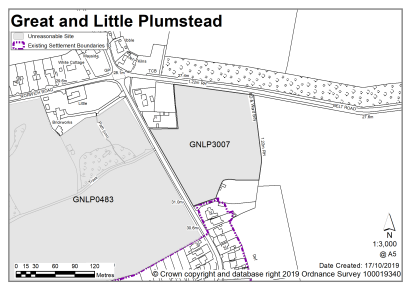
| (2) | ||||
|
East of Salhouse Road, South of Belt Road |
GNLP3007 |
2.05 |
8-10 dwellings |
This site is not considered to be reasonable for allocation due to the level of highway improvements that would be needed at the 'Brick Kilns' junction in the form of junction realignment or a roundabout. |
|
|
||||
| (3) | ||||
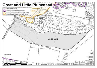
|
Home Farm, Water Lane |
GNLP3014 |
14.26 |
300 dwellings |
This site is not considered to be reasonable for allocation. The site as submitted is too large so frontage development is likely to be more acceptable, however there is an area of surface water flood risk on the likely access point into the site. |
|
|
||||
Unreasonable Sites - Non-Residential
|
Address |
Site Reference |
Area (ha) |
Promoted for |
Reason considered to be unreasonable |
|
Great and Little Plumstead |
||||
| (2) | ||||
|
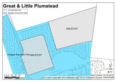
North of Octagon Business Park, Gt & Lt Plumstead |
GNLP2107 |
1.62 |
Office, storage |
This site has the potential to provide local employment opportunities but is not preferred for allocation at the current time. To justify a local plan allocation in this location more evidence would be required about the need for the proposal and how it would be delivered. A proposal of this scale would probably be better dealt with through the planning application process. |
|
|
||||
| (1) | ||||
|
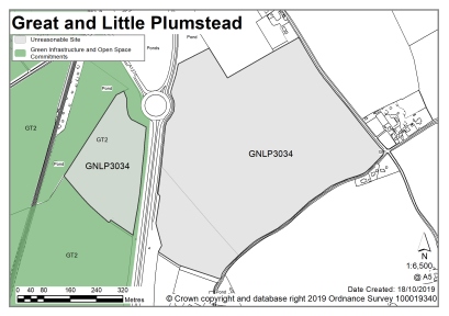
East of Brook Farm, Gt & Lt Plumstead |
GNLP3034 |
36.84 |
Employment B1, B2, B8 |
This site is not considered to be suitable for allocation as evidence suggests that currently committed land is more than sufficient in quantity and quality to meet the employment growth needs in Greater Norwich. There is therefore no need to allocate any additional large-scale employment sites in the new local plan. |
|
|
||||
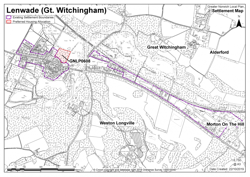
GREAT WITCHINGHAM, LENWADE, WESTON LONGVILLE, ALDERFORD, ATTLEBRIDGE, LITTLE WITCHINGHAM AND MORTON-ON-THE-HILL
The catchment of Great Witchingham Primary Academy brings Great Witchingham, Lenwade, Weston Longville, Alderford, Attlebridge, Little Wichingham and Morton on the Hill into a village cluster. The school has significant capacity issues and it is very small and landlocked.
It is considered that as well as existing allocations and windfall development, approximately 12-20 new homes are appropriate for the Great Witchingham cluster. The cluster has a range of facilities including a primary school, food shop, pub, petrol station, doctor's surgery and industrial estate.
One site is identified as a preferred option, providing for between 15-20 new homes in the cluster. There are no carried forward residential allocations but there is a total of 28 additional dwellings with planning permission on small sites. This gives a total deliverable housing commitment for the cluster of between 43-48 homes between 2018-2038.
All new and carried forward allocations are expected to address standard requirements associated with development. These vary from place to place, but are likely to include mitigations for flood risk (as well as SUDs), highways improvements, safeguarding of minerals resources, land remediation, measures to protect the environment, biodiversity, and landscape intrusion.
|
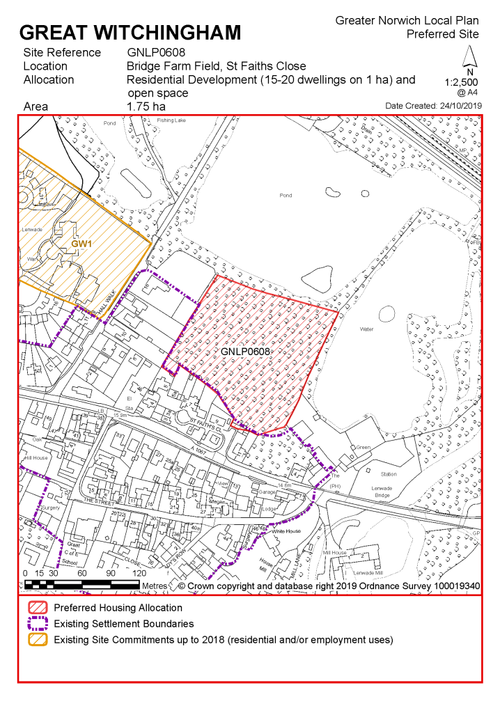
Policy GNLP0608 – Land at Bridge Farm Field, St Faiths Close, Great Witchingham, 1.75ha is allocated for residential development (approx. 1ha with remainder of the site as open space). The site is likely to accommodate 15-20 homes, 33% of which will be affordable. More homes may be accommodated, subject to an acceptable design and layout, as well as infrastructure constraints. The development will be expected to address the following specific matters:
|
Notes
GNLP0608: This is the only site in the cluster that has any possibility to provide a safe pedestrian route to Great Witchingham Primary Academy. The site is preferred for allocation, but the promoter will need to provide evidence that vehicular access is achievable as there appears to be a ransom strip between the offered land and the highway. One hectare of the site is proposed for residential development with the remainder as open space to reflect the setting and proximity to a County Wildlife Site.
No existing allocations to be carried forward.
|
Address |
Site Reference |
Area (ha) |
Promoted for |
Comments |
|
Great and Little Plumstead |
||||
|
NO REASONABLE ALTERNATIVE SITES |
||||
Unreasonable Sites - Residential
|
Address |
Site Reference |
Area (ha) |
Promoted for |
Reason considered to be unreasonable |
|
Great Witchingham, Lenwade, Weston Longville, Alderford, Attlebridge, Little Witchingham and Morton on the Hill |
||||
|
Land off Fakenham Road, Attlebridge |
GNLP0460 |
6.08 |
Approx. 40 dwellings |
Allocation of this site would lead to disconnected development along the Fakenham Road with limited accessibility to services and facilities and no safe pedestrian route to Great Witchingham Primary Academy 5.6km away, other non-catchment schools are closer to the site but still a 3km distance away. Access would be directly onto the A1067 Fakenham Road which would be unlikely to be acceptable in highway terms. |
|
|
||||
| (2) | ||||
|
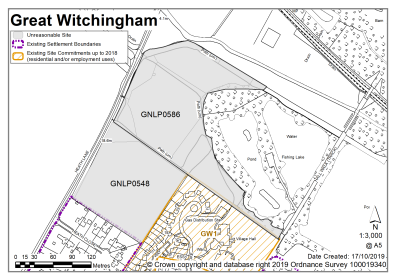
Council Field, Great Witchingham/Lenwade |
GNLP0548 |
1.81 |
Residential (unspecified number) |
This site is within walking distance of Great Witchingham Primary Academy but it is considered to be unreasonable for allocation as Heath Lane is narrow with no footway and there is no scope for improving the carriageway width or providing a footway, therefore it is not possible to deliver a safe route to school. There is considered to be a better site to meet the capacity identified for the cluster. |
|
|
||||
|
Weston Hall, Weston Longville |
GNLP0553 |
5.18 |
Approx. 5 dwellings |
This site is considered to be unreasonable for allocation as it is separated from the existing built up area and development here would not be well related to the form and character of the settlement. In addition, there are significant flood risk issues on part of the site and no safe pedestrian route to Great Witchingham Primary Academy. |
|
|
||||
|
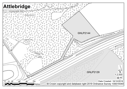
Adjoining Fakenham Road, Attlebridge |
GNLP2129 |
7.22 |
200 dwellings and commercial |
Allocation of this site would lead to disconnected development along the Fakenham Road with limited accessibility to services and facilities and no safe route to Great Witchingham Primary Academy 6.4km away. Other non-catchment schools are closer to the site but still a 3km distance away. Access would be directly onto the A1067 Fakenham Road which would be unlikely to be acceptable in highway terms. |
|
|
||||
|
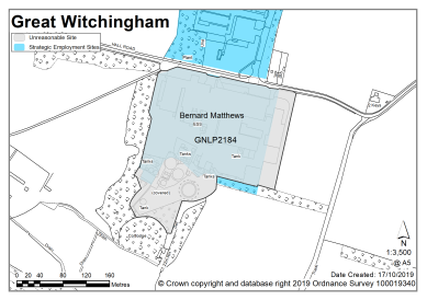
Bernard Matthews South Site, Great Witchingham |
GNLP2184 |
5.00 |
150 dwellings |
This is a large brownfield site beyond the edge of the village with no footways to connect it, and too far to walk to local services and facilities, including Great Witchingham Primary Academy. Despite it being brownfield, the site is considered to be unreasonable for allocation because development here would not be well related to the form and character of the settlement. There may also be possible contamination issues on the site which would need to be resolved. |
|
|
||||
Unreasonable Sites - Non-Residential
HAINFORD AND STRATTON STRAWLESS
The catchment of Hainford Primary School brings Hainford together with Stratton Strawless into a village cluster. The school currently has capacity, but is landlocked which would prevent further expansion. In addition to the primary school, services in the cluster include a village hall and public transport service.
Whilst it is considered the cluster could accommodate development of 50-60 additional homes, there are currently no new allocations proposed and no allocations to be carried forward in this cluster. There are however 7 dwellings with planning permission on small sites. No new allocations are proposed but further development is not ruled out. Windfall development policy 7.4 allows an amount of growth in each village cluster that reflects primary school capacity. See settlement map for the extent of existing settlement limits.
(1) No new allocations proposed.
No existing allocations to be carried forward.
|
Address |
Site Reference |
Area (ha) |
Promoted for |
Comments |
|
Hainford and Stratton Strawless |
||||
|
NO REASONABLE ALTERNATIVE SITES |
||||
Unreasonable Sites - Residential
|
Address |
Site Reference |
Area (ha) |
Promoted for |
Reason considered to be unreasonable |
|
Hainford and Stratton Strawless |
||||
|
Land at the junction of Frettenham Road and Buxton Road |
GNLP0065 |
1.04 |
10-12 dwellings |
This site is not considered to be suitable for allocation as there is no safe pedestrian route to Hainford Primary School and due to the distance it would not be feasible or viable to provide one. |
|
|
||||
|
Land off Stratton Road |
GNLP0069 |
10.70 |
Approx. 404 dwellings with associated open space |
This site is considered to be unreasonable for allocation as even a smaller area of development than the site proposed would have a significant visual impact and breakout into open countryside. There are also highway concerns. Hainford Road is narrow, and it is unlikely to be feasible to widen it to an acceptable standard and provide a footway to connect with the existing footway to the south. The highway extent at the north west corner of the Stratton Road junction with Waterloo Road is also a constraint with compromised visibility. |
|
|
||||
| (1) | ||||
|
Land at Hall Road |
GNLP0181 |
1.16 |
Approx. 20 dwellings |
Although this site is adjacent to the existing settlement limit it is not considered reasonable for allocation as there is no safe pedestrian route to Hainford Primary School and due to the distance it would not be feasible or viable to provide one. |
|
|
||||
|
Arable Land, Hall Lane |
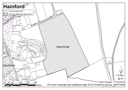
GNLP0190 |
8.44 |
Residential development (unspecified number) with potential recreation area and leisure, community use and open space |
This is site is considered to be unreasonable for allocation as it is located some distance from the existing settlement limit and development in this location would be out of keeping with the form and character of Hainford. There is no safe pedestrian route to Hainford Primary School and due to the distance it would not be feasible or viable to provide a footway. |
|
|
||||
| (1) | ||||
|
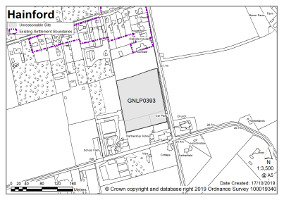
Land at Hainford |
GNLP0393 |
1.51 |
Approx. 45 dwellings |
This site is well located next to Hainford Primary School however it is not considered appropriate for allocation due to significant surface water flood issues. |
|
|
||||
|
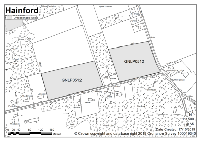
Lady Lane/ Hall Road |
GNLP0512 |
3.60 |
Approx. 12 dwellings |
This site is not considered to be suitable for allocation as there is no safe pedestrian route to Hainford Primary School and due to the distance it would not be feasible or viable to provide one. |
|
|
||||
|
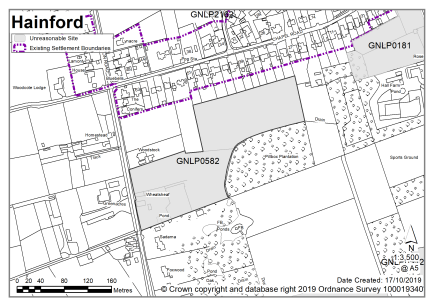
Land east of Newton Road |
GNLP0582 |
3.00 |
60-80 dwellings with consideration of community use |
This site is not considered to be suitable for allocation as there is no safe pedestrian route to Hainford Primary School and due to the distance it would not be feasible or viable to provide one. |
|
|
||||
|
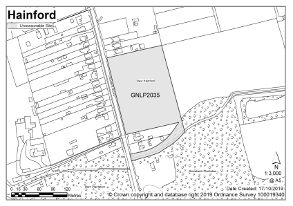
West of Cromer Road |
GNLP2035 |
2.31 |
25 dwellings |
This site is considered to be unreasonable for allocation as it is quite some distance from the existing settlement limit and development in this location would be out of keeping with the form and character of Hainford. There is no safe pedestrian route to Hainford Primary School and due to the distance it would not be feasible or viable to provide a footway. Direct vehicular access onto the A140 is unlikely to be acceptable. |
|
|
||||
| (1) | ||||
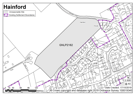
|
Harvest Close |
GNLP2162 |
2.50 |
60 dwellings |
Although this site is adjacent to the existing settlement limit it is not considered reasonable for allocation as there is no safe pedestrian route to Hainford Primary School and due to the distance it would not be feasible or viable to provide a footway. |
|
|
||||
Hevingham is not clustered with other settlements as the school catchment does not extend to adjoining villages. The school is currently close to capacity, but is not landlocked so there is potential for expansion. In addition to the primary school, services include a village hall, pub and public transport.
Whilst it is considered the cluster could accommodate development of 20-50 additional homes, there are currently no new allocations proposed and no allocations to be carried forward in this cluster. There are however 4 dwellings with planning permission on small sites. No new allocations are proposed but further development is not ruled out. Windfall development policy 7.4 allows an amount of growth in each village cluster that reflects primary school capacity. See settlement map for the extent of existing settlement limits.
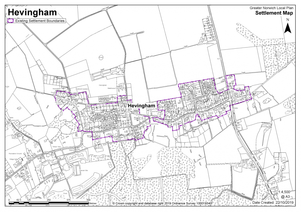
No existing allocations to be carried forward.
|
Address |
Site Reference |
Area (ha) |
Promoted for |
Comments |
|
Hevingham |
||||
|
NO REASONABLE ALTERNATIVE SITES |
||||
|
Address |
Site Reference |
Area (ha) |
Promoted for |
Reason considered to be unreasonable |
|
Hevingham |
||||
|
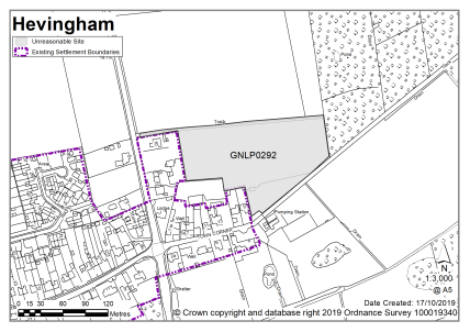
Land at Hevingham |
GNLP0292 |
1.75 |
Approx. 35 dwellings with a potential play area, open p Space and local infrastructure |
Although this site is within walking distance of Hevingham Primary School pedestrian access would require crossing the A140 which is not considered to constitute a safe route to school therefore the site is not preferred for allocation. |
|
|
||||
| (1) | ||||
|
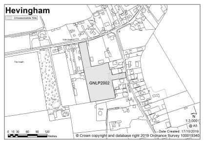
6 The Turn |
GNLP2002 |
1.13 |
15+ dwellings |
This site is considered to be unreasonable for allocation as it is located in The Heath which is some distance to the west of the services and facilities in main part of Hevingham village. This part of the village does not have a settlement limit. The Turn is a narrow lane without footways with limited possibility for improvement and consequently it is not possible to achieve a safe walking route to Hevingham Primary School. |
|
|
||||
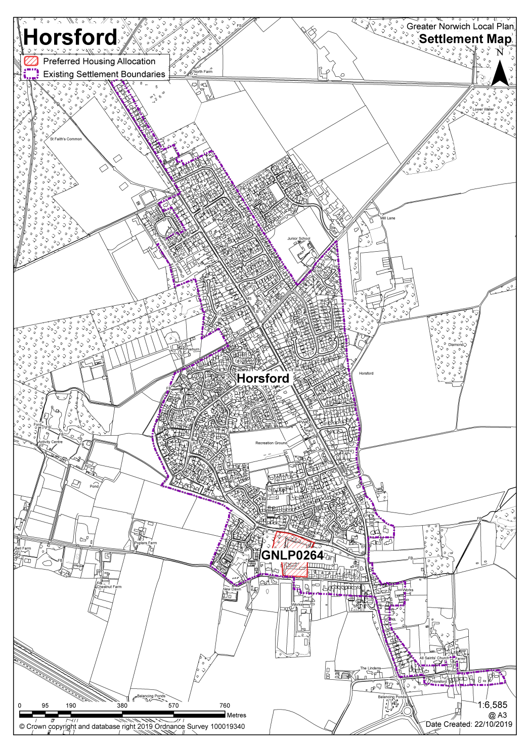
HORSFORD, FELTHORPE AND HAVERINGLAND
The catchment of Horsford Primary School brings Horsford, Felthorpe and Haveringland into a village cluster. The school currently has limited capacity.
It is considered that as well as existing commitments and windfall development, approximately 20-50 new homes are appropriate for the Horsford cluster. In addition to the primary school, services include a shop, doctor's surgery, village hall, library and public house.
One site is identified as a preferred option, providing for between 30-40 new homes in the cluster. There are no carried forward residential allocations but there is a total of 394 additional dwellings with planning permission on a variety of sites. This gives a total deliverable housing commitment for the cluster of between 424 -434 homes between 2018-2038.
Horsford has a made neighbourhood plan which covers the same area as that of the parish boundary. The Plan was made in July 2018 and covers the period to 2038. It contains a series of policies that look to shape development within the neighbourhood area. There are policies within the plan that will be of relevance to development and any applications that are submitted for development within the parish should have due regard to those policies.
All new and carried forward allocations are expected to address standard requirements associated with development. These vary from place to place, but are likely to include mitigations for flood risk (as well as SUDs), highways improvements, safeguarding of minerals resources, land remediation, measures to protect the environment, biodiversity, and landscape intrusion.
|
POLICY GNLP0264, Dog Lane, Horsford, (approx. 1.76ha) is allocated for residential development. The site is likely to accommodate 30-40 homes, 33% of which will be affordable. More homes may be accommodated, subject to an acceptable design and layout, as well as infrastructure constraints. The development will be expected to address the following specific matters:
|
Notes
GNLP0264: This proposal is for the redevelopment of a soft play centre and other commercial premises. It is preferred for allocation as it is a brownfield sites which is well related to the form and character of Horsford although the proximity to remaining industrial uses will need to be considered. The site is only acceptable for development if access is taken from Horsbeck Way as Dog Lane and it's junction with the Holt Road are not suitable for additional traffic.
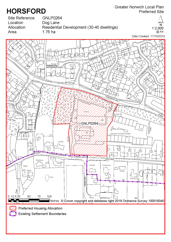
No existing allocations to be carried forward
|
Address |
Site Reference |
Area (ha) |
Promoted for |
Comments |
|
Horsford, Felthorpe and Haveringland |
||||
|
NO REASONABLE ALTERNATIVE SITES |
||||
|
Address |
Site Reference |
Area (ha) |
Promoted for |
Reason considered to be unreasonable |
|
Horsford, Felthorpe and Haveringland |
||||
| (1) | ||||
|
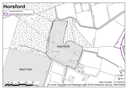
Bramley lakes, Dog Lane, Horsford |
GNLP0059 |
3.33 |
Range of uses (industrial, residential, commercial, recreation, leisure and tourism |
This site is not considered to be reasonable for allocation as access would be via an unadopted part of Dog Lane. An additional limiting factor is the capacity of the junction with Holt Road. There is no safe walking route to Horsford Primary School. |
|
|
||||
| (1) | ||||
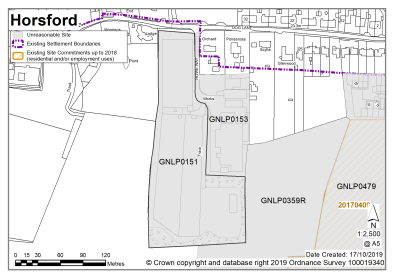
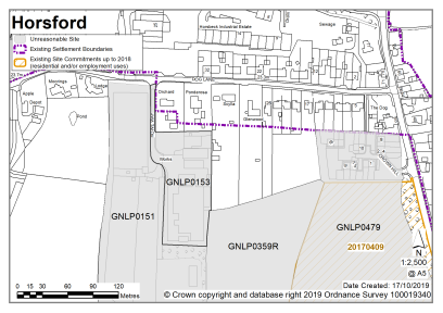
|
Pronto Joinery, Dog Lane, Horsford |
GNLP0151 |
2.34 |
Residential (unspecified number) |
This site is considered to be unreasonable due to highway constraints along Dog Lane. An additional limiting factor is the capacity of the junction with Holt Road. |
|
|
||||
| (1) | ||||
|
Pronto Joinery, Dog Lane, Horsford |
GNLP0153 |
0.85 |
Mixed Use (unspecified number) |
This site was considered worthy of further investigation due to its proximity to the existing built edge of the village, brownfield nature and the fact that it would fulfil the NPPF requirement for sites of 1ha or less. However, the site is considered to be unreasonable for allocation due to highway constraints along Dog Lane, the capacity of the junction with Holt Road and potential loss of existing commercial operations. |
|
|
||||
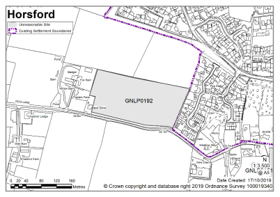
| (1) | ||||
|
Arable Land, Dog Lane, Horsford |
GNLP0192 |
2.66 |
Residential (unspecified number) |
This site is not considered to be reasonable for allocation as access would be via an unadopted part of Dog Lane. An additional limiting factor is the capacity of the junction with Holt Road. There is no safe route to Horsford Primary School. |
|
|
||||
|
Land to east of Brands Lane, Horsford, (partly in Drayton) |
GNLP0222 |
11.05 |
Light industrial and office uses, market and affordable housing including starter homes, live work and public open space |
This site is considered to be unreasonable for allocation as it is some distance from the built-up area of Horsford. It is closer to Thorpe Marriot but still separated from the built-up area by the Broadland Northway. Development here, of either a residential or commercial nature, would be remote and quite prominent in the landscape. There is no safe walking route to catchment schools in Horsford. Non catchment schools in Taverham or Drayton are closer but again with no safe walking route. |
|
|
||||
|
Land at 33 St Helena Way, Horsford |
GNLP0251 |
1.44 |
15-20 dwellings |
This site is not considered to be reasonable for allocation due to landscape/ecology and arboricultural issues. Trees to the southern boundary are likely to be a significant constraint and the woods to the north and west are a County Wildlife Site. Norfolk Wildlife Trust suggest that this site should also be designated as a County Wildlife Site highlighting the potential ecological significance. |
|
|
||||
| (2) | ||||
|
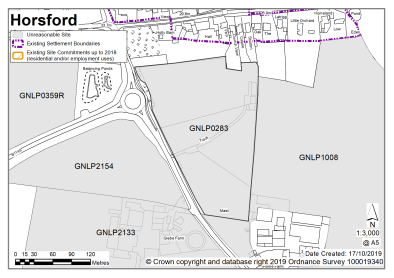
Land off Holt Road, Horsford |
GNLP0283 |
3.43 |
105 dwellings |
This site is not considered to be reasonable for allocation as it is separate from the built edge of the village and development here would be quite remote from the services and facilities in the main part of the village. There is no safe walking route to Horsford Primary School. |
|
|
||||
|
Land off Reepham Road, Horsford |
GNLP0302 |
7.34 |
150-200 dwellings |
This site is considered to be unreasonable for allocation as it some distance from the built-up area of Horsford, separated by the Broadland Northway. It is closer to Thorpe Marriot but still separated from the built-up area. Development here would be remote and potentially quite prominent in the landscape. There is no safe walking route to catchment schools in Horsford. Non catchment schools Taverham or Drayton are closer but again with no safe walking route. |
|
|
||||
| (2) | ||||
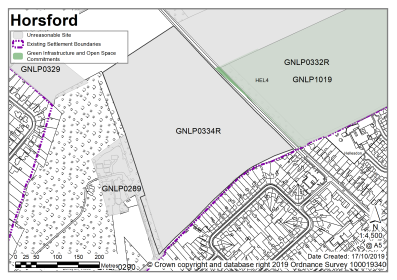
|
Reepham Road/ Cromer Road, Horsford |
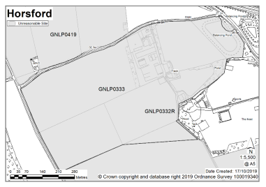
GNLP0332R |
64.00 |
600-700 dwellings |
This site was considered worthy of further investigation due to its location as an urban extension to Hellesdon. Development here would benefit from proximity to the extensive range of services and facilities in Hellesdon. However, the site raises potentially significant landscape issues given the scale of development and setting between the existing built edge and the Broadland Northway and it is therefore not considered to be reasonable for allocation. Noise and safety concerns with the airport are also critical. Surface water suds are unlikely to be allowed due to the potential to attract birds. |
|
|
||||
|
Reepham Road/Holt Road |
GNLP0333 |
36.60 |
Residential (unspecified number), improved cricket field, employment, roadside services and retail |
This site is considered to be unreasonable for allocation as it is some distance from the built-up area of Horsford, separated by the Broadland Northway. It is closer to Hellesdon or Drayton but still separated from the built-up area. Development here would be remote and have potential significant landscape impacts. There is no safe walking route to catchment schools in Horsford. Non-catchment schools in Hellesdon or Drayton may be closer but again with no safe walking route. |
|
|
||||
| (2) | ||||
|
West of Reepham Road, Horsford |
GNLP0334R |
11.70 |
250-300 dwellings |
This site was considered worthy of further investigation due to its location as an urban extension to Hellesdon. Development here would benefit from proximity to the extensive range of services and facilities in Hellesdon. However, the site is not considered to be reasonable for allocation as it would represent a significant expansion into the countryside and would impact on the character of Reepham Road. Noise and safety concerns linked with the airport are also critical. Surface water suds are unlikely to be allowed due to the potential to attract birds. Roadside trees may impact on achieving suitable access. |
|
|
||||
|
Land adjacent Drayton Lane, Horsford |
GNLP0359R |
8.10 |
Up to 150 dwellings |
This site is not considered to be reasonable for allocation as it is separate from the built edge of the village and development here would be quite remote from the services and facilities in the main part of the village. There is no safe walking route to Horsford Primary School. |
|
|
||||
| (1) | ||||
|
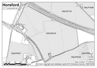
Land at Holly Lane/ Reepham Road, Horsford |
GNLP0419 |
40.65 |
Approx. 750 dwellings with associated access and open space |
This site is considered to be unreasonable for allocation as it is some distance from the built-up area of Horsford, separated by the Broadland Northway. It is closer to Hellesdon or Drayton but still separated from the built-up area. Development here would be remote and have potential significant landscape impacts. There is no safe walking route to catchment schools in Horsford. Non catchment schools in Hellesdon or Drayton may be closer but again with no safe walking route. |
|
|
||||
| (2) | ||||
|
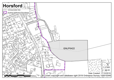
Land at Lodge Farm, Horsford |
GNLP0422 |
1.65 |
40 dwellings |
This site is not considered to be reasonable for allocation as it has convoluted access and it is not clear how the site would be accessed from the highway. The site could not accommodate the scale of development proposed. |
|
|
||||
| (1) | ||||
|
Land at Mill Lane, Horsford |
GNLP0423 |
0.95 |
10 dwellings |
This site is considered to be unreasonable as it is unlikely to meet the minimum 12-15 dwelling requirement for allocation and is already committed for development of 8 dwellings under planning application reference 20170707. |
|
|
||||
|
Land off St Helena Way, Horsford |
GNLP0469 |
2.64 |
Approx. 10-15 dwellings with remaining land available as open space |
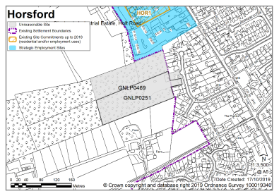
This site is considered to be unreasonable due to landscape/ecology and arboricultural issues. Trees to the southern boundary are likely to be a significant constraint and the woods to the north and west are a County Wildlife Site. Norfolk Wildlife Trust suggest that this site should also be designated as a County Wildlife Site highlighting the potential ecological significance. |
|
|
||||
| (1) | ||||
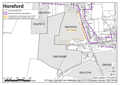
|
Land east of Holt Road, Horsford |
GNLP0479 |
4.38 |
Approx. 80 dwellings with open space, play equipment and GI |
This site is not considered to be suitable for allocation as despite being a reasonable location for development it already had planning permission at the base date of the plan in 2018 and is currently under construction. |
|
|
||||
| (1) | ||||
|
Land to the east of Holt Road, Horsford |
GNLP0519 |
15.59 |
Approx. 266 dwellings |
This site is not considered to be suitable for allocation as despite being a reasonable location for development it already had planning permission at the base date of the plan in 2018 and is currently under construction. |
|
|
||||
| (1) | ||||
|
Hilltop Farm, Church Street, Horsford |
GNLP0578 |
6.67 |
Residential (unspecified number) |
This site is not considered to be reasonable for allocation as it is separate from the built edge of the village and development here would be quite remote from the services and facilities in the main part of the village. |
|
|
||||
| (1) | ||||
|
Home Farm, Holt Road, Horsford |
GNLP1008 |
20.25 |
Residential (unspecified number) |
This site is not considered to be reasonable for allocation as it is separate from the built edge of the village and development here would be quite remote from the services and facilities in the main part of the village. There is no safe walking route to Horsford Primary School. The site as proposed is too large for the capacity of the cluster. |
|
|
||||
|
Dog Lane, Horsford |
GNLP1043 |
7.21 |
Residential (unspecified number) |
This site is not considered to be reasonable for allocation as access would be via an unadopted part of Dog Lane. An additional limiting factor is the capacity of the junction with Holt Road. There is no safe route to Horsford Primary School. |
|
|
||||
| (2) | ||||
|
Green Lane, Horsford |
GNLP2160 |
29.70 |
600 dwellings |
This site is not considered to be reasonable for allocation as the scale of the proposal is a concern with a lack of safe walking/cycling route to the catchment high school. Development would require highway improvements and it is unlikely that a satisfactory access strategy would be able to be developed for the entire level of development. There are also ongoing concerns with the new B1149 roundabout. Smaller areas of the larger site were considered but dismissed as unsuitable due to the standard of Mill Lane and Green Lane. |
|
|
||||
|
North of Reepham Road, Horsford |
GNLP3005 |
2.25 |
Residential (unspecified number) |
This site is considered to be unreasonable for allocation as it some distance from the built-up area of Horsford, separated by the Broadland Northway. It is closer to Thorpe Marriot but still separated from the built-up area. Development here would be remote and potentially quite prominent in the landscape. There is no safe walking route to catchment schools in Horsford. Non catchment schools Taverham or Drayton are closer but again with no safe walking route. |
|
|
||||
| (1) | ||||
|
Swanington Lane, Felthorpe |
GNLP2009 |
2.00 |
15-20 dwellings |
This site is not considered to be reasonable for allocation as it has poor access to core services and facilities in Horsford some distance away. In particular there is no safe walking route to Horsford Primary School which is over 3km away. |
|
|
||||
| (1) | ||||
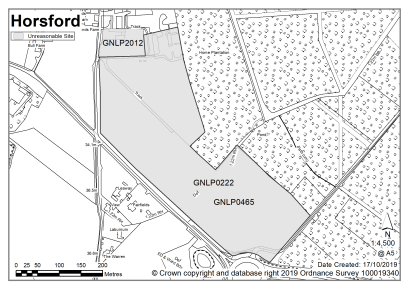
|
Brand's Lane, Felthorpe |
GNLP2012 |
0.63 |
5 dwellings |
This site is not considered to be reasonable for allocation as it has poor access to core services and facilities in Horsford some distance away. In particular there is no safe walking route to Horsford Primary School which is over 3km away. |
|
|
||||
|
North of Church Lane, Felthorpe |
GNLP3004 |
1.24 |
16 dwellings |
This site is not considered to be reasonable for allocation as it has poor access to core services and facilities in Horsford some distance away. In particular there is no safe walking route to Horsford Primary School which is over 3km away. |
|
|
||||

Unreasonable Sites – Non-Residential
|
Address |
Site Reference |
Area (ha) |
Promoted for |
Reason considered to be unreasonable |
|||||
|
Horsford, Felthorpe and Haveringland |
|||||||||
| (1) | |||||||||
|
Glebe Farm North, Horsford |
GNLP2133 |
26.23 |
Employment/mixed |
This site is not considered to be suitable for allocation as evidence suggests that currently committed land is more than sufficient in quantity and quality to meet the employment growth needs in Greater Norwich. There is therefore no need to allocate any additional large-scale employment sites in the new local plan. |
|||||
|
|
|||||||||
|
South of Drayton Lane, Horsford |
GNLP2154 |
2.30 |
Retail/car parking |
This site is promoted specifically for a supermarket with associated car parking. The site is not preferred for allocation as it is not within an accessible walking distance of Horsford and there is no evidence of an end user being in place to assure delivery of the scheme. |
|||||
|
|
|||||||||
The catchment of St. Faiths Primary School brings Horsham St Faith and Newton St Faith into a village cluster. St Faiths Primary School has some capacity. The site is not entirely 'landlocked' but the available land for expansion is very limited.
It is considered that as well as existing allocations and windfall development, approximately 20-50 new homes are appropriate for the Horsham and Newton St Faith cluster. Horsham St Faith and Newton St Faith contains a range of services including a primary school, village hall, food shop and public transport.
One site is identified as a preferred option, providing for between 20-30 new homes in the cluster. There is one carried forward residential allocation for 60 homes and a total of 15 additional dwellings with planning permission on small sites. This gives a total deliverable housing commitment for the cluster of between 95-105 homes between 2018 – 2038.
All new and carried forward allocations are expected to address standard requirements associated with development. These vary from place to place, but are likely to include mitigations for flood risk (as well as SUDs), highways improvements, safeguarding of minerals resources, land remediation, measures to protect the environment, biodiversity, and landscape intrusion.
|
POLICY GNLP0125 – Land west of West Lane, Horsham St Faith (approx. 1.44ha) is allocated for residential development. The site is likely to accommodate 20-30 homes, 33% of which will be affordable. More homes may be accommodated, subject to an acceptable design and layout, as well as infrastructure constraints.
The development will be expected to address the following specific matters:
|
Notes
GNLP0125: This site is proposed for allocation but for a smaller area than submitted to reflect the fact that there is limited capacity at St Faiths Primary School. The site has sensitivities relating to the nearby Conservation Area and Listed Buildings.
Existing allocation to be carried forward
|
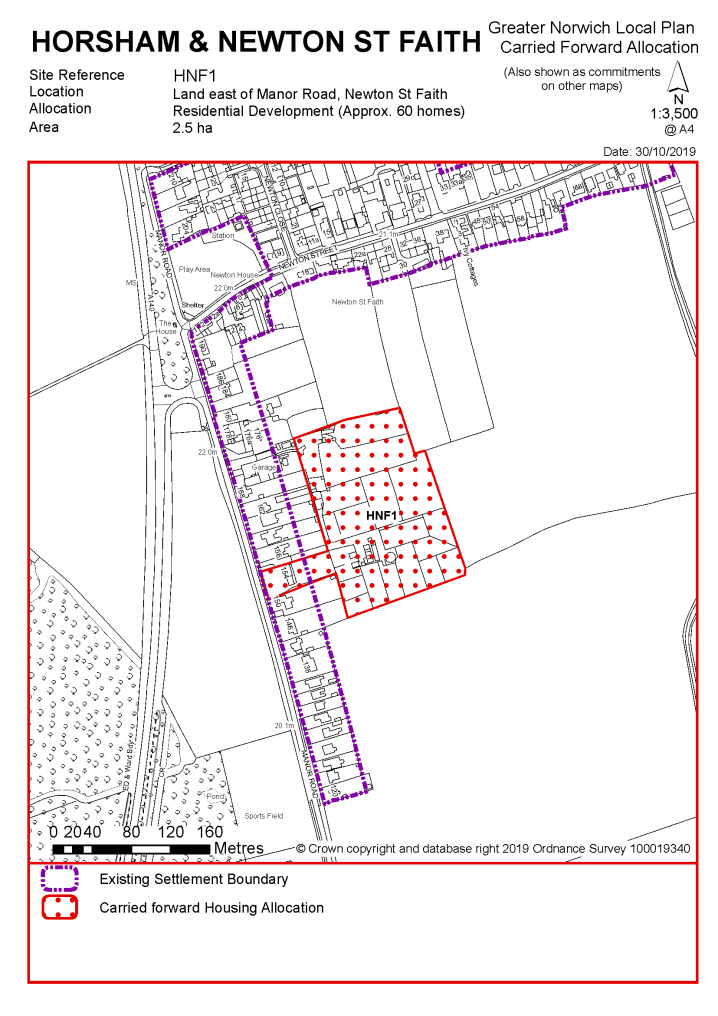
POLICY HNF1 Land east of Manor Road, Newton St Faith (approx. 2.5ha), is allocated for residential development. This will accommodate approximately 60 homes.
The development will be expected to address the following specific matters:
|
Notes
HNF1: This site was allocated in the 2016 local plan but has not yet been developed. The principle of development on the site has already been accepted and it is expected that development will take place within the time-period of this local plan up to 2038. The site is considered in the calculation of the housing requirement, providing at least 60 homes, but more may be accommodated, subject to an acceptable design and layout being achieved.
|
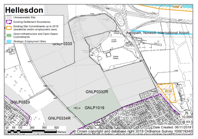
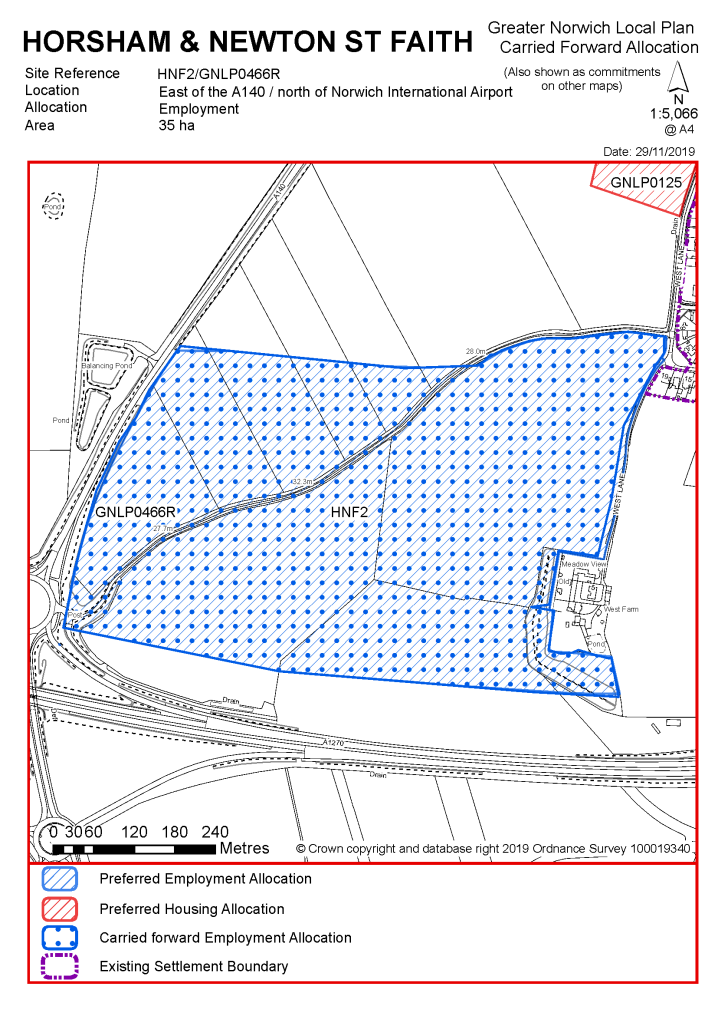
POLICY HNF2/ GNLP0466R Land east of the A140 and north of Norwich International Airport, Horsham St Faith (approx. 35ha) is allocated for employment uses. This will be to provide a full range of employment uses including for those benefitting from a location close to the airport.
It is expected:
The development will be expected to address the following specific matters:
|
Notes
HNF2: The site was allocated in 2016 as part of the local plan but has not yet been developed. The principle of development on the site has already been accepted and it is expected that development will take place within the new local plan time-period up to 2038. The site is re-allocated for employment/commercial development. The site has been promoted through the GNLP on a slightly larger boundary as site 0466R however it is not proposed to amend the existing allocation boundary at the current time. It is however proposed to amend the allocation policy to allow a full range of employment uses to come forward, including those benefitting from a location close to the airport.
|
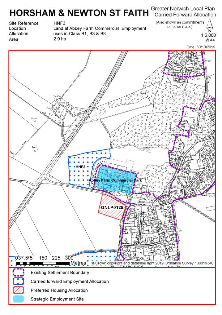
POLICY HNF3 Land at Abbey Farm Commercial, Horsham St Faith (approx. 2.9ha) is allocated for employment uses (Use Classes B1, B2, B8). The development will be expected to address the following specific matters:
|
Notes
HNF3: The site was allocated in 2016 as part of the local plan but has not yet been developed. The principle of development on the site has already been accepted and it is expected that development will take place within the new local plan time-period up to 2038. The site is re-allocated for employment/commercial development.
|
Address |
Site Reference |
Area (ha) |
Promoted for |
Comments |
|
Horsham & Newton St Faith |
||||
|
NO REASONABLE ALTERNATIVE SITES |
||||
Unreasonable Sites - Residential
|
Address |
Site Reference |
Area (ha) |
Promoted for |
Reason considered to be unreasonable |
|
Horsham & Newton St Faith |
||||
|
Poor piece, 80 Newton Street |
GNLP0085 |
0.75 |
Approx. 4 dwellings |
Although this site is well related to the form and character of the village adjacent to the existing settlement limit it is not considered to be reasonable for allocation as it unlikely to meet the minimum 12-15 dwelling allocation requirement as frontage development would be preferred. There are mature trees to the roadside, which add to the street scene and should be retained, which may also impact on the developable area. Part of the site already has planning permission for 4 dwellings. |
|
|
||||
|
Manor Road |
GNLP0246 |
0.78 |
Residential (unspecified number) |
This site is well related to the existing form and character of the village with a safe pedestrian route to St Faiths Primary School and minimal other constraints. It is not considered to be reasonable for allocation as it is unlikely to meet the minimum allocation threshold of 12-15 dwellings if developed at a similar density to reflect existing built form. |
|
|
||||
|
Land off West Lane |
GNLP0471 |
1.21 |
Approx. 15 dwellings |
This site is considered to be unreasonable for flood risk and highway reasons. There is an area of surface water flood risk which will affect the overall developable area and make it unlikely that the minimum 12-15 dwelling allocation requirement could be met. Access would be via West Lane which is a narrow unadopted road that is unlikely to be suitable for development traffic. |
|
|
||||
| (22) | ||||
|
Land east of Old Norwich Road |
GNLP0482 |
17.38 |
Approx. 70 dwellings as well as 8.95ha of green space |
This is a sizeable site which if developed in its entirety would be too large for the identified capacity of the cluster. The site is considered to be unreasonable for allocation as development in this location would be particularly prominent in the landscape. |
|
|
||||
| (5) | ||||
|
Land off Manor Road |
GNLP1054 |
5.50 |
Residential development extending the neighbouring allocation HNF1 |
This site is reasonably well related to the existing built form and character of the village, adjacent to the existing HNF1 allocation, with a safe pedestrian route to St Faiths Primary School. There is a section of surface water flood risk. The site is not considered to be reasonable for allocation due to landscape character and neighbour amenity issues. Current outline planning application 20181525 is under appeal against non-determination. |
|
|
||||
| (2) | ||||
|
Oak Tree Farm |
GNLP2021 |
10.83 |
Residential (unspecified number) |
This site is considered to be unreasonable for allocation as it is separated from the existing form and character of the village with resulting townscape and landscape implications. There is no safe walking route to St Faiths Primary School. |
|
|
||||
| (2) | ||||
|
The Warren |
GNLP2030 |
1.65 |
Residential (unspecified number) |
This site is considered to be unreasonable for flood risk reasons. The site is almost wholly covered by surface water flood risk which would affect the developable area. The site also appears to be covered by a large number of mature trees. |
|
|
||||
| (3) | ||||
|
Manor Road/ A140 Cromer Road |
GNLP2141 |
2.63 |
20-40 dwellings |
This site has a safe pedestrian route to St Faiths Primary School. However, the site is not considered to be reasonable for allocation as it would be very prominent when viewed from the A140 and traffic noise would be an issue. Development in this location would extend residential development west of Manor Road contrary to the existing settlement pattern and would be out of keeping with the form and character of the village. |
|
|
||||
| (6) | ||||
|
East of Manor Road |
GNLP3027 |
2.63 |
25-50 dwellings |
This site is considered to be unreasonable for allocation for flood risk reasons. The site is almost wholly covered by surface water flood risk which would affect the developable area. |
|
|
||||
| (8) | ||||
|
North of Meadow Farm Lane |
GNLP3028 |
1.95 |
25-50 dwellings |
This site is considered to be unreasonable for allocation as vehicular access would be from narrow roads and there is no safe walking route to St Faiths Primary School. |
|
|
||||
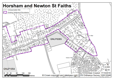
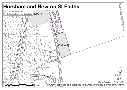
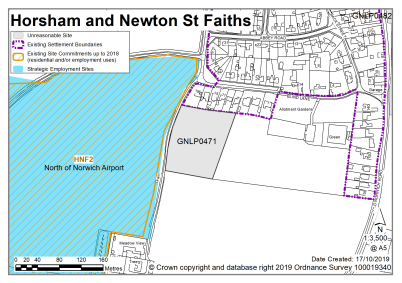
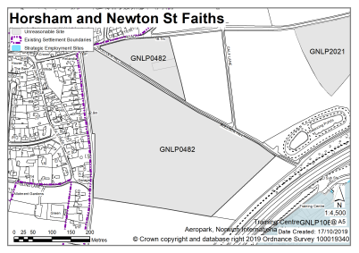
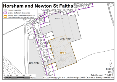
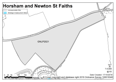
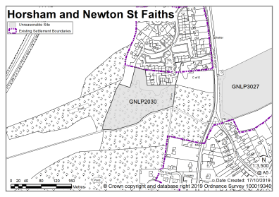
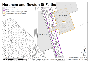
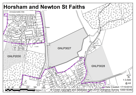
LINGWOOD AND BURLINGHAM, STRUMPSHAW AND BEIGHTON
The catchment area of Lingwood Primary School brings Lingwood and Burlingham, together with Beighton and Strumpshaw into a village cluster. Space at Lingwood Primary School is forecast to be taken up in future years but as well as windfall development, Norfolk County Council (as education authority) would accept development in the order of 50-60 new homes. The cluster has a range of facilities including a primary school, village hall, recreation land, food shop and access to public transport (including a train station).
Consequently, one site is identified as a preferred option, providing for between 50-60 new homes in the cluster. There are no carried forward residential allocations but there is a total of 44 additional dwellings with planning permission on small sites. This gives a total deliverable housing commitment for the cluster of between 94 – 104 homes between 2018 – 2038.
Strumpshaw has a made neighbourhood plan which covers the same area as that of the parish boundary. The Plan was made in July 2014 and covers the period to 2026. It contains a series of policies that look to shape development within the neighbourhood area. There are policies within the plan that will be of relevance to development and any applications that are submitted for development within the parish should have due regard to those policies.
All new and carried forward allocations are expected to address standard requirements associated with development. These vary from place to place, but are likely to include mitigations for flood risk (as well as SUDs), highways improvements, safeguarding of minerals resources, land remediation, measures to protect the environment, biodiversity, and landscape intrusion.
|
POLICY GNLP0379 Land north of Post Office Road, Lingwood (approx. 4.74ha) is allocated for residential development, including a large area of open space. The site is likely to accommodate 50-60 homes, 33% of which will be affordable. More homes may be accommodated, subject to an acceptable design and layout being achieved.
The development will be expected to address the following specific matters:
|
Notes
GNLP0379: This site is proposed for allocation but over a larger area than submitted. This larger allocation would enable open space to be provided to mitigate impact on the nearby Grade I Listed Church, potentially in the form of a linear parkland to the north. The site is centrally located in the village, adjacent to the existing settlement limit and has a safe walking route to Lingwood Primary School. A larger site, along the whole road frontage, would enable road widening to an acceptable standard and encourage a reduction in vehicle speeds.
(3) No existing allocations to be carried forward
|
Address |
Site Reference |
Area (ha) |
Promoted for |
Comments |
|
Lingwood and Burlingham, Beighton and Strumpshaw |
||||
| (11) | ||||
|
Land east of Buckenham Lane and west of Buckenham Road |
GNLP0296 |
3.60 |
Approx. 110 dwellings |
This site is considered to be a reasonable alternative as it is well located in relation to the form and character of Lingwood with the possibility of vehicular access from Buckenham Road. There is an area of surface water flood risk to the south west of the site which may limit the developable area. The site is not preferred for allocation as there is considered to be a better site in Lingwood to meet the capacity of the cluster. |
| (20) | ||||
|
Land west of Blofield Road |
GNLP0380 |
0.91 |
Approx. 30 dwellings |
This site is considered to be a reasonable alternative as it would act as a gateway site into the village creating a sense of place although some mature trees may need to be removed to facilitate visibility in/out of the site. The site is not preferred for allocation as there is considered to be a better site in Lingwood to meet the capacity of the cluster. |
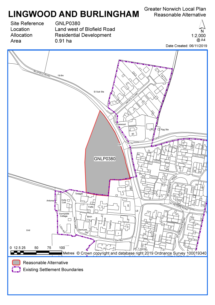
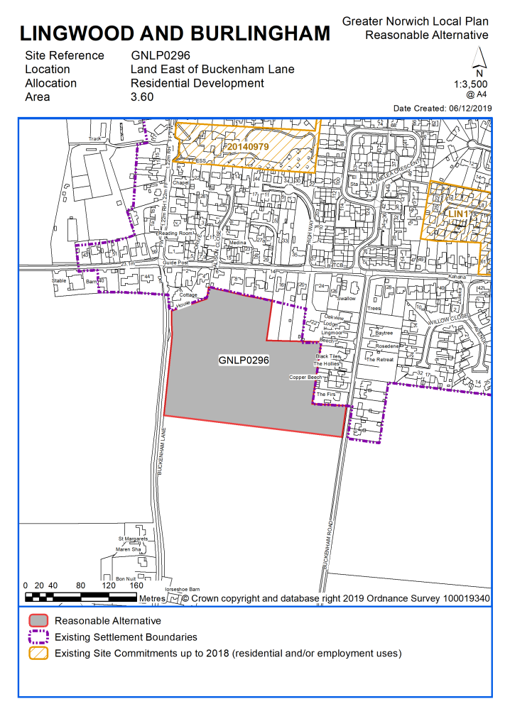
Unreasonable Sites - Residential
|
Address |
Site Reference |
Area (ha) |
Promoted for |
Reason considered to be unreasonable |
|
Lingwood and Burlingham, Beighton and Strumpshaw |
||||
| (2) | ||||
|
Land at Lodge Road, Lingwood |
GNLP0067 |
1.97 |
Mixed use development comprising office, café, meeting rooms and up to 15 live/work units |
This site is located at the extreme north-eastern edge of the settlement with some surface water flood risk. The proposal is to expand the existing planning permission given on appeal from 7 to 15 live work units and offices which to date has not been delivered. If a high level of demand arises for these types of units then this could be considered through a new planning application but there is no current evidence of need to warrant allocation of the site for the proposed uses. Access into the village would be along a relatively busy road without footways therefore there is no safe walking route to Lingwood Primary School. |
|
|
||||
| (36) | ||||
|
23 Norwich Road, Strumpshaw |
GNLP0090 |
0.85 |
Residential (unspecified number) |
This site is centrally located within Strumpshaw but access to facilities in Lingwood, including the school would be along Norwich Road which is relatively busy without footways until the edge of the village after the Huntsman Public House. There is a substantial area of surface water flood risk to the north of the site and it is identified as a key green feature to be protected in the Strumpshaw Neighbourhood Plan. |
|
|
||||
| (39) | ||||
|
Land to the north of Long Lane, Strumpshaw |
GNLP0215 |
16.09 |
5-25 dwellings |
This is a very large site located to the west of the Strumpshaw which if developed in its entirety would be contrary to the form and character of the village. The site is some distance from the main facilities in Lingwood, including the school, with only intermittent footways along Norwich Road. There is conflict with the Strumpshaw Neighbourhood Plan which seeks to protect the gap between Strumpshaw and Brundall. |
|
|
||||
| (5) | ||||
|
Land at Southwood Road/Hantons Loke, Beighton |
GNLP0449 |
2.17 |
Approx. 36 dwellings |
This site is considered to be unreasonable for allocation as it is poorly located to access facilities in Lingwood or elsewhere, in terms of distance and lack of footways. There is no safe pedestrian route to Lingwood Primary School. There are few facilities available in Beighton itself which has no settlement limit. |
|
|
||||
| (1) | ||||
|
Land to the north of Lodge Lane, Lingwood |
GNLP0499 |
2.91 |
Approx. 30 dwellings |
This site is considered to be unreasonable as it is divorced from the existing settlement and would appear as a separate enclave if developed contrary to the form and character of the village. Access into the village would be along a relatively busy road without footways therefore there is no safe walking route to Lingwood Primary School. |
|
|
||||
| (34) | ||||
|
Mill Lane (South of Norwich Road, North of Buckenham Road), Strumpshaw |
GNLP0521 |
3.05 |
Approx. 90 dwellings |
This site is located to the south of Strumpshaw, divorced from the settlement and distant from the main facilities in Lingwood including the school with no safe pedestrian route. Vehicular access is down a narrow road which is unlikely to be acceptable in highway terms. |
|
|
||||
| (38) | ||||
|
Mill Road, Strumpshaw |
GNLP2017 |
3.78 |
Residential (unspecified number) |
This site is located to the south of Strumpshaw, divorced from the settlement and distant from the main facilities in Lingwood including the school with no safe pedestrian route. Vehicular access is down a narrow road which is unlikely to be acceptable in highway terms. |
|
|
||||
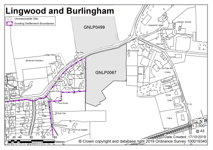
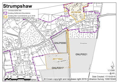
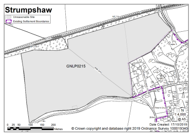
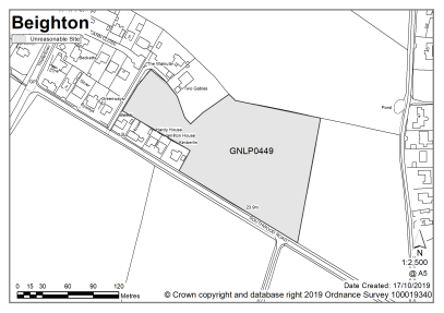
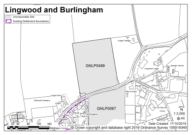
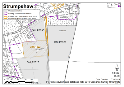
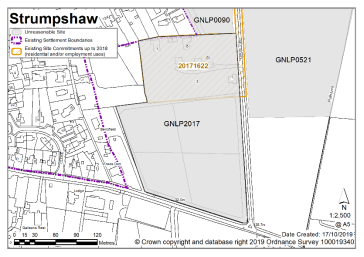
Marsham is not clustered with other settlements as the school catchment does not extend to adjoining villages. The school currently has spare capacity. Alongside the primary school, Marsham has a village hall and pub.
It is considered that as well as existing allocations, approximately 50-60 new homes are appropriate for the settlement. The new proposed allocation does not amount to this figure; however, further development is not ruled out. Windfall development policy 7.4 allows an amount of growth in each village cluster that reflects primary school capacity.
One site is identified as a preferred option, providing for between 25-35 new homes in the cluster. There are no carried forward residential allocations but there is a total of 20 additional dwellings with planning permission on small sites. This gives a total deliverable housing commitment for the cluster of between 45-55 homes between 2018 – 2038.
All new and carried forward allocations are expected to address standard requirements associated with development. These vary from place to place, but are likely to include mitigations for flood risk (as well as SUDs), highways improvements, safeguarding of minerals resources, land remediation, measures to protect the environment, biodiversity, and landscape intrusion.
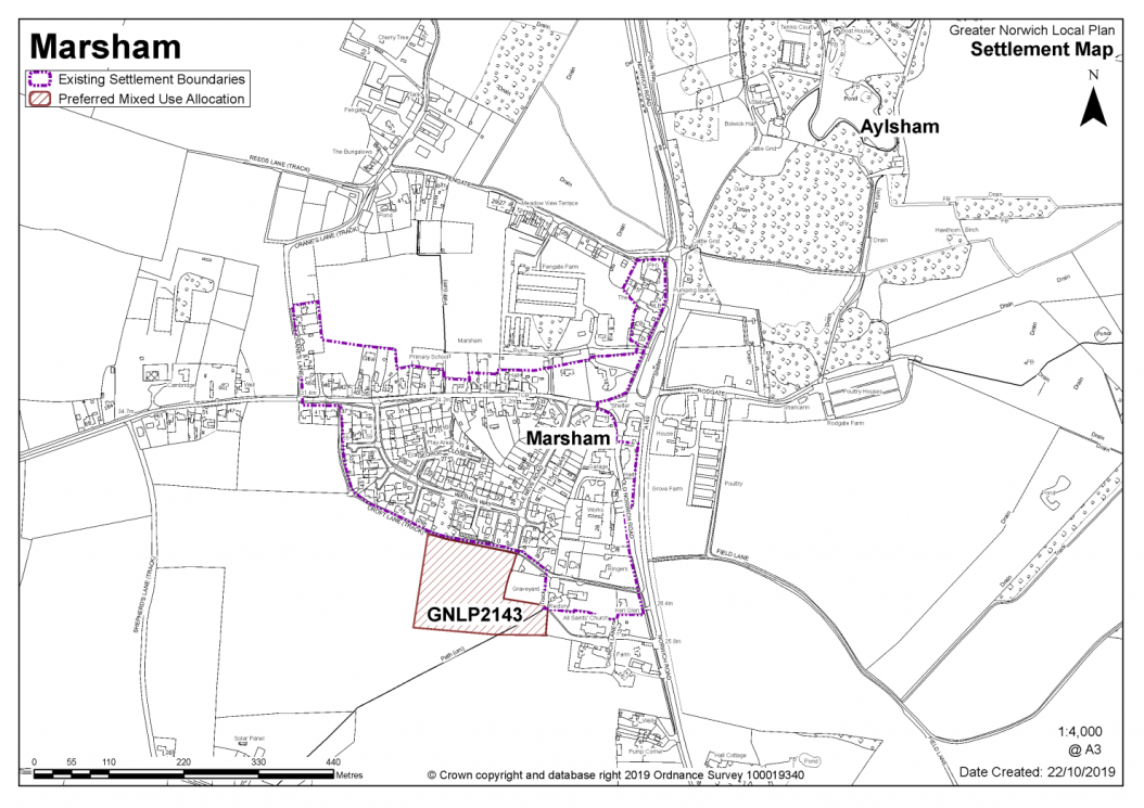
|
GNLP2143 - Land south of Le Neve Road, Marsham (approx. 1.97 ha) is allocated for residential development and extension to cemetery at All Saint Church. The site is likely to accommodate 25-35 homes, 33% of which will be affordable. More homes may be accommodated, subject to an acceptable design and layout, as well as infrastructure constraints. The development will be expected to address the following specific matters:
|
Notes GNLP2143: This is the only site considered suitable for allocation in Marsham. It is allocated subject to vehicular access via Le Neve Road. Development will need to respect the setting of the adjacent Grade I listed church and provide an extension to the cemetery if required.
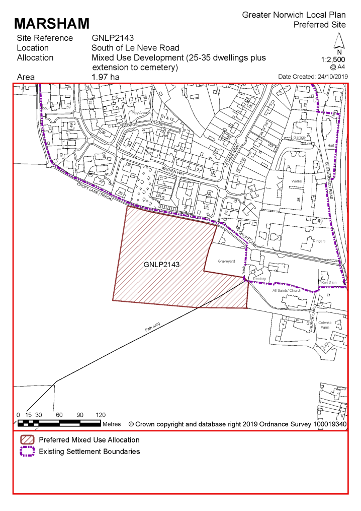
No existing allocations to be carried forward
|
Address |
Site Reference |
Area (ha) |
Promoted for |
Comments |
|
Marsham |
||||
|
NO REASONABLE ALTERNATIVE SITES |
||||
Unreasonable Sites - Residential
|
Address |
Site Reference |
Area (ha) |
Promoted for |
Reason considered to be unreasonable |
|
Marsham |
||||
|
Land to rear of 40-46 High Street |
GNLP0171 |
1.71 |
Residential (unspecified number) including open space, landscaping & associated infrastructure |
This site is located to the north of the village, with poor access along Fengate and/or Cranes Lane, which are single track country lanes with no footway provision to Marsham Primary School 250m. The site does back onto a permitted scheme for 8 dwellings off the High Street but there is no vehicular access available through this scheme. |
|
|
||||
|
Former Piggeries, Fengate Farm |
GNLP0219 |
1.78 |
Approx. 25 dwellings |
This site is located to the north of the village, with poor access along Fengate and/or Cranes Lane, which are single track country lanes with no footway provision to Marsham Primary School. |
|
|
||||
|
Land North, East, West and South of Marsham |
GNLP0229 |
63.42 |
Approx. 1000 dwellings, public open space, community facilities, retail, commercial development land for school extension if required |
This is a very large development proposal which if developed in its entirety would be out of keeping with the form and character of Marsham and would total far more dwellings than is sought in the village cluster. Consideration has been given to whether smaller sections of the larger site could be brought forward and the frontage sections on the north and south side of the High Street would seem to have the most potential. After careful consideration none of the site is thought to be reasonable for allocation due to highway constraints on The Street and the fact that all traffic from the development would have to travel via The Street to access the A140. |
|
|
||||
|
Fengate Farm |
GNLP0572 |
0.70 |
10-12 dwellings |
This site is located to the north of the village, with poor access along Fengate and/or Cranes Lane, which are single track country lanes with no footpath provision to Marsham Primary School. |
|
|
||||
| (2) | ||||
|
Fengate Farm, Fengate |
GNLP3035 |
3.06 |
35 dwellings |
This former piggeries site is well located in relation to the form and character of the settlement and was considered to be worthy of further investigation due to the benefits of redeveloping previously used land rather than a greenfield site. However, after careful consideration it is considered unreasonable for allocation as there has been a history of planning refusals in terms of access, visual impact and residential amenity. The site is not acceptable in highway terms as Fengate Lane is not of a sufficient standard to accommodate development traffic and the junction with the A140 poses a safety concern. The footway connection to Marsham Primary School is not continuous and it is not possible to improve this within the constraints of the highway. |
|
|
||||
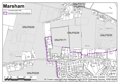
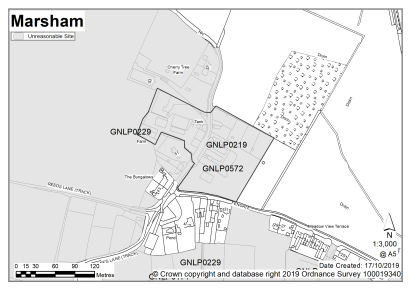
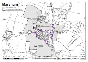
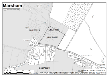
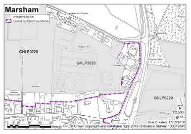
Reedham is not clustered with other settlements as the school catchment does not extend to adjoining villages. The school currently has spare capacity.
It is considered that as well as existing allocations and windfall development, approximately 50-60 new homes are appropriate for Reedham. As well as the primary school, Reedham has a range of facilities that includes a food shop, pub, village hall, church, and public transport.
Two sites are identified as preferred options, providing for between 40-60 new homes in the cluster. There are no carried forward residential allocations but there is a total of 28 additional dwellings with planning permission on small sites. This gives a total deliverable housing commitment for the cluster of between 68-88 homes between 2018 – 2038.
Reedham has a neighbourhood area designated and the parish council is working on an emerging Neighbourhood Plan (at time of writing). Any applications that are submitted for development within the parish should take into account the emerging neighbourhood Plan for the area, in line with paragraph 48 of the National Planning Policy Framework).
All new and carried forward allocations are expected to address standard requirements associated with development. These vary from place to place, but are likely to include mitigations for flood risk (as well as SUDs), highways improvements, safeguarding of minerals resources, land remediation, measures to protect the environment, biodiversity, and landscape intrusion.
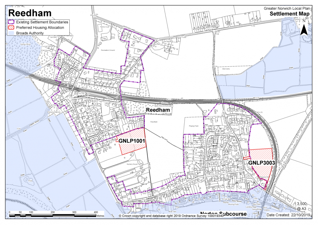
|
POLICY GNLP1001 Land to East of Station Road, Reedham (approx. 1.10Ha) is allocated for residential development. The site is likely to accommodate 20-30 homes, 33% of which will be affordable. More homes may be accommodated, subject to an acceptable design and layout as well as infrastructure constraints. The development will be expected to address the following specific matters:
|
Notes
GNLP1001: This site is preferred for allocation as it has minimal constraints. However, it is accepted that it is not possible to provide an off-carriageway pedestrian footway for the whole route to Reedham Primary School. The site can be allocated subject to vehicular access via adjacent existing Broadland Local Plan site allocation RED1 and footpath connection with Public Rights of Way at the north and east boundaries of the site.
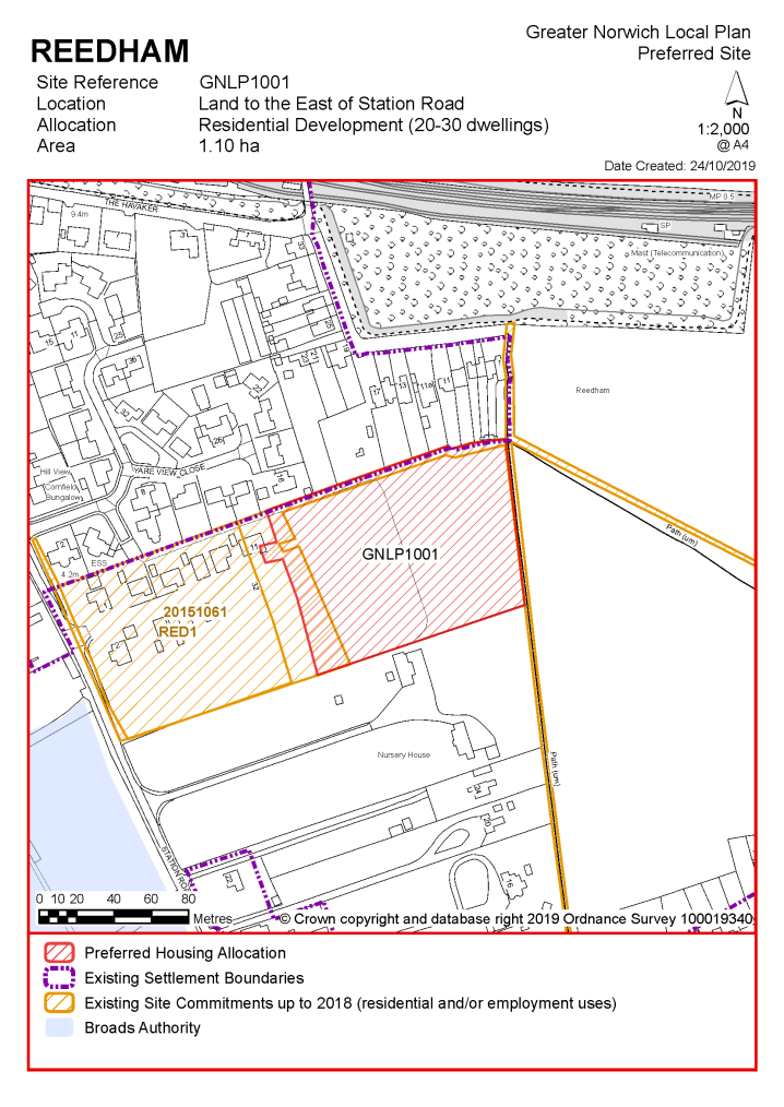
|
POLICY GNLP3003: Mill Road, Reedham (approx. 1.30Ha) is allocated for residential development. The site is likely to accommodate 20-30 homes, 33% of which will be affordable. More homes may be accommodated, subject to an acceptable design and layout as well as infrastructure constraints. The development will be expected to address the following specific matters:
|
|
Notes
|
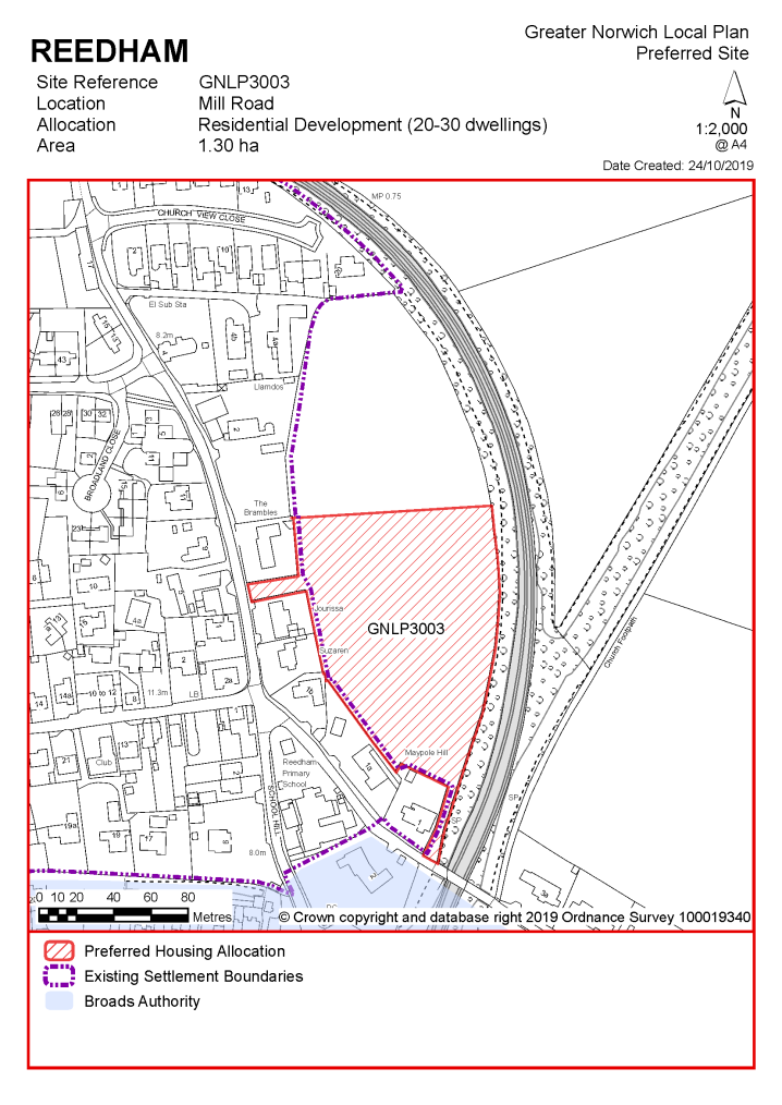
(3) No existing allocations to be carried forward.
|
Site Reference |
Area (ha) |
Promoted for |
Comments |
|
|
Reedham |
||||
|
NO REASONABLE ALTERNATIVE SITES |
||||
|
Address |
Site Reference |
Area (ha) |
Promoted for |
Reason considered to be unreasonable |
|
Reedham |
||||
|
NO UNREASONABLE SITES |
||||
SALHOUSE, WOODBASTWICK AND RANWORTH
The catchment of Salhouse Primary School brings Salhouse, Woodbastwick and Ranworth into a village cluster. The school is at capacity though expansion opportunities are likely. Salhouse has a range of facilities including a primary school, pub and village hall.
It is considered that as well as existing allocations and windfall development, approximately 20-50 new homes are appropriate for the Salhouse cluster. The proposed new allocation does not amount to this figure; however, further development is not ruled out. Windfall development policy 7.4 allows an amount of growth in each village cluster that reflects primary school capacity.
One site is identified as a preferred option, providing for between 12-15 new homes in the cluster. There are no carried forward residential allocations but there is a total of 11 additional dwellings with planning permission on small sites. This gives a total deliverable housing commitment for the cluster of between 23-26 homes between 2018 – 2038.
Salhouse has a made neighbourhood plan which covers the same area as that of the parish boundary. The Plan was made in July 2017 and covers the period to 2026. It contains a series of policies that look to shape development within the neighbourhood area. There are policies within the plan that will be of relevance to development and any applications that are submitted for development within the parish should have due regard to those policies.
All new and carried forward allocations are expected to address standard requirements associated with development. These vary from place to place, but are likely to include mitigations for flood risk (as well as SUDs), highways improvements, safeguarding of minerals resources, land remediation, measures to protect the environment, biodiversity, and landscape intrusion.
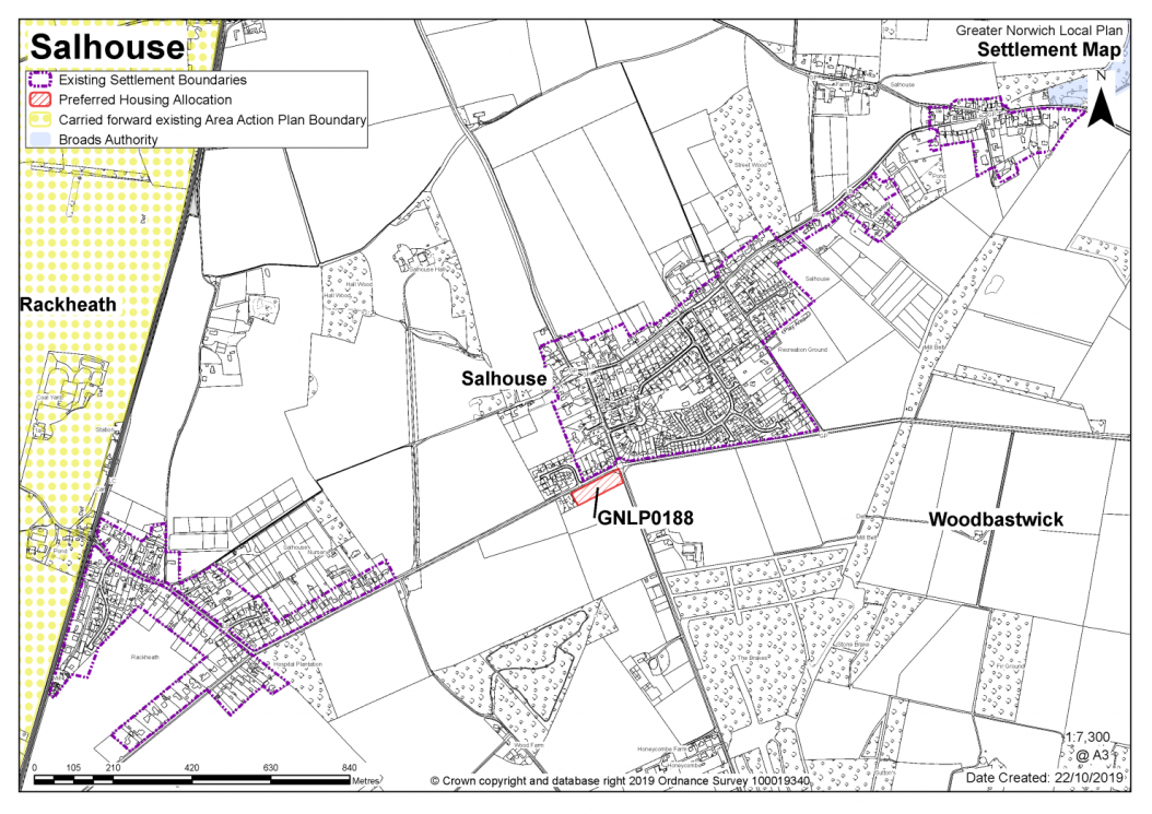
|
POLICY GNLP0188 – Land adjoining Norwich Road, Salhouse (approx. 0.52ha) is allocated for residential development. The site is likely to accommodate 12 - 15 homes, 33% of which will be affordable. More homes may be accommodated, subject to an acceptable design and layout as well as infrastructure constraints.
The development will be expected to address the following specific matters:
|
Notes
GNLP0188: This is the only site considered suitable for allocation in Salhouse, as other sites have been rejected due to significant landscape and heritage issues, including the setting of Salhouse Hall and the Grade I listed All Saints Church. This site will need a sensitive design and layout and as a consequence will only be able to accommodate a maximum of 12 - 15 dwellings.
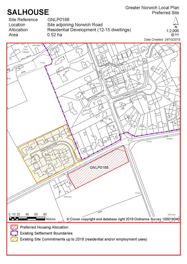
No existing allocations to be carried forward
Reasonable Alternatives - Residential
|
Address |
Site Reference |
Area (ha) |
Promoted for |
Comments |
|
Salhouse, Woodbastwick and Ranworth |
||||
|
NO REASONABLE ALTERNATIVE SITES |
||||
Reasonable Alternatives - Non-Residential
|
Address |
Site Reference |
Area (Ha) |
Proposal |
Reason for not allocating |
|||||
|
Salhouse |
|||||||||
| (1) | |||||||||
|
Land to the north of Salhouse Road, Salhouse |
GNLP0157 |
22.51 |
Tourism |
This site is considered to be a reasonable alternative as Salhouse Broad is already a visitor attraction for sailing, canoeing, walking and camping. It is not preferred for allocation at the current time as further information is required regarding the need for the proposal and exactly what is planned for the site. Note: The site is also partially within the Broads Authority administrative area. |
|||||
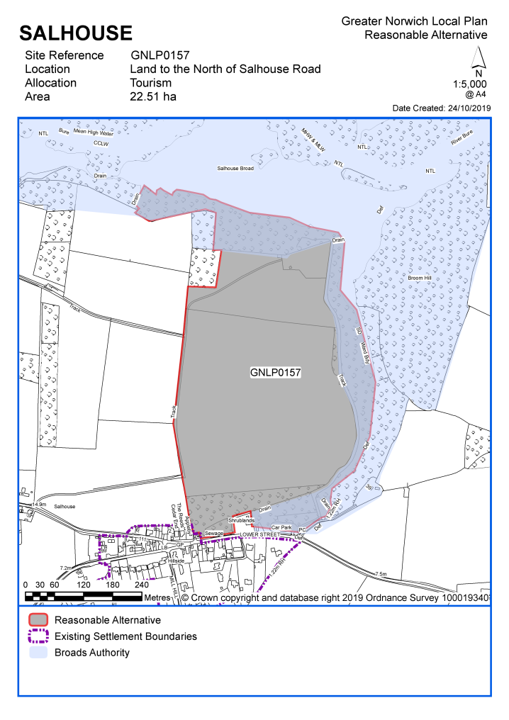
Unreasonable Sites - Residential
|
Address |
Site Reference |
Area (ha) |
Promoted for |
Reason considered to be unreasonable |
|
Salhouse, Woodbastwick and Ranworth |
||||
|
Land to the south of Stonehouse Road |
GNLP0160 |
15.59 |
Residential (unspecified number) |
This site is considered to be unreasonable for allocation as development here would not be well related to the form and character of the settlement. The site is disconnected from the village with an absence of footways therefore no safe walking route can be provided to Salhouse Primary School. |
|
|
||||
|
Land to the west of Bell Lane and to the north of Hall Drive |
GNLP0161 |
9.92 |
Residential (unspecified number) |
This site is not considered suitable for allocation as development would have significant landscape and heritage impacts, including the setting of Grade I listed church, Grade II listed war memorial and Grade II listed Salhouse Hall. The Church of All Saints is isolated from the village on a visible high point being prominent within views, particularly from Bell Lane where it is viewed with its rural context and setting. The site also abuts the historic parkland setting of Salhouse Hall. |
|
|
||||
|
Land to the north of Norwich Road |
GNLP0163 |
9.99 |
Residential (unspecified number) |
This site is not considered suitable for allocation as development would have significant landscape and heritage impacts. Development here would extend the built form further to the west closing the gap between the two parts of Salhouse. The site is within the Conservation Area and covers the original parkland of Salhouse Hall. Development either side of the hall access would result in considerable harm to the setting of the heritage asset. |
|
|
||||
|
Land to the north of Norwich Road |
GNLP0164 |
5.74 |
Residential (unspecified number) |
This site is considered to be unreasonable for allocation as development here would not be well related to the form and character of the settlement. The site is disconnected from the village with an absence of footways therefore no safe walking route can be provided to Salhouse Primary School. |
|
|
||||
| (1) | ||||
|
Site off Bell Lane |
GNLP0175 |
3.91 |
Residential (unspecified number) |
This site is not considered suitable for allocation as development would have significant landscape and heritage impacts. Development here would extend the built form of the village further northwards into open countryside at an important approach point to the village. Development would also be harmful to the setting of a number of heritage assets along Lower Street, particularly the Grade II listed Grange which is the oldest building in the village apart from the church and the interior of Salhouse Hall. |
|
|
||||
| (1) | ||||
|
Site off Lower Street |
GNLP0189 |
4.56 |
Residential (unspecified number) |
This site is not considered suitable for allocation as development would have significant landscape and heritage impacts. This is an important area of undeveloped land within the Conservation Area with a sloping gradient south to north and a sharp bank on the north side of Lower Street where rural character has been retained. Because of the sloping nature of the land development in this location would have a significant impact on the character and appearance of the Conservation Area transforming it into a more urban environment. |
|
|
||||
| (1) | ||||
|
Manor Farm, Land to the west of Wroxham Road (A1151) |
GNLP0226 |
30.55 |
Approx. 1000 dwellings |
This site is promoted as a long-term extension to the large scale Growth Triangle Area Action Plan (AAP) allocation at Rackheath and is not needed for development at the current time. Development of this site without completion of the AAP allocation would lead to an isolated and disconnected form of development in the countryside. There is no safe walking route to Salhouse Primary School. |
|
|
||||
| (2) | ||||
|
Land to the north of Norwich Road |
GNLP0487 |
11.38 |
86 dwellings and 6.37ha of GI |
This site is considered to be unreasonable for allocation as development here would not be well related to the form and character of the settlement. The site is disconnected from the village with an absence of footways therefore no safe walking route can be provided to Salhouse Primary School. |
|
|
||||
|
Land south of Norwich Road |
GNLP0493 |
9.26 |
86 dwellings and 5.09ha of GI |
This site is considered to be unreasonable for allocation as development here would not be well related to the form and character of the settlement. The site is disconnected from the village with an absence of footways therefore no safe walking route can be provided to Salhouse Primary School. |
|
|
||||
|
Land to the east of Panxworth Church Road & B1140, Woodbastwick |
GNLP0110 |
2.93 |
8-10 dwellings with associated landscaping and infrastructure |
This site is considered to be unreasonable for allocation as it is remote from services and facilities in Salhouse. Development here would not be well related to the form and character of the settlement and there is no safe walking route to Salhouse Primary School which is over 4km away. It is recognised that non-catchment schools in Blofield Heath or South Walsham may be closer, but these are still some 2km away with no safe walking route. |
|
|
||||
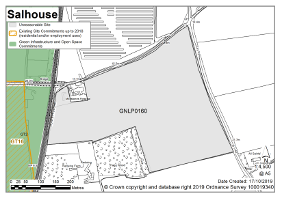
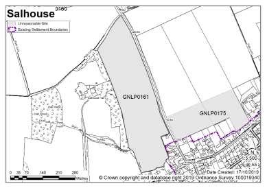
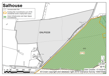
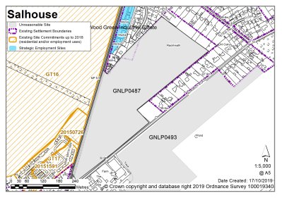
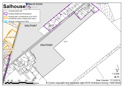
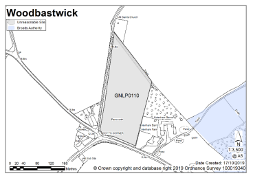
SOUTH WALSHAM AND UPTON-WITH-FISHLEY
South Walsham's Fairhaven Primary School brings together South Walsham and Upton with Fishley into a village cluster. The school currently has limited capacity.
It is considered that as well as existing allocations and windfall development, approximately 12-20 new homes are appropriate for the South Walsham cluster. The cluster has a range of facilities including a primary school, village hall, recreation land, public house, and access to public transport, but no food store.
One site is identified as a preferred option, providing for between 20-25 new homes in the cluster. There is one carried forward residential allocation for 20 homes and a total of 5 additional dwellings with planning permission on small sites. This gives a total deliverable housing commitment for the cluster of between 45-50 homes between 2018 – 2038.
All new and carried forward allocations are expected to address standard requirements associated with development. These vary from place to place, but are likely to include mitigations for flood risk (as well as SUDs), highways improvements, safeguarding of minerals resources, land remediation, measures to protect the environment, biodiversity, and landscape intrusion.
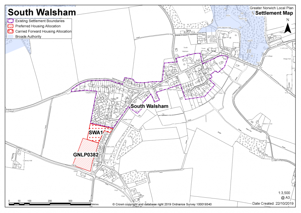
|
POLICY GNLP0382 – Land north of Chamery Hall Lane, South Walsham (approx. 1.21ha) is allocated for residential development. The site is likely to accommodate 20-25 homes, 33% of which will be affordable. More homes may be accommodated, subject to an acceptable design and layout as well as infrastructure constraints.
The development will be expected to address the following specific matters:
|
Notes
GNLP0382: This is the only site promoted in South Walsham. It has minimal constraints and is preferred for allocation subject to highway improvements to ensure a safe and continuous pedestrian route to Fairhaven Primary School.
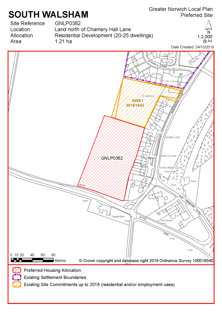
Existing allocation to be carried forward
|
POLICY SWA1 Land to the rear of Burlingham Road/St Marys Close, South Walsham (of approx. 0.6ha) is allocated for residential development. This will accommodate at least 20 homes. More homes may be accommodated, subject to an acceptable design and layout being achieved. The development will be expected to address the following specific matters:
|
Notes
SWA1: The site was allocated in the 2016 local plan but has not yet been developed. The principle of development on the site has already been accepted and it is expected that development will take place within the time-period of this local plan up to 2038, reflecting planning permission given on site (20161643). The site is considered in the calculation of the housing requirement, providing for 20 homes.
Adjacent land is proposed to be allocated for a further 20-25 new homes and both sites should be masterplanned together to bring forward a cohesive development.
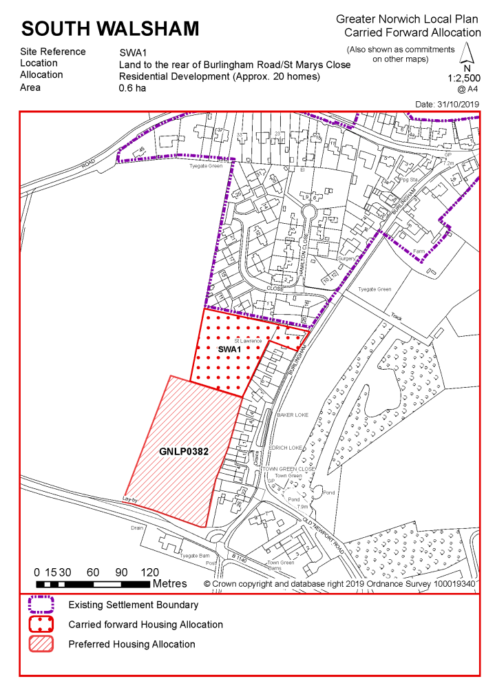
|
Address |
Site Reference |
Area (ha) |
Promoted for |
Comments |
|
South Walsham and Upton with Fishley |
||||
|
NO REASONABLE ALTERNATIVE SITES |
||||
|
Address |
Site Reference |
Area (ha) |
Promoted for |
Reason considered to be unreasonable |
|
South Walsham and Upton with Fishley |
||||
|
NO UNREASONABLE SITES |
||||
The catchment of Spixworth Infant School brings Spixworth and Crostwick into a village cluster. The school has limited capacity. The site is landlocked, but there may potentially be expansion opportunities. In addition to the school, services include a shop, doctor's surgery, village hall and public house.
Whilst it is considered the cluster could accommodate development of 20-50 additional homes, there are currently no new allocations proposed and no allocations to be carried forward in this cluster. There are however 27 dwellings with planning permission on small sites. No new allocations are proposed but further development is not ruled out. Windfall development policy 7.4 allows an amount of growth in each village cluster that reflects primary school capacity. See settlement map for the extent of existing settlement limits.
Spixworth has a neighbourhood area designated and the parish council is working on an emerging Neighbourhood Plan (at time of writing). Any applications that are submitted for development within the parish should take into account the emerging neighbourhood Plan for the area, in line with paragraph 48 of the National Planning Policy Framework').
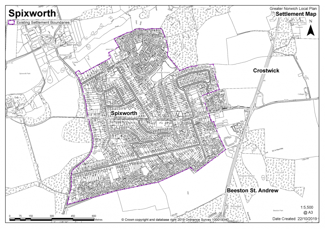
No existing allocations to be carried forward
|
Address |
Site Reference |
Area (ha) |
Promoted for |
Comments |
|
Spixworth and Crostwick |
||||
|
NO REASONABLE ALTERNATIVE SITES |
||||
Unreasonable Sites - Residential
|
Address |
Site Reference |
Area (ha) |
Promoted for |
Reason considered to be unreasonable |
|
Spixworth and Crostwick |
||||
| (1) | ||||
|
Land off North Walsham Road |
GNLP0467 |
6.20 |
100 dwellings |
This the only site promoted in the cluster but it is not considered to be reasonable for allocation as direct vehicular access onto the B1150 would lead to a form of development which is disconnected from the rest of the village. In addition, it does not seem possible to provide a safe pedestrian route to schools in Spixworth. |
|
|
||||