GNLP 2045 Regulation 20 Scoping Consultation
Other elements in this consultation
10. The Environment
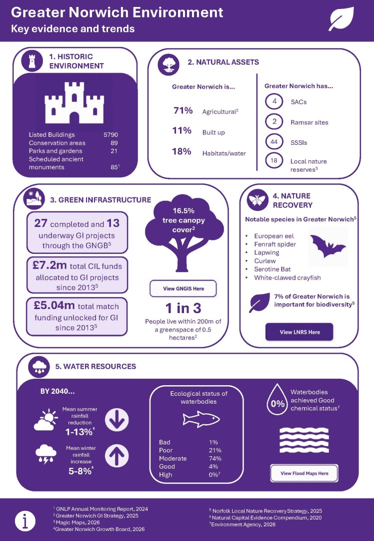
Greater Norwich Environment: key evidence and trends (full text)
1. HISTORIC ENVIRONMENT[1]
Listed Buildings: 5790
Conservation Areas: 89
Parks and Gardens: 21
Scheduled Ancient Monuments: 85
2. NATURAL ASSETS
Greater Norwich is[2]:
- 71% Agricultural
- 11% Built-up
- 18% Habitats/water
Greater Norwich has[3]:
- 4 Special Areas of Conservation (SACs)
- 2 Ramsar sites
- 44 Sites of Special Scientific Interest (SSSIs)
- 18 Local Nature Reserves (LNRs)
3. GREEN INFRASTRUCTURE
27 completed GI projects and 13 underway through the GNGB[4].
£7.2m total CIL funds allocated to GI projects since 2013[4].
£5.04m total match funding unlocked for GI since 2013[4].
16.5% tree canopy cover[2].
1 in 3 people lie within 200m of a greenspace of 0.5 hectares[2].
The factsheet also includes a button labelled:
"View GNGIS here".
This links to the following webpage: Green Infrastructure Strategy - Greater Norwich Growth Board
4. NATURE RECOVERY
Notable species in Greater Norwich[5]:
- European eel
- Fenraft spider
- Lapwing
- Curlew
- Serotine Bat
- White-clawed Crayfish
7% of Greater Norwich is important for biodiversity.
The factsheet also includes a button labelled:
"View LNRS here".
This links to the following webpage: Local Nature Recovery Strategy - What a Local Nature Recovery Strategy is - Norfolk County Council
5. WATER RESOURCES
By 2040:
- 1-13% mean summer rainfall reduction[6].
- 5-8% mean winter rainfall increase[6].
Ecological status of waterbodies:
- Bad: 1%
- Poor: 21%
- Moderate: 74%
- Good: 4%
- High: 0%
0% waterbodies achieved Good chemical status[7].
The factsheet also includes a button labelled:
"View Flood Maps here".
This links to the following webpage: Technical map - Check your long term flood risk - GOV.UK
References
[1] GNLP Annual Monitoring Report, 2024.
[2] Greater Norwich GI Strategy, 2025.
[3] Magic maps, 2026.
[4] Greater Norwich Growth Board, 2026.
[5] Norfolk Local Nature Recovery Strategy, 2025.
[6] Natural Capital Evidence Compendium, 2020.
[7] Environment Agency, 2026.
1The diversity in both the built and natural environment is a defining characteristic of Greater Norwich and is central to its distinctiveness and sense of place. This should be considered alongside additional housing and infrastructure needs to 2045.
Water efficiency
2The draft NPPF allows for local water efficiency standards to be employed where there is sufficient justification.
3According to the 2021 Environment Agency classification (Water stressed areas – 2021 classification - GOV.UK), Greater Norwich falls within an area of serious water stress. Although most of southern England falls within this category, this is particularly significant locally given the proximity to internationally protected water environments. The Broads and the Breydon & South Lopham Fens are RAMSAR sites and are also protected as Special Areas of Conservation (SACs). River Wensum and the Norfolk Valley Fens are also designated SACs, with the unique chalk streams of the Bure, Yare and Tud and others adding to the county's character.
Flood risk
4The existing GNLP already allocates the vast majority of development outside of areas at risk of flooding (see Map – Flood map for planning – GOV.UK and Norwich Urban Area SWMP - Norfolk County Council). However, there are locations where this is challenging to avoid, particularly brownfield river-side development sites in the City Centre.
5The draft NPPF separates flood risk into a distinct chapter alongside clearer guidance on the application of the sequential and exception tests and stronger emphasis on site selection and evidence requirements. This elevates flood risk as a primary spatial constraint and introduces a more rules‑based framework, likely superseding the more detailed criteria set out in existing development management policies.
Nature Recovery
6Greater Norwich has a wealth of natural environment assets. As well as two RAMSAR sites and four SACs, there are also 18 Local Nature Reserves (LNRs) and 44 Sites of Special Scientific Interest (SSSI) in the plan area. However, 96% of all waterbodies in the Greater Norwich area are classified as being in moderate or worse condition (https://environment.data.gov.uk/catchment-planning/ManagementCatchment/3008).
7Existing policy supports environmental enhancement, through high-level policies and includes requirements for development to address issues such as recreational impact on protected sites and nutrient pollution of waterways. DM policies similarly prioritise protection and mitigation of biodiversity impacts. The Environment Act also requires qualifying development to provide 10% net gain in the biodiversity value of a site.
8At present, nature recovery and biodiversity measures are typically delivered on-site or in close proximity to development. While this approach provides mitigation near the point of impact, it can result in fragmented and piecemeal provision. Strategic schemes are available to which developers may contribute in order to support wider-scale environmental enhancement; however, these are not always located close to the development site. The draft NPPF places greater emphasis on proactive, strategic nature recovery and requires local plans to take account of Local Nature Recovery Strategies when identifying growth locations. This includes both the selection of development sites and the identification of areas where nature recovery can be delivered most effectively.
Green and Blue Infrastructure
9In Greater Norwich, GI is already well embedded within existing policy. The Greater Norwich authorities produced the Green Infrastructure Strategy 2025 which identifies strategic and priority GI corridors providing a spatial framework for integrating nature recovery, accessible greenspace and water networks at all scales within Greater Norwich. These existing and proposed corridors provide a focus for strategic GI investment to enhance the connectivity of urban and rural communities, wildlife habitats and countryside destinations throughout Greater Norwich and beyond.
10While local policy is comparatively advanced, the draft NPPF encourages clearer linkages between GI delivery, climate outcomes and measurable standards. Specifically, the draft NPPF states that national GI standards should be used, unless local standards are justified.
Trees and Hedgerows
11Important trees can be protected through the serving of a Tree Preservation Order (TPO) – this process sits outside of the planning process. Tree canopy cover across the Greater Norwich area stands at 16.5%, at its highest in the Norwich City area (25.1%) and lowest in South Norfolk (14.1%). As a point of comparison, the Greater Cambridge area has a tree canopy cover of around 15%.
12Within existing policy, trees and hedgerows are generally protected through design and environmental criteria, with an emphasis on retention and mitigation.
13The draft NPPF introduces a more proactive approach, encouraging expansion and integration of green networks as opposed to reactive and protective measures. This means that local policies to require tree planting to serve new development and to protect existing trees may not be necessary.
Question 17 - Should the GNLP 2045:
- Set the most demanding local standards possible for water efficiency?
- Include higher or new standards for nature recovery and allocate sites for nature recovery or biodiversity enhancement?
- Identify sites for enhanced green infrastructure, including Suitable Alternative Natural Greenspace, and set local green infrastructure standards?
Design and Heritage
14With its wealth of historic assets, the historic environment is central to the character and quality of life of the Greater Norwich area and is a significant factor in its economic success through encouraging tourism and inward investment.
15Existing local policy contains criteria for design quality and heritage protection. The draft NPPF emphasises the use of design codes and masterplanning to promote sustainable, high-quality design and the NPPF also protects designated and non-designated heritage assets.
Landscape and Townscape Character
16Existing policy provides strong protection for landscape character and locally valued landscapes, primarily through criteria-based assessments. In the existing local plan this was considered the most suitable approach to landscape protection given that Greater Norwich does not have the exceptional circumstances required by Government to establish a Green Belt. There are particular protections for River Valleys, the Southern Bypass Landscape Protection Zone and two designated Strategic Gaps.
17South Norfolk also has a recently adopted Supplementary Planning Document (SPD) focusing on Landscape Susceptibility in relation to energy generation, storage and transmission. Given the context of significant large-scale energy projects being promoted in Greater Norwich through national decision making, consideration will need to be given to retaining this guidance in the GNLP 2045.
18The draft NPPF focuses on integrating landscape protection with wider objectives for biodiversity, climate adaptation and green infrastructure indicating that local policies may need to move beyond protection only toward enhancement and delivery of multifunctional benefits[MB2][AN3].
19Norwich has some taller buildings but also has an extensive network of listed buildings and Conservation Areas, which means development in some parts of the city (near Norwich Cathedral, for example) can be more sensitive than others. In order to consider building at higher densities within the city on brownfield sites, as strongly encouraged by national policy, careful consideration of differing maximum building heights in different areas may need to be considered through an appropriate study.
